Bolivia - Part 1 of 2: La Paz, Aymara Reed Boats on Lake Titicaca and Enigmatic Tiwanaku

Restaurant at Tiwanaku archaeological complex, Bolivia - Gateway to a civilization that vanished, now serving llama steak and mysteries
Our Bolivian adventure kicked off in the kind of place that makes you feel small in the best way possible. We're talking about the Andean Altiplano—a high-altitude plateau so vast and stark it feels like another planet. This is where ancient empires rose, where llamas outnumber cars, and where the air is so thin you get winded tying your shoes. Our first stop covered three iconic spots: the mind-bending city of La Paz, built in a bowl of mountains; a quiet Aymara village on the shore of legendary Lake Titicaca; and the head-scratching, awe-inspiring ruins of Tiwanaku. That last one, especially the Puma Punku area, is famous for stones cut so precisely that some TV shows wonder if aliens helped out. (Spoiler: the local archaeologists have other ideas, but it's fun to imagine!)
Bolivia itself is a country of superhero-level geography. It's landlocked, but has a navy (practice makes perfect!). It's home to the largest salt flat on Earth, mountains that scrape the sky, and a lake so high it's called "the birthplace of the sun." The culture is a vibrant mix of indigenous Aymara and Quechua traditions and Spanish colonial influence, all spiced up with modern politics and some of the friendliest people you'll meet.
Here is a map summarizing this part of our Bolivia trip.
December 26, 2022
06:13 AM

BoA (Boliviana de Aviación) flight departing Lima, Peru for Santa Cruz, Bolivia - Where Andean peaks become fluffy white pillows below
After our whirlwind three days in Peru, we had a plan: a scenic train, a comfy bus, a smooth border crossing. Bolivia had other ideas. Thanks to some political drama in Peru, our trains and buses were canceled. So, Plan B (or maybe Plan F) went into action: a quick flight to Lima, then a hop on Boliviana de Aviación. It wasn't the journey we planned, but flying over the Andes gave us views of snowy peaks and deep valleys that made us forget all about our original tickets.
Getting out of Lima's airport was its own little puzzle. We got our exit stamps, picked up our bags from the domestic terminal, and then had to step outside. One minute we're in air-conditioned bliss, the next we're hit with Lima's warm, humid hug. We shuffled along the sidewalk, dragging our suitcases, looking for the magic door back into the international terminal. It was like a weird, low-budget airport obstacle course.

Entrance to Lima airport international terminal - The unmarked door that separates domestic chaos from international limbo
Our flight to La Paz was waiting for us. The baggage allowance was crazy generous: "3 pieces per person, 23 kg each." That means our group of four could have checked twelve giant suitcases for free! We travel light, so we just checked our one suitcase and our carry-ons. But still, the thought was hilarious.
Airport security did take our Lysol spray and shaving cream, calling them "fire hazards." The process was very personal: they called our name, escorted us to a back room (by guys who looked like they meant business), and had us watch as they threw our stuff away. It felt more human than just finding a TSA note in your bag later.
Our real welcome to Bolivia happened at the Santa Cruz airport. Let's just say it was… thorough. First, they asked if we had COVID shots (but didn't check), and made us put masks on. Bolivia was still pretty strict about that. Then came the line dance. We got in the wrong line—a classic tourist move—because Americans need a special visa line to pay $160 each. Once in the right line, a very serious lady looked at all our papers: hotel bookings, tour invites, even our bank statements. She was not impressed. The problem? We didn't have a plane or bus ticket out of Bolivia.
We tried to explain we were driving out to Chile over a mountain pass. This led to an hour and a half of gentle panic, Google Translate, and hand gestures. Just as we were considering drawing a map, a super-friendly manager walked over. He spoke perfect English and saved the day. He told the visa lady, "It's okay, they're going to Uyuni and then to Chile," and just like that, we were back in business.
But wait! Paying the visa fee was next. We handed over $640 in cash. The officer treated each $100 bill like a rare artifact, folding it, holding it to the light, checking for who-knows-what. Three of our bills failed the test! We don't know why. We scrambled to find other bills, and after a few tries, we passed the secret U.S. money test. The visa itself is a whole page they glue right into your passport. It's serious business.
While this money drama was happening, we saw our suitcases doing lazy circles on the baggage carousel. Then the carousel stopped. A guy started loading them onto a cart! We waved our arms like we were landing a plane. He saw us, nodded, and parked the cart behind the counter. Phew. Crisis number two averted.
Finally, with our fancy new visa pages, we got our entry stamps and a "Welcome to Bolivia." Two hours after landing, we were officially in. It was a marathon, but it made the first Bolivian beer taste even better later.
Fun fact: Bolivia's time zone is one hour ahead of Peru's, even though it's not really further east. It's one of those quirky things that makes you go, "Huh."
La Paz, Bolivia (16.5° S, 68° W, altitude 13,250 feet)

La Paz and El Alto from airplane on final approach to El Alto - A city that looks like it was poured into a giant cereal bowl
Flying into La Paz is something you don't forget. The city is tucked into a huge hole in the ground, a canyon carved by the Choqueyapu River. Next to it, on the flat plain above, is El Alto—a massive, sprawling city that seems to go on forever. Together, they form one of the highest major metropolitan areas in the world. The air is thin, the views are insane, and your lungs will definitely let you know you're not at sea level anymore.
La Paz isn't just high; it's historically deep. The Spanish founded it in 1548 after kicking out the local Inca settlement. They named it "La Paz" (Peace), which is pretty funny considering how much silver and tin were mined from nearby mountains, causing centuries of conflict. The city was a major hub for wealth heading to Spain. Today, it's the political heart of Bolivia, famous for its markets, its cable car system, and women in beautiful bowler hats and wide skirts called polleras.
The mountains around La Paz aren't just pretty; they're sacred. The giant, snowy peak to the south is Nevado Illimani. It's over 21,000 feet tall and is considered a protective spirit, or Apu, by the local Aymara people. To the north is Huayna Potosí, a slightly smaller but famously climbable mountain. These giants watch over the city, reminding everyone of the power of nature.
We landed at El Alto International Airport. For a long time, this was the highest commercial airport in the world. Recently, China opened one in Tibet that's higher, but 13,325 feet is still nothing to sneeze at. Walking to baggage claim, you already feel the altitude. Take it slow, drink water, and maybe chew some coca leaves (it's legal and traditional here for altitude sickness!).

El Alto Airport baggage claim - Where your suitcase arrives slightly more out of breath than you are
The baggage claim area in El Alto feels pretty normal, until you remember you're standing at 13,325 feet! That's higher than the summit of many ski resorts in the Alps. The altitude here isn't just a number—it's a cultural fact. The local Aymara people have lived at these heights for thousands of years and have developed larger lung capacities and more red blood cells to cope. For us visitors, it's a constant, gentle reminder to slow down. The airport itself is named after the neighboring city of El Alto, which means "The Height" in Spanish. Pretty fitting!

Main lounge inside El Alto Airport - Where bowler hats and backpacks share the same space
The main lounge of El Alto Airport is a fascinating blend of the modern and the traditional. While it has cafes and shops like any airport, you'll also see many indigenous Bolivians in traditional dress. The women, known as cholitas, wear layered skirts, shawls, and those iconic bowler hats. There's a story that the hats became fashionable after a shipment of too-small bowler hats was sent from Europe in the 1920s and local women adopted the style. Now, it's a proud symbol of identity. Seeing these traditions alive in an airport lounge really sets the tone for Bolivia.
Next stop: a local SIM card. Everyone said to go with ENTEL for the best signal in the mountains. The store was right there in the airport. They only took cash, and they wanted to see our passports and boarding passes. For about six bucks, we got a week of data and unlimited WhatsApp. Worth every penny.

ENTEL mobile store, El Alto Airport - Your portal to connectivity in the land of ancient spirits
We fueled up on coffee and cake at an airport café (the altitude makes you crave carbs!), then headed outside to find a taxi. A local tip: only get into taxis with "AEROPUERTO" painted on them in blue and white. They're official and have fixed rates. We gave the driver the name of our hotel, Hotel Madrid, and off we went.
The road from El Alto down into La Paz is a spectacle. You start on the flat, dusty Altiplano and then the ground just drops away. The highway, called Autopista Héroes de la Guerra del Chaco, twists and turns down the side of the canyon. The views are jaw-dropping. You see the entire city of La Paz spread out below, a jumble of brick buildings covering every inch of the steep slopes.
Right before the toll booth, we got our first glimpse of the Mi Teleférico—the city's famous cable car system. It's not for tourists; it's how thousands of people get to work every day. Giant cabins glide silently over the rooftops, connecting the cities of La Paz and El Alto. It's like something from a sci-fi movie, but it's just public transit here.

Mi Teleférico cable cars over La Paz - Aerial gondolas that turned a two-hour commute into a 10-minute glide
The Mi Teleférico isn't just convenient; it's a social revolution on cables. Before it was built, commuting from the poorer hillside neighborhoods of El Alto down to jobs in La Paz could take hours in chaotic minibuses. Now, it's a quiet, 10-minute glide with a view. The system is a point of immense national pride, built with Austrian technology but paid for by Bolivia's nationalization of its natural gas industry. Each brightly colored line is named after a Bolivian icon or value, like the Orange Line ("Línea Naranja") dedicated to education. It's a symbol of progress literally floating over centuries-old cityscapes.
The toll plaza looked modern. Bolivia's highways are run by Vias Bolivia and administered by Administradora Boliviana de Carreteras (ABC). As we descended, the driver pointed out landmarks. The city grew up the sides of the canyon because the flat land was so limited. It's a lesson in creative urban planning, to say the least.

El Alto toll plaza for Autopista Héroes del Chaco - Where you pay to begin the plunge into the city bowl
The rest of the drive was a non-stop photo op. Every turn revealed a new angle of the city, with houses stacked like Lego bricks and the giant mountains in the background.

Expressway descending from El Alto to La Paz - The highway that turns geography into a rollercoaster
This view is what hits every first-time visitor. The highway, Autopista Héroes del Chaco, is named after the soldiers of the Chaco War (1932-1935), a brutal conflict with Paraguay over supposedly oil-rich land (which turned out to not have much oil at all). As you descend, you're looking at a city built in the crater of an extinct volcano. The steepness meant that for decades, the wealthier neighborhoods were at the more comfortable, lower altitudes, while the working-class settlements climbed the steeper, colder hills. The cable cars are helping to change that dynamic, but the geography is a constant reminder of social layers as real as the geological ones.

Valley views en route to La Paz - Where every bend offers a new postcard
Look at those terraced hillsides! Long before the Spanish arrived, the indigenous people of the Andes were master agricultural engineers. They built vast terracing systems (called andenes, which is where the word "Andes" comes from!) to create flat land for growing potatoes, quinoa, and corn on impossibly steep slopes. Some of those ancient terraces are still in use today. The modern city has basically built its neighborhoods on top of and around this ancient, sustainable landscape. It's a 500-year-old layer cake of history.

Autopista Héroes del Chaco, La Paz approach - Getting closer to the buzzing heart of the canyon
See those clusters of tall buildings? That's the city center, where the canyon floor is widest. This area, now home to government buildings and banks, was once the core of the Spanish colonial town. The Choqueyapu River, now mostly channeled underground, used to run right through it. The Spanish chose this spot because it was more defensible than the open Altiplano above. Local legend says the river's name comes from an Aymara phrase meaning "field of gold," hinting at the mineral wealth that would make this city so important (and so contested) for centuries.

Roadway descent with cityscape views - The concrete snake winding its way into urban chaos
These "stacked neighborhoods" are called barrios or laderas (slopes). Each one has its own character. The houses are often self-built, brick by brick, over generations. The bright colors you sometimes see are not just for fun; painting your house is a point of pride and a way to personalize a very vertical living space. In many of these neighborhoods, community is strong. There's a tradition called the Pasankalla where neighbors help each other move heavy materials up the steep streets—a modern version of the ancient ayni, a system of reciprocal labor that dates back to Inca and pre-Inca times.

Urban sprawl meets dramatic slopes - Proof that humans will build homes anywhere gravity allows
This final descent feels like you're being swallowed by the city. The walls of the canyon close in, and the urban noise grows. You're heading toward the Zona Central, the bustling heart. Just out of frame to the right is the infamous Camino de la Muerte, the "Death Road." Until 2006, it was the only northbound route out of the city—a narrow, unpaved cliffside track with a deadly reputation. Now, it's mainly a world-famous attraction for mountain bikers looking for an adrenaline rush with their scenery. We stuck to the nice, safe highway, thank you very much.
La Paz roadway - The final approach into the concrete jungle of the clouds
And here we are, right in the thick of it. The skyline is a jumble of architectural styles: leftover colonial balconies, 1960s concrete blocks, and shiny new glass towers. The prominent dome belongs to the Basilica of San Francisco, built in the 1700s. Its facade is a famous example of "Mestizo Baroque," where indigenous stone carvers sneakily incorporated local symbols like the sun and moon faces among the Christian figures. It's a perfect symbol of La Paz itself: a fusion of worlds, built on a breathtaking slope, and full of stories waiting to be discovered.
I picked Hotel Madrid because it was one block from the main square, Plaza Murillo. Sure enough, we drove past the imposing Legislative Assembly building and the plaza itself. One more turn, and we were there.

Plaza Murillo seen from Calle Bolivar - The political stage where pigeons now rule
This is the nerve center of Bolivian politics. The plaza is named for Pedro Domingo Murillo, a martyr of the 1809 independence movement. The story goes that before his execution by the Spanish, he declared, "The torch I have lit, no one will extinguish." That torch is now on the Bolivian coat of arms. The square has witnessed everything from presidential inaugurations to protests that toppled governments. The pigeons might look peaceful, but this ground has seen some serious drama.
Driving up one more block along C. Bolivar and taking a left on Indaburo gets us to our hotel.

Central La Paz streets near Hotel Madrid - Where colonial balconies watch over honking taxis
Calle Bolivar, like many streets in the center, is narrow and bustling. You can see the mix of old and new. The street is named for Simón Bolívar, "The Liberator," who helped free much of South America from Spanish rule. Ironically, the country named after him (Bolivia) was one he only visited briefly and later described as difficult to govern. Some local historians joke that he left and never looked back! The buildings here often have inner courtyards, a classic Spanish design that provides a quiet refuge from the chaotic street outside.

Indaburo street near Hotel Madrid, La Paz - The quiet alley where history takes a nap between revolutions
Indaburo is a quieter side street. The name likely has indigenous roots, though its exact meaning is debated. Many side streets in La Paz have names that are a puzzle of Quechua, Aymara, and Spanish influences. The yellowish building on the right is typical of older construction, using local materials. What's amazing is how these historic structures just barely hold back the pressure of the modern city growing up and around them. It feels timeless, but if you listen closely, you can probably hear the hum of a cable car passing somewhere overhead.
The official cab fare from El Alto airport to any downtown La Paz hotel is fixed by the administration at Bs.80. On reaching the hotel, I handed the cabbie Bs.100 in cash and waved for him to keep the change. He smiled and left and that was it — no discussion, no negotiation.
Hotel Madrid is located one block from Plaza Murillo. We had a great view of the plaza and surrounding buildings from our 5th floor room.

Plaza Murillo from Hotel Madrid, 5th floor - Your private box seat to Bolivia's political theater
That's the view! On the left is the Palacio de Gobierno (Government Palace), also known as the "Burnt Palace" after it was set on fire in 1875. In front of it is the statue of Murillo. The large building on the right with the columns is the Palacio Legislativo (Legislative Palace). The plaza's layout is classic Spanish colonial design: a central square flanked by the seats of religious power (the Cathedral, not visible here) and political power. For centuries, this design was meant to impress and control. Today, it's where people feed pigeons, protest, and celebrate. From up here, you get to see the whole stage.

Plaza Murillo square, daytime - Where history is written by pigeons and politicians
By day, the plaza is a hub of activity. You'll see shoeshine boys, women selling salteñas (juicy Bolivian empanadas), tourists, and government workers on a break. The central monument is topped by a statue of Murillo, but look closer at the base. It features bronze reliefs depicting scenes from Bolivian history and indigenous symbols. It's a 20th-century attempt to create a national myth that blends both the criollo (Creole) independence story and the country's deep indigenous heritage—a constant theme in Bolivia's struggle to define itself.

Plaza Murillo from hotel room - The view that comes with your morning coca tea
At ground level, you feel the scale. The Legislative Palace looks massive. The Greek-style columns are a common feature in many South American government buildings, symbolizing a connection to the democratic ideals of ancient Greece. Of course, the reality of Bolivian politics has often been more chaotic than Athenian! The guards you see are part of the Colorados de Bolivia, the Presidential Guard in their distinctive red uniforms. Their morning flag-raising ceremony is a precise, silent ritual that draws a small crowd every day.
Given its proximity, we found ourselves in Plaza Murillo multiple times during our stay.
Lake Titicaca and Sanca Jahuira (Huatajata): A cruise on an Aymara reed boat
2:00 PM

Reed boat on Lake Titicaca, Sanca Jahuira - Sailing on a mattress that doesn't sink, 15,000 feet above sea level
If you think your local lake is cool, wait until you hear about Lake Titicaca. Sitting at a lung-crushing 15,420 feet, it's not just the largest lake in South America; it's the highest navigable lake in the entire world. The water is a stunning, deep blue, and the sky feels close enough to touch. For the Aymara and Quechua people, this isn't just a lake; it's sacred. Inca legend says the sun god Inti was born here, and the first Inca king, Manco Cápac, emerged from its depths. So, yeah, it's a pretty big deal.
The Aymara people have lived here for thousands of years, and they build these incredible boats out of Totora reeds. The reeds are tied together with braided twine into these elegant, bobbing vessels. They're not just for tourists—the Aymara use them for fishing and for important ceremonies, like celebrating the summer solstice. The crazy thing? People have sailed similar reed boats across oceans, from Morocco to Barbados! It turns out this ancient technology is surprisingly seaworthy.

Traditional reed boat on Lake Titicaca at Sanca Jahuira - The original SUV: Sustainable Underwater Vehicle
This is a classic Totora reed boat, known as a balsa de totora. The reeds are harvested from the vast shallows of the lake, dried, and then tied in bundles. The boat's curved shape isn't just for looks; it helps it cut through the water. For the Aymara, the Totora reed is a "miracle plant." They use it to build boats, to make floating islands (like the famous Uros Islands on the Peruvian side), and even to eat the soft, white base of the stalks. The boats have a limited lifespan—they get waterlogged and rot after about six to twelve months—so building them is a continuous, living tradition, not a lost art.
In the afternoon, we drove about two hours from La Paz to the little village of Sanca Jahuira, near Huatajata. The landscape was pure Altiplano: wide-open, golden plains with herds of llamas and sheep, all under that massive blue sky.

Reed boat ready for cruising - The aquatic version of a woven basket, but way more floaty
Our boat awaits! The prow is often decorated, sometimes with a horse head or other figure. Notice how the reeds are bundled tightly? The skill lies in knowing exactly how tight to bind them. Too loose, and the boat falls apart; too tight, and it can't flex with the waves. The knowledge is passed down through families. The boat in the picture is relatively small, used for short trips and fishing. In ancient times, much larger versions were used for trade across the lake, carrying goods like potatoes, quinoa, and dried fish between communities.
There's a small museum and craft shop where Aymara women show how they weave incredibly soft and warm clothes from alpaca wool. Of course, I had to buy a poncho with a hood and a classic Bolivian hat with earflaps. When in Rome… or, you know, on the shore of a sacred lake at 15,000 feet.

Local museum and crafts store at Sanca Jahuira - Where stories are woven into fabric, not written in books
This humble museum is a treasure chest of local life. The weaving demonstrated here is an ancient art. The patterns (phallchas) woven into the textiles are more than decoration; they tell stories, identify communities, and convey status. Common symbols include the stepped diamond (representing the Southern Cross constellation or mountains), animals like condors and llamas, and geometric patterns that map the agricultural cycles. Buying a textile here directly supports these artisans and helps preserve a language of symbols that predates the written word in the Andes.

Authentic Alpaca carpets, ponchos and hats - Fashion that evolved over 6,000 years of shivering
And we're off! The water is incredibly clear and cold. Lake Titicaca is fed by glacier melt and rain, and it's so deep (over 900 feet in places) that it never freezes, despite the altitude. This made it a vital resource and transportation corridor for pre-Columbian civilizations. As we push off, think about this: people have been making this exact same motion in boats just like this for over 2,000 years. The technology is simple, but it's a direct link to the Tiwanaku culture, whose ruins we would visit later. They likely used larger versions of these very boats to move stone and goods across the lake.

Reed under preparation - Nature's own Styrofoam, harvested for boats and snacks
The craftsmanship is stunning. Alpaca wool is lighter, warmer, and softer than sheep's wool. The poncho, or poncho, is a practical garment for the unpredictable Altiplano weather. The hat with earflaps is called a chullo. In many communities, the patterns and colors of a chullo can tell you which village a person is from, and even their marital status. My new purchases weren't just souvenirs; they were my ticket to being a tiny bit warmer and looking like I vaguely knew what I was doing (I didn't).
The captain welcomed us aboard. The boat flew two flags: the red, yellow, and green Bolivian flag, and the colorful checkered Wiphala, the flag of the Andean indigenous people. As we pushed off, the silence was amazing. Just the sound of water and wind.

Wiphala flag on reed boat cruising on Titicaca - A 7-color checkered symbol of unity, waving over ancient waters
Gliding across this water is peaceful, but it's also a voyage through mythology. According to Inca legend, the creator god Viracocha emerged from the lake and created the sun, moon, stars, and the first people. The Aymara have their own creation stories tied to the lake. They believe that the world was once in darkness and the lake was the source of all life. Even today, many make offerings (ch'allas) to Pachamama (Mother Earth) and the lake spirits for good fishing and safe passage. Our simple cruise was, in a small way, floating on a sea of stories.
He pointed toward the horizon. "Out there," he said, "is Peru." The lake is so massive you can't see the other side. It felt like being on a gentle, golden sea.

On deck, calm waters and distant horizon on Titicaca - The world's highest infinity pool, with better views
That horizon holds secrets. Beneath these calm waters lie archaeological ruins. Near the Peruvian side, researchers have found submerged structures, including what appears to be a temple, dating back over 1,000 years. Local folklore speaks of a lost city called Wanaku that sank beneath the waves as punishment for human greed. Some theorize that rising water levels over centuries slowly swallowed Tiwanaku-era outposts. So when you look at that empty horizon, you're not just seeing water; you're looking at the roof of a drowned world, which makes a quiet boat ride feel pretty epic.

On ramp - The spongy, golden carpet that connects you to 2,000 years of lake life
The deck of a Totora boat is surprisingly springy and dry. The reeds are naturally buoyant and waterproof for a time. Standing here, you get a fisherman's-eye view of the world. For the local Aymara, fishing is not just a job; it's part of a reciprocal relationship with the lake deity, Mama Qota (Mother Lake). They believe she provides the fish, and in return, they must show respect through rituals and not overfish. It's a sustainable worldview that has kept these communities alive for millennia. Our gentle cruise was a brief glimpse into that balanced way of life.

Lakeshore view - Where the reeds meet the rocks, and civilization began
The shores are lined with Totora reeds, which form dense, floating beds. These reed beds are ecosystems in themselves, home to birds like the Titicaca flightless grebe and numerous fish species. They also act as natural water filters. For the people, they are a supermarket, hardware store, and pharmacy all in one. Beyond the reeds, you can see the harsh, dry hills of the Altiplano. This contrast—the fertile lake against the arid land—is why Titicaca was such a cradle of civilization. It was an oasis of resources in a high, cold desert.

Open water views on the Titicaca cruise - So much blue, it makes the sky look like a pale imitation
Out in the open water, the scale hits you. This lake is nearly 120 miles long. On a clear day, you can sometimes see the snow-capped peaks of the Cordillera Real on the far eastern shore. The lake itself is considered a living entity. There are stories of a serpent-like water spirit, sometimes called Khon, that inhabits the depths. It's not necessarily a monster; it's more like a powerful guardian that must be respected. Fishermen might make a small offering of coca leaves before heading out to stay on its good side. We didn't see any serpents, just breathtaking peace.

Skirting the reeds along the shore - Navigating the liquid fields where birds nest and legends are born
Navigating the reed beds requires skill. The captain knows the channels like the back of his hand. This intimate knowledge of the local environment is key to survival here. In the reeds, you might spot traditional fishing weirs or traps made from sticks and reeds. The method is ancient and low-impact. This is a far cry from industrial fishing; it's about harvesting what is needed from a place you know and respect deeply. It's a lesson in sustainability happening right in front of us.

Panoramic sweep across Titicaca - Where sky and water get into a mirroring contest and everyone wins
This panoramic view captures the essence of the Altiplano: vast, open, and dominated by sky and water. The light here is incredible—intense and clear because of the altitude. It's easy to understand why sun worship was central to the Tiwanaku and Inca cultures. The lake acts as a giant mirror for the sky, creating a sense of being between two heavens. For the ancient people, this wasn't just a pretty view; it was a cosmological map, with the water representing the underworld, the land the middle world, and the sky the upper world of the gods.

Returning toward the dock - The journey back to a world where houses don't float
Heading back, the village comes into view again. These lakeshore communities have a rhythm of life dictated by the lake and the sky. Afternoon often brings winds, so it's a good time to return. The simple houses are made of adobe bricks, which provide excellent insulation against the cold nights. Life here is not easy—the climate is harsh, and resources can be scarce—but there's a profound connection to place. The lake provides, the land sustains, and the community supports. It's a worldview we were just beginning to glimpse.

Dockside approach - The gentle nudge back to reality, one golden reed at a time
The floating restaurant is a clever adaptation. By building on the water, they don't need to own expensive shoreline property. It's likely anchored with ropes to poles driven into the lakebed, a technique used for centuries on Titicaca. The restaurant itself is probably built from eucalyptus wood and perhaps even has a floor of Totora reeds for insulation. Sitting inside, gently bobbing, drinking local coffee, you're experiencing a modern take on a very old lakeside lifestyle. It's simple, functional, and perfectly suited to its environment.
The best part? They had no snacks to sell us. So, they had gone to the next town just to buy those cookies for our group. And they refused to take any money for them! I insisted on paying for the cookies at least. It was one of those beautiful, humble moments of kindness that you remember more than any famous landmark. People with not much, giving everything.

Cookies and coffee at the floating restaurant - Hospitality served on a wobbling plate, no charge for the view
This simple act of hospitality is rooted in the Andean principle of Ayni. It's not charity; it's a profound concept of reciprocal exchange and community responsibility. You help others when you can, trusting that the community will support you when you need it. By offering us cookies and coffee, they were incorporating us, however briefly, into their social web. Our attempt to pay was a foreign concept. The real "payment" was our gratitude and the shared moment. It was a cultural lesson served on a plate with cookies.
The Chinese automobiles of Bolivia
7:00 PM
Driving around La Paz and El Alto, I felt like I was in a car-spotting game show. "Name that brand!" I failed miserably. The roads are flooded with Chinese car brands you've probably never heard of. They're affordable, they come with easy financing, and they're everywhere. Meanwhile, a fancy Toyota or BMW really stands out. Private cars aren't super common—most people use minibuses or trufis (shared taxis)—so the car market is fascinating.
Some of the weird and wonderful models we saw:
- Foton View C2 Supporter (A minivan that sounds like a supportive friend)
- Jupiter MSOS (Sounds like a spaceship, looks like a van)
- King Long Kingwin (A name that's trying very, very hard)
- JAC JS3 (A sleek-ish SUV)
- FAW ACTIS V80L (No idea, but it looked serious)
There's also a whole other world of "chutos"—contraband cars smuggled into the country. Let's just say the automotive scene in Bolivia is anything but boring.

Foton View C2 Supporter - The workhorse of the Andes, carrying families, chickens, and dreams uphill
The Foton is a common sight. This Chinese brand has aggressively targeted developing markets like Bolivia. These vans are the workhorses of small businesses—used as shared taxis, delivery vehicles, and minibuses. They're cheap to buy and run, which is crucial in a country with a large informal economy. Seeing a "Foton View C2 Supporter" ferrying families up the steep hills of El Alto is a perfect snapshot of Bolivian pragmatism: it's not about brand prestige; it's about what gets the job done on a tight budget.

Jupiter MSOS - Not a gas giant, but definitely a people-mover giant
Jupiter? It's not a planet; it's a van! This is another example of Chinese manufacturers creating vehicles specifically for rough roads and high altitudes. Many of these brands have virtually no presence in North America or Europe but are household names in parts of Africa, Asia, and South America. The "MSOS" badge might sound high-tech, but under the hood, it's simple, reliable mechanics that any local mechanic can fix. In a country where official dealerships are rare outside big cities, that's a major selling point.

King Long Kingwin - When you want your bus to sound like it won a medieval tournament
King Long specializes in buses and coaches. The "Kingwin" model is a smaller bus, often used for inter-city travel or as a private shuttle. The name is a hilarious and bold attempt to sound regal and successful in English. It reflects a global trade reality: China is now a major exporter of vehicles to Latin America, often through favorable government-to-government loans and trade deals. So, a "King Long" on a Bolivian street is a rolling symbol of 21st-century South-South trade and shifting global economics.

King Long Super GLS - The land yacht for crossing salt flats and mountain passes in (relative) comfort
Another King Long, this time a larger bus. Bolivia's geography makes long-distance travel by road challenging and time-consuming. Buses like these are the lifelines connecting remote communities to cities. They rumble over high mountain passes and across the salt flats. The "Super GLS" tag promises a bit of luxury (reclining seats, maybe a bathroom) for journeys that can last 12 hours or more. Inside, you'll find a microcosm of Bolivia: families, traders, students, all sharing the long road together.

JAC JS3 - The Chinese SUV that dreams of being a Toyota, perfect for La Paz potholes
JAC (Jianghuai Automobile Co.) is one of the bigger Chinese automakers. The JS3 is a compact SUV, a popular body style worldwide for its perceived ruggedness. In Bolivia, where road conditions can be terrible, an SUV makes practical sense. This model represents the aspirational vehicle for Bolivia's growing middle class—more stylish than a work van, but still affordable. Its presence shows how Chinese brands are moving beyond basic transportation and into the consumer desire for status and comfort.

FAW ACTIS V80L - A name that sounds like a password, for a van that looks like it knows all the shortcuts
FAW (First Automobile Works) is one of China's oldest and largest state-owned car manufacturers. The "ACTIS V80L" looks like a serious people-mover. Vehicles like this are often used as fixed-route taxis or for hotel shuttles. The dominance of these brands is a direct result of trade policies. Import tariffs on vehicles from traditional manufacturing countries (like Japan, the US, or Europe) are extremely high, often over 40%, to protect local assembly plants and encourage trade with alternative partners like China and India. So, your average Bolivian car buyer is looking at a very different showroom floor than we are.

KEYTON V60 - Proof that in Bolivia, your car's name can be a delightful mystery
And here's a KEYTON. The naming strategy is fascinating: often a mashup of English words meant to evoke strength, technology, or success ("Key" + "Ton"). It's a visual reminder of Bolivia's economic reality. With limited domestic industry, it's a net importer of finished goods. The cars on the street tell a story of global trade routes, economic alliances, and the purchasing power of everyday Bolivians. It's a constantly rolling anthropology lesson, and it makes traffic jams slightly more interesting.
December 27, 2022
06:30 AM
Plaza Murillo, La Paz
I woke up early, drank some coca tea in the hotel lobby (the miracle cure for altitude headaches), and walked five minutes to Plaza Murillo. This is the main square, named after Pedro Domingo Murillo, a martyr of the 1809 independence movement who was captured and executed by the Spanish in 1810. His statue stands in the middle, usually covered in pigeons.
The square is surrounded by heavy-hitter buildings: the Presidential Palace (nicknamed the "Burnt Palace" after a fire), the huge Metropolitan Cathedral, and the Plurinational Legislative Assembly. It's where protests happen, presidents give speeches, and tourists wander around looking up. During our visit, it was all dressed up for Christmas with a giant tree and lights—a weird mix of solemn history and holiday cheer.

Palacio de Gobierno and the Metropolitan Cathedral of La Paz - Church and State in an eternal staring contest
The Palacio de Gobierno (on the left) has a dark nickname: Palacio Quemado, the "Burnt Palace." It earned this after being set ablaze by a mob in 1875, during one of Bolivia's many political uprisings. The current building is a reconstruction. The president works here, but interestingly, doesn't live here. The balcony is where leaders address the crowds. The Cathedral (center) took over 150 years to build, from 1835 to 1989! Its neoclassical facade hides an interior that's surprisingly modern. The juxtaposition of these two powers—church and state—facing each other across the square is classic Spanish colonial urban planning.

Pedro Domingo Murillo monument with the Legislative Assembly behind - A hero on a pedestal, watching over the messy democracy he helped start
The monument to Murillo is the plaza's centerpiece. The bronze statue shows him in a heroic pose. The base is more telling: it features allegorical figures representing the ideals of the independence movement—Liberty, Justice, etc. Murillo's legacy is complex. He was a mestizo (mixed Spanish and indigenous ancestry) who led a criollo (American-born Spanish) revolt. The revolution he helped start was ultimately for the independence of the colonial elite, not the indigenous majority. It would take another 200 years for that majority to claim political power, culminating in the presidency of Evo Morales. So this statue represents both a founding myth and the long, unfinished struggle for a truly inclusive Bolivia.

Plaza Murillo dressed for Christmas - Where political tensions get a temporary truce for tinsel and lights
The Christmas tree is a relatively recent tradition here. Bolivia's population is predominantly Catholic, a legacy of Spanish colonization, so Christmas is widely celebrated. However, December also coincides with the Andean summer solstice and the celebration of Willkakuti (the Aymara New Year) on December 21st. So, while the tree and lights represent a imported Christian tradition, the timing overlaps with ancient indigenous celebrations of the sun's return. The plaza, for a few weeks, becomes a blend of these two calendar systems—one marking the birth of Christ, the other the rebirth of the sun.

Festive lights at Plaza Murillo - Electricity doing its best to compete with starlight at 13,000 feet
The lights add a magical layer to the historic architecture. The Legislative Assembly building, illuminated in blue, houses Bolivia's congress. Since the refounding of Bolivia as a "Plurinational State" in 2009, this building is meant to represent not just a single nation, but a coalition of 36 indigenous nations alongside the mestizo population. The lights, in a way, democratically beautify all the buildings—the old colonial Cathedral, the presidential palace of a republic, and the assembly of a plurinational state—wrapping them all in a shared, festive glow, if only for the season.

Holiday décor around the square - Proving that even revolutionary squares love a good sparkle
The decorations extend beyond the tree. You can see strings of lights and what look like giant presents or stars. This public celebration is important in a city of stark economic contrasts. For many families, coming to see the lights in the main square is a free and special holiday outing. It creates a shared experience, a moment of wonder that momentarily bridges the vast social divides in Bolivian society. The square, so often a stage for conflict, briefly becomes one for shared joy and light in the long Altiplano night.
The backwards moving anti-clockwise clock
Okay, this is the coolest thing. On the Legislative Assembly building, there's a clock that runs backwards. Counter-clockwise. The numbers go from 1 to 12 to the left. It's called "The Clock of the South." They inaugurated it in 2014 as a symbol of independence from northern hemisphere traditions. The idea is that in the southern hemisphere, sundial shadows move "backwards." It's a brilliant piece of political theater on a clock face. It chimes with the Big Ben tune, which is hilariously British for such a rebellious clock.

Anti-clockwise Legislative Assembly clock - Time itself, giving the middle finger to Greenwich Mean Time
This clock is more than a quirky tourist photo op; it's a profound political statement. Installed during the presidency of Evo Morales, Bolivia's first indigenous president, it symbolizes a decolonization of time and space. The argument is that the Global North has imposed its systems—including clockwise time—on the world. By reversing it, Bolivia asserts its southern hemispheric identity and intellectual sovereignty. The fact that it still chimes with the tune of London's Big Ben is the ultimate ironic twist: it uses a symbol of the old colonial power to mark its own, rebellious version of time. It perfectly captures modern Bolivia's defiant, complex, and creative spirit.
Flag hoisting ceremony
I got to the square just before 7 AM for the daily flag-raising ceremony. The Presidential Guard, called the Colorados de Bolivia for their red uniforms, marched out with perfect discipline. Precisely at seven, the backwards clock chimed the Big Ben tune (of course), and they raised the Bolivian flag and the Wiphala together. It was a powerful, silent moment of patriotism. You can watch a short clip of it below.
We came back that evening to see the plaza lit up in the rain. The Christmas lights reflected on the wet pavement, and it was magical.
December 27, 2022
09:00 AM
Tiahuanaco (Tiwanaku) and Puma Punku
"Any sufficiently advanced technology is indistinguishable from magic." — Arthur C. Clarke
.JPG)
Tiwanaku complex - The Lego set of the gods, scattered by time and earthquakes
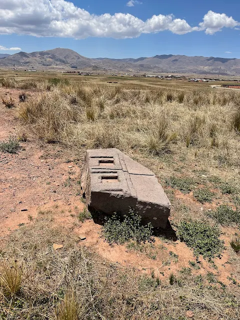
I've seen the Pantheon, the Taj Mahal, Machu Picchu. But nothing, and I mean nothing, prepared me for the goosebumps I got at Tiwanaku. This place is old. We're talking 1500 years old, at least. It was the capital of a powerful empire that ruled the Andes long before the Inca showed up. And the stonework… oh, the stonework. It's not just big; it's impossibly precise. We're talking blocks of hard andesite stone cut with laser-like straight edges, perfect right angles, and holes drilled with such consistency it makes modern engineers scratch their heads.
The most famous part is Puma Punku ("Gate of the Puma"). This is where you find the famous "H-blocks," stones with complex geometric cuts that look like giant Lego pieces. They weigh tons, and they fit together without mortar. How did they do it? Some say with simple stone tools and incredible skill. Others… well, others point to the TV show Ancient Aliens. The current boring-but-probably-true theory? They might have used a kind of ancient concrete, pouring a geopolymer mixture into molds. Still, seeing it in person makes you wonder.
Bienvenidos a Tiwanaku
We drove about an hour and a half from La Paz onto the flat, windswept Altiplano. The site felt quiet, almost abandoned, maybe because of the pandemic's long shadow. The entrance had a sad, closed restaurant and an open ticket booth.
Next to the entrance is an old, abandoned train station for "Tiahuanaco." The sign says the altitude is 3,870 meters (12,697 feet). That makes Tiwanaku even higher than La Paz and way higher than Machu Picchu. This was the highest capital city in the ancient world.

Approach road to Tiwanaku archaeological site - The modern path to a pre-modern mystery
This road has been a pathway for over a thousand years. In Tiwanaku's heyday (c. 500-1000 AD), this wasn't a quiet backroad; it was likely a busy thoroughfare for pilgrims, traders, and laborers coming to the spiritual and political heart of a vast influence sphere. The modern pavement covers layers of history. The site's current quietness is deceptive. At its peak, the city and its immediate surroundings may have been home to tens of thousands of people, with a complex society of priests, artisans, farmers, and astronomers.

Old Tiahuanaco rail station beside the site entrance - Where 19th-century ambition met 6th-century ruins
The abandoned train station is a ghost from a more recent era of ambition. It was part of a late 19th/early 20th-century railway project intended to connect Bolivia with Peru and the Pacific Ocean. The railway brought archaeologists, looters, and modernity to Tiwanaku's doorstep. Before the train, the site was known mainly to local Aymara communities, who considered it a sacred place (wak'a) built by their ancestors or even by gods in a previous age of the world. The train symbolizes the moment when Tiwanaku transitioned from local legend to a subject of global archaeological fascination.

Platform and signage at the old Tiahuanaco station - A signpost for a civilization that vanished before signposts were invented
The sign reading "TIAHUANACO 3870 m.s.n.m" is a marker of both altitude and identity. The Spanish colonists called the site "Tiahuanaco." The modern Aymara name is "Tiwanaku." The difference is subtle but significant—one is a Hispanicized version, the other a reclamation. The altitude, 3870 meters above sea level, is a key to understanding the civilization's achievements. Thriving and building monumental architecture at this height required incredible biological and social adaptation. They developed freeze-resistant potato varieties and raised camelids (llamas and alpacas), creating a food surplus that allowed for a non-farming priestly and artisan class.
Tiwanaku archaeological site overview
The site is huge. Only a fraction has been dug up. It was a major religious and political center, and its influence stretched for hundreds of miles. They had advanced agriculture, a complex society, and they moved stones weighing over 100 tons from quarries miles away. How? Good question. They probably used log rollers, ropes, and a lot of people.

Visitor map of the Tiwanaku complex and tour route - Your treasure map to a city of ghosts and stone
This map is a guide to a city of the mind as much as of stone. Tiwanaku was likely laid out as a giant cosmogram—a physical model of the universe according to Tiwanaku belief. The east-west alignment of major structures like Akapana and Puma Punku tracked the sun's path. The different temple complexes may have represented different cosmological realms or deities. Walking the route isn't just a tour of ruins; it's a walk through a ancient philosophical and religious system, where architecture, astronomy, and power were completely intertwined.

Chronological chart of Tiwanaku/Pumapunku - A civilization's resume, with 'climate change' in the 'reason for leaving' section
The timeline shows a civilization that rose, flourished for centuries, and then, around 1000-1100 AD, entered a rapid decline. Why? The leading theory is a massive drought lasting decades, possibly linked to a shift in Pacific Ocean patterns. The agriculture that sustained the city failed. The social and religious order collapsed. People left. The stones were left silent. This chart is a humbling reminder of the power of climate. The most sophisticated society in the southern Andes was brought low not by invaders, but by a long-term change in the weather—a lesson that feels very relevant today.
Walking in, you're immediately surrounded by the bones of a city. The path is lined with perfectly cut stones, some just lying there, abandoned centuries ago.

Pathway across the Tiwanaku complex - Walking on the scattered puzzle pieces of a forgotten empire
This pathway is a modern convenience for visitors. In ancient times, the ground would have been covered in a hard plaster, perhaps painted. The scattered stones you see are the result of centuries of looting and natural decay. After the city's collapse, it became a quarry for later cultures, including the Inca and even the Spanish, who used Tiwanaku stones to build churches and bridges. Every missing stone is a page torn from a history book. What remains is just a fragment, yet it's still overwhelmingly impressive.

Stonework and vistas on the way to Akapana - Where human ambition meets geological reality, and they shake hands
The vista shows the relationship between the built environment and the natural one. The flat Altiplano stretches to distant mountains. Tiwanaku didn't just exist in this landscape; it was designed to engage with it. Certain sightlines from the temples likely aligned with mountain peaks (Apus) on the horizon, which were considered sacred. The civilization was an active participant in a sacred geography, building their city as an axis mundi—a center of the world that connected the earth to the heavens.

Cut stones and platforms across the site - The foundation of a society that believed in straight lines and right angles
These stone blocks and platforms are the foundation of everything. They are made of red sandstone, which is relatively soft and easier to cut than the andesite used for finer carvings. The size and weight of these blocks indicate a highly organized society capable of mobilizing large labor forces. This wasn't slave labor, as in some ancient societies; it was likely based on a system of reciprocal labor obligations (mit'a) that would later be adopted and expanded by the Inca. People contributed their work as part of their communal and religious duty, probably during agricultural downtime.
Pyramid of Akapana
The first major structure is the Akapana Pyramid. Today it looks like a big grassy hill, but 1400 years ago it was a massive, stepped pyramid faced with stone. It was aligned perfectly with the cardinal directions. We climbed to the top, huffing and puffing in the thin air. From up there, you can see the whole site and feel the scale of the place. The stones that are left have these incredibly sharp edges. You can run your hand along a cut made over a millennium ago and it's still smooth.

Schematic of Akapana's upper platform and surviving stones - The architect's blueprint, weathered by 1,500 years of wind
Akapana was not just a pyramid; it was a man-made sacred mountain. In Andean cosmology, mountains (Apus) are living deities, sources of water and protectors. By building Akapana, the Tiwanaku people were creating their own Apu at the center of their world. It likely had a sunken court at the top for rituals. Some theories suggest it also functioned as a massive water collection and distribution system, channeling rainwater through internal stone ducts—a fusion of spiritual symbolism and brilliant hydrological engineering. It was the ultimate statement of power over both nature and society.

Massive blocks and cut faces on Akapana - Stones so big they make you wonder about the size of the ancient forklift
The size of these sandstone blocks is daunting. They were quarried from several miles away and transported without the wheel or draft animals. How? The consensus is on log rollers, leather ropes, and sheer human power. But the organization required is mind-boggling: planning the route, feeding the workers, maintaining morale. It speaks of a society with a powerful unifying ideology—a shared belief system so strong that people would devote years of their lives to moving earth and stone for a communal vision they might not live to see completed. That's faith, manifested in geology.
The rest of the photos from Akapana show the insane precision and the sheer number of stones. Some have slipped down the sides, others are still locked in place. Every corner is a perfect 90 degrees.
Slip-down stones along Akapana's flanks - Gravity's slow victory over human engineering
These slipped stones tell a story of both construction and decay. They may have been dislodged by earthquakes, which are common in the Andes, or by the relentless freeze-thaw cycles at this altitude. Water seeps into cracks, freezes and expands, slowly prying even the most perfectly fitted stones apart over centuries. Their current scattered state is a lesson in entropy. No matter how grand the human design, nature ultimately has the final say. The Tiwanaku builders knew this—their entire worldview was based on balancing human activity with natural forces—but even they couldn't stop time.

Terrace blocks and cut angles on Akapana - The world's oldest and most earthquake-resistant staircase
The terracing served multiple purposes: structural stability for the pyramid, defining sacred spaces, and creating processional pathways. The sharp angles are a Tiwanaku signature. Achieving such precision on large sandstone blocks likely involved a combination of techniques: hammering with harder stone tools, abrasion with sand and water, and possibly the use of guided straight-edges. The corners aren't just aesthetically pleasing; they create interlocking joints that resist seismic shaking, a necessary feature in earthquake country. It's beauty born of brutal necessity.

Precisely finished faces and corners - Proof that 'close enough' wasn't in the Tiwanaku dictionary

Standing stones edging Akapana's top - The ancient guardrails for a pyramid-top party
These standing stones, or orthostats, lining the upper platform would have been impressive. They might have supported a wall or roof, or simply stood as sentinels. They create a rhythm and frame the sacred space at the summit. If you imagine them covered in plaster and painted with bright colors (as they likely were), the effect would have been dazzling, especially under the intense Altiplano sun. The pyramid wasn't a somber, gray monument; it was a vibrant, polychrome beacon visible for miles, announcing the power and piety of the city at its feet.

Upper platform stones with crisp geometry - The VIP section for priests and astronomers

Cut stones with sharp edges on the mound - Nature's rocks, told to sit up straight and behave

Corner alignments and stepped faces atop Akapana - Where geometry meets spirituality at a 90-degree angle

Akapana's stepped terraces from the descent - The view on the way down, when your lungs finally forgive you
Looking down from the top, the stepped design becomes clear. Each terrace was a distinct level, possibly with specific ritual functions or restricted to certain classes of priests. The staircase, now gone, would have been a focal point for processions. Ascending Akapana was likely a ritual act of moving closer to the sun and the gods, a physical and spiritual climb. The sheer labor of building it was itself a form of mass ritual, an offering of sweat and time from the population to the divine powers that governed their world.

Broad terrace faces and cut blocks on Akapana - The ancient version of a multi-level car park, but for gods

Precision joints and fallen stones on the flanks - A 1,500-year-old game of Jenga, paused mid-collapse

Corner alignments and terrace edges - The Tiwanaku equivalent of 'measure twice, cut once'

Large cut faces and joints in situ - Stones that have been napping in the sun since the Dark Ages

Stepped alignment along Akapana's side - The original stadium seating, for watching celestial events

Upper platform stones and views across the site - The CEO's office of the Tiwanaku empire
The view from the top is the reward. You can see the entire ceremonial core: the Semi-Subterranean Temple, the Kalasasaya platform, and the distant mound of Puma Punku. This vantage point was reserved for the elite—the priests and rulers who mediated between the people and the gods. From here, they could observe ceremonies below, track celestial events on the horizon, and literally look down upon their domain. It was the ultimate seat of power, both spiritual and temporal, in the Tiwanaku world.

Schematic of Cut blocks and descending terraces - The architectural equivalent of a topographic map

Andesite faces with crisp geometry - The hard stuff, cut like butter by people who apparently never heard of metal tools
Here you see the transition from the rough, large sandstone blocks of the foundation to the finer, hard andesite detailing. Andesite is a volcanic rock, much tougher than sandstone. Working it to this smoothness with stone or copper tools would have been a slow, labor-intensive process. The different materials might have had symbolic meaning: sandstone from the earth, andesite from the fiery volcanoes, together representing different realms of existence. Every material choice in Tiwanaku architecture was likely loaded with meaning.

Block edges, faces, and tooling traces - The fingerprints of masons who died 40 generations ago
The aligned courses of stone show incredible planning. Building a pyramid isn't just piling rocks; it requires careful calculation of weights, slopes, and drainage. The builders had to account for settlement over time. The fact that these walls are still standing (even if partly collapsed) after 1200 years of earthquakes, floods, and neglect is a testament to their engineering skill. They understood their materials and their environment intimately. This wasn't guesswork; it was applied science, developed through generations of trial, error, and passed-down knowledge.

View along the slope with aligned courses - A testament to what humans can build when they're not distracted by the internet
Up close, you can sometimes see the marks left by the tools—grooves from pounding or scraping. These are the fingerprints of the artisans. We don't know their names, but their work endures. They weren't just laborers; they were highly skilled craftsmen. The consistency of the work across thousands of blocks suggests a standardized training system or a guild-like structure. These marks connect us directly to the individuals who, stroke by stroke, shaped the vision of their civilization into solid rock. It's a humbling and intimate connection across a vast gulf of time.
Kantatallita — Light of Dawn
Next was Kantatallita, a smaller temple area. The star here is a single, massive block of andesite carved to look like a miniature temple model, complete with tiny staircases and a sunken courtyard. It's like a giant's dollhouse. Why did they make it? Maybe as a blueprint, maybe as a ceremonial object. Nobody knows, but its precision is mind-blowing.

Kantatallita's open rectangular temple with carved monoliths - The ancient courtyard where the sun was invited for breakfast
Kantatallita means "Place where the light enters" or "Light of Dawn" in Aymara. This name, given in modern times, hints at its possible function. The open rectangular courtyard is surrounded by stones. It might have been an initiation chamber or a place for rituals related to the sun's first light. The carefully placed monoliths within could have been used for astronomical observations, marking the sunrise on specific days like the solstices. It's a more intimate, enclosed space compared to the grand plazas, suggesting secret or elite ceremonies.

Miniature temple block: stairs, courtyard, and square sockets - The world's heaviest and most detailed architectural model
This is one of Tiwanaku's great mysteries. The "temple model" block. It's carved from a single piece of andesite. The tiny staircases (each step only a few inches high) and the perfect courtyard are uncanny. Theories abound: Was it an architect's scale model? A teaching tool for initiates? A representation of the mythical origin place of the Tiwanaku people? The square sockets on the top platform likely held small stone monoliths or metal ornaments. It feels like a ritual object, a concrete representation of sacred architecture that could be used in ceremonies, perhaps with liquid offerings poured into the sunken court.

West platform: three stairs and twin rows of square holes - The details that fuel a thousand 'ancient astronaut' theories
The precision here is staggering. The twin rows of square holes are perfectly aligned and sized. They could have held a small, removable facade or banners. The three stairs leading up to it are symbolic. The number three is significant in Andean cosmology, often representing the three worlds: the Hanan Pacha (upper world of gods and stars), Kay Pacha (this world), and Uku Pacha (the inner world or underworld). Ascending these miniature stairs in a ritual could have symbolized a spiritual journey between these realms. It's a whole cosmology in miniature.

East side: twin stairs down toward the courtyard - For the ceremonial descent of the sun's rays (or very small priests)
The east side, facing the rising sun, has twin stairs descending into the courtyard. This could represent the descent of the sun's light into the earthly realm, or the path of initiates into a sacred space. The symmetry is perfect. The ability to carve such delicate, complex features into extremely hard andesite, without shattering the block, indicates tools and techniques that are still not fully understood. Some researchers speculate about the use of tubular drills with abrasive sand, or even lost knowledge of stone-softening plant compounds. Whatever the method, the result is a masterpiece of lapidary art.
There was also a beautiful stone arch on the ground, carved with figures. You could see little holes where sheets of gold were once nailed to it. The Spanish probably took the gold, leaving behind the ghost of its former glory.

Gate-top frieze with sculpted figures (former gold plating) - The VIP entrance, now missing its bling
This fallen arch is a heartbreaking glimpse of lost splendor. The carved figures are likely a procession of deities or priests. The small holes held golden nails or staples that secured thin sheets of gold leaf over the entire surface. Imagine this arch standing at a doorway, catching the first rays of the dawn sun, blazing with reflected gold. For the Tiwanaku, gold (quri) was not money; it was "the sweat of the sun," a sacred material that embodied the sun god's essence. Covering stone with gold was a way to infuse architecture with divine power. The Spanish looters saw currency; the Tiwanaku saw frozen sunlight.
Other stones lay around with intricate channels and holes cut into them. The purpose of many of these is a mystery. Were they for water? For blood from sacrifices? For anchoring something? Your guess is as good as an archaeologist's.

Intricate carvings amid scattered stones - The jigsaw puzzle from hell, missing most of its pieces
These scattered blocks are a jigsaw puzzle from a lost culture. The channels could be part of a sophisticated hydraulic system for ritual ablutions or for channeling rainwater or sacrificial liquids (like chicha maize beer) during ceremonies. The holes might have been for wooden beams that supported a roof or a canopy. Each block was part of a larger whole, a single note in a architectural symphony. Now, they lie like discarded words from a forgotten language. Archaeologists painstakingly measure and catalog each one, trying to reconstruct the sentences, the paragraphs, the epic poem that was Tiwanaku.

Faces, niches, and channels carved in stone - The ancient equivalent of electrical outlets and USB ports, but for spirits
The sculpted faces and niches are particularly evocative. The faces may represent ancestral spirits or minor deities. Setting a stone face into a wall was a way of giving that spirit a home, a place to watch over and protect the space. The niches could have held small idols, offerings of precious objects, or the mummified remains of important ancestors. In Andean tradition, ancestors (mallquis) were not gone; they were active participants in the community's well-being. These carved stones provided them a doorway between worlds, ensuring their continued presence and blessing.

Precision recesses and geometric profiles - Stonework so exact it makes IKEA furniture look sloppy
The geometric precision seen here goes beyond mere decoration. It reflects a worldview that valued order, balance, and symmetry as reflections of cosmic harmony. The perfect lines and angles were an attempt to mirror the perceived order of the heavens. By creating such order on earth, the Tiwanaku were perhaps trying to influence the cosmos, to ensure the regular cycles of the sun, rain, and seasons upon which their survival depended. The stonework was, in a very real sense, a form of prayer—a permanent, physical prayer for balance and continuity.
On the path, we passed two monoliths that were like displays of stone-cutting skill. They had grids of perfect square holes, sharp edges, and smooth faces. They looked more like industrial parts than ancient art.

Geometric recesses and sharp edges on a monolith - The Swiss cheese of the ancient world, but made of rock
This monolith is a technical marvel. The grid of square recesses is millimetrically precise. Their purpose is unknown—perhaps they held inlays of different colored stone or metal, creating a dazzling mosaic effect. The sharp, clean edges suggest the use of precise guiding tools, perhaps wooden or stone jigs, to ensure consistency. It looks like a piece of modern machine-tooled equipment. That's what is so disorienting about Tiwanaku: the aesthetic feels simultaneously ancient and unnervingly modern or even futuristic. It challenges our linear notion of technological progress.

Perfectly planar faces and right angles - The kind of straight edge that would make a carpenter weep with joy
Creating perfectly planar (flat) faces on hard andesite is incredibly difficult. It likely involved a process of "grinding and matching." Two stones would be rubbed together with an abrasive sand slurry until their faces were perfectly flat and could fit together without gaps. The right angles were probably achieved using set squares, perhaps made of wood or stone. The knowledge wasn't just in the cutting, but in the meticulous measuring and checking. This level of quality control over hundreds and thousands of blocks implies a rigorous system of master craftsmen overseeing the work of apprentices, passing down standards that had to be met.

Grid of recesses with millimetric precision - Ancient Sudoku, carved in stone for eternity
The grid pattern is hypnotic. Such repetitive, precise work has a ritualistic quality to it. It may have been meditative for the artisan, a physical act of devotion. In many cultures, repetitive geometric patterns are used to induce trance states or to represent the underlying order of the universe. This grid could be a physical manifestation of the Tiwanaku concept of Pacha—time and space woven together. Each square might represent a unit of space, a moment in time, or a field in the agricultural cycle that sustained them. It's art, math, and metaphysics carved in stone.

Crisp corners and channel terminations - The stone equivalent of a perfectly sharpened pencil
The crispness of the corners and the clean termination of the channels show no sign of wear or secondary tooling. This suggests the block was never used in its intended position, or was very carefully dismantled. It might have been a work in progress abandoned when the city fell, or a stone prepared for a building that was never finished. It's a snapshot frozen in time, capturing the exact moment the craftsman finished his work, never knowing it would lie on the ground for a thousand years, admired by baffled tourists instead of fulfilling its sacred purpose.
Leaving the area, we saw a huge block with three perfectly round holes drilled straight through it. Maybe for ropes to lift it? It was a reminder that these weren't just artists; they were master engineers and logisticians.

Three aligned apertures for hauling or fitting ... - Ancient lifting points for stones that refused to be left behind
The through-holes are a feat of ancient drilling technology. They were likely made using a tubular drill—a hollow reed or copper tube—twirled with a bow drill, with abrasive sand and water as the cutting agent. The perfect circularity and consistent diameter over the length of the hole indicates a steady hand and a well-made tool. Holes like this could be for several things: for ropes to lift the stone, for metal or wooden clamps to join it to another stone, or for pouring molten metal (like lead or copper) to create a strong, permanent bond. It's evidence of a sophisticated understanding of materials and joinery.

... Through-holes drilled with perfect circularity - The ancient version of a 'lift here' sticker
The three aligned holes are particularly interesting. If for transport, ropes through three holes would provide better balance and control when hauling the massive block than a single hole. If for joining, they could align with pins from another block to create a shear-key connection, preventing lateral movement. This isn't just random drilling; it's purposeful engineering. Each hole represents hours of laborious, skilled work. The collective effort represented by all the drilled holes at Tiwanaku is almost unimaginable—a society's wealth measured not in gold, but in time and applied intelligence.

Pathway leading toward the Semi-Subterranean Temple - The walkway to the underworld's waiting room
This pathway leads to one of Tiwanaku's most powerful spaces. Walking this route, you are retracing the steps of countless pilgrims and priests. The ground is uneven, packed with the gravel of collapsed history. With each step, you're moving closer to the underworld, literally and symbolically. The Semi-Subterranean Temple is sunken, representing the Uku Pacha, the inner world of origins, ancestors, and fertility. The journey from the sunlit pyramids to this sunken court was a ritual descent into the realm of the earth mother, Pachamama, and the ancestral spirits. You weren't just visiting a temple; you were traversing the layers of the cosmos.
Semi-Subterranean Temple
Then we entered the Semi-Subterranean Temple. This was the creepiest, coolest part. It's a large square courtyard sunk about seven feet into the ground. The walls are made of red sandstone pillars, and set into them are 175 stone heads. They're all different, with strange, haunting expressions. They're made of a lighter stone, so they seem to glow against the red wall. It feels like they're watching you.

Panoramic view of the Semi-Subterranean Temple courtyard - A sunken stone auditorium with 175 permanent attendees
Stepping into this space is an immersive experience. The red sandstone pillars are rough and massive. The 175 tenoned heads stare inward from all sides. They are carved from both limestone and a volcanic tuff called ignimbrite. The variety of expressions—some serene, some grimacing—suggests they may represent a gathering of different ethnic groups or lineages that were part of the Tiwanaku sphere of influence, all looking toward the central monolith (now removed). This temple was likely a place for ancestor veneration and for rituals linking the living community with the collective past. You are literally surrounded by stone witnesses to ancient ceremonies.

Information board detailing the temple's layout and features - The CliffNotes version of a 1,500-year-old sacred space
The info board gives the facts: dimensions, number of heads, pillar counts. But the numbers themselves are significant. The uneven pillar counts (14 N, 11 E, 15 W, 9 S) likely had astronomical or calendrical meaning, tracking lunar cycles or solar positions. The 175 heads might relate to a five-part ritual calendar of 35-day months (5 x 35 = 175). In Tiwanaku, nothing was arbitrary. Architecture was mathematics made visible, a permanent record of their understanding of time and cosmic order. The board provides data, but the stones provide the meaning, if you know how to read their silent language.

Courtyard level with surrounding tenoned heads and pillars - The spot where you feel like the guest of honor at a very quiet, very stony party
At courtyard level, you feel the weight of the gaze from all sides. The central space is empty now, but it once held the Bennett Monolith (or Pachamama Monolith), a 7-meter tall statue of a stylized human figure, now in a nearby museum. That monolith was the focal point, perhaps representing a founding ancestor or a deity. The surrounding heads would have been looking at it, creating a powerful visual and spiritual hierarchy. You, standing in the center, temporarily occupy that focal point, surrounded by a stone council of the ancients. It's a feeling that's hard to describe—a mix of awe, unease, and profound connection.

Entrance side with evenly coursed sandstone blocks - The neatly stacked bricks of a house for the dead
The entrance side shows the careful masonry. The blocks are evenly coursed (laid in regular rows), but notice they are not all the same size. This is typical of Tiwanaku construction—using larger blocks at the bottom for stability and smaller ones higher up. The joints are tight. The red color of the sandstone would have been vivid, especially when wet from rain or ritual libations. The entrance was probably a formal threshold, marking the transition from the outside world of the living to this interior space of the ancestors and earth deities. Crossing it was a deliberate, meaningful act.

Rows of pale tenoned heads against red sandstone - A gallery of stone portraits that never blink
The contrast between the pale heads and the red wall is stark and intentional. It makes the heads pop, ensuring they are seen. The "tenon" is the protruding knob on the back of each head that was inserted into a hole in the wall block, then likely secured with mortar. This technique allowed the heads to be added after the wall was built, or even replaced. Some theories suggest the heads could be "trophy heads" representing conquered enemies, but most scholars now believe they represent venerated ancestors or lineage founders from affiliated groups, their inclusion in the temple wall a symbol of political and spiritual alliance.

Corner pillar alignment and alternating head placements - Where two walls of watching faces meet
The corner is a key point in the structure. The pillars are larger here for strength. The heads are placed in a deliberate pattern, not random. Their alternating placement with the stone courses creates a rhythm. In Andean textiles and architecture, corners are often considered points of power and transition. This corner marks the shift from one wall to another, from one direction (and its associated meaning) to the next. The heads placed here might be of particular importance, perhaps guarding the transition or linking the two sides symbolically.

Alternating stone sizes and embedded head sculpture - Proof that even ancient builders liked to mix things up
The masonry here is a textbook example of Tiwanaku style. The stones are polygonal (many-sided) and fit together like a puzzle without regular shapes. This style is more earthquake-resistant than rectangular blocks because it allows for movement and flexing. The head is seamlessly integrated, its tenon hidden within the wall. The craftsmanship ensured that the wall and the sculpture were one unified entity, not an addition. This reflects the Tiwanaku worldview: the ancestors (the heads) were not separate from the structure of society (the wall); they were integral to its strength and stability.

Rhythmic pillar counts and tenoned head placement - Architecture that you could dance to, if you knew the steps
The rhythm of pillars and heads is almost musical. It creates a visual cadence around the courtyard. This rhythm would have guided movement and focus during rituals. Processions might have paused at certain pillars. Chants or prayers might have been coordinated with the spaces between the heads. Architecture in pre-literate societies often served as a mnemonic device, a physical structure to help remember complex rituals, genealogies, or myths. Walking around this courtyard, following the rhythm of stone, was itself a form of remembering and reaffirming the community's place in the cosmic order.
Tenoned heads close-ups

Weathered limestone head projecting from the wall - A face that's seen a millennium of sunrises
This limestone head shows the effects of time. Limestone is softer than the surrounding sandstone, so it weathers differently, giving the face a more eroded, ancient look. The features are still discernible: wide eyes, a broad nose, a neutral expression. It gazes eternally inward. Was this a specific individual, or an idealized type? We'll never know their name, but their likeness has outlived their civilization by a thousand years. In a culture that revered ancestors, this permanence might have been the whole point—to defy time and mortality through stone.

Distinct facial carving set within sandstone courses - Someone's great-great-great-(x50)-grandparent, immortalized in rock
This head has more distinct features. The carving is sharper. The set of the mouth, the shape of the eyes—each head is unique. This variety is crucial. It suggests they are not generic symbols but representations of distinct identities. They may depict the founding ancestors of the various ayllus (kin-based communities) that made up the Tiwanaku federation. Including them all in the temple wall was a powerful statement of unity: diverse lineages, all contributing to and supported by the central spiritual authority. The temple wall was a stone embodiment of the social contract.

Profile variation among head sculptures - The side view of someone who hasn't moved in 1,200 years
Seeing them in profile highlights their three-dimensionality. They are not flat reliefs; they are fully sculpted in the round, even though only the front is visible. This implies a respect for the completeness of the form. The stone behind the visible face is still carved, as if the ancestor is fully present within the stone, not just a surface image. The profile views also show how they project from the wall, casting shadows that change with the sun's movement throughout the day, perhaps marking time or creating dynamic patterns of light and dark in the courtyard.

Ignimbrite head with distinct texture and tone - The pockmarked face of a volcanic rock ancestor
This head is made of ignimbrite, a volcanic rock with a pitted, ashy texture. The choice of material might have been symbolic, linking this ancestor to volcanic forces and the fiery underworld. The light color catches the sun differently than the limestone. The texture also holds paint better. Many of these heads were originally painted with mineral pigments—reds, whites, blacks—making them even more lifelike and vibrant. The paint is long gone, washed away by centuries of rain, leaving behind the ghostly stone essence. But in their time, they would have been shockingly vivid, like a crowd of watching, painted faces.

Variations in carving depth and mounting - Not all ancestors were created equal, even in stone
The depth of carving varies. Some heads are more boldly projecting, others more subtle. The mounting within the wall also differs slightly. This could be due to different artisans' styles, different periods of installation, or perhaps intentional hierarchy—more important ancestors given more prominent projection. It shows that while there was a overall master plan, there was also room for individual expression and adaptation within the scheme. The temple wall was a collaborative work of art across generations, not built in a single campaign.

Head sculpture embedded among alternating block sizes - A serene face peeking out from a chaotic stone matrix
This view shows how the head is nested among the irregular sandstone blocks. The builders had to carefully carve the socket for the tenon into an already-placed block, or shape the block specifically to accommodate the head before it was set. The integration is seamless. The alternating block sizes create a dynamic, textured background that makes the smooth, pale head stand out even more. It's a conscious aesthetic choice. The chaotic, earthy wall frames the serene, ordered face of the ancestor, just as the chaotic natural world was framed and given order by ancestral wisdom and ritual in Tiwanaku belief.
In the center of the courtyard once stood a giant statue, now moved to a museum. We didn't have time to see it, but it's supposed to be incredible. By this point, we were running out of time and energy. The thin air and blazing sun were taking their toll.
We knew we were missing major parts of the site: the Kalasasaya (the main temple platform with the famous Gate of the Sun), the Putuni palace, and of course, Puma Punku itself. It was a tough call, but our bodies said "enough." We had to save something for next time.
Leaving Tiwanaku felt like waking up from a dream. A dream of giant stones, forgotten gods, and a civilization that mastered its world in ways we still don't fully understand. It's a place that doesn't give you answers; it gives you bigger questions. And maybe that's the point.
Chunchukala – Balcony Wall astronomical calendar
The west wall of Kalasasaya, called Chunchukala (Balcony Wall), functioned as a precise solar calendar. Eleven pillars tracked the sun's setting positions across the year, indicating solstices, equinoxes, and zenith/nadir passages with remarkable accuracy.
Unfortunately, we ran out of time and did not get a chance to examine this wall.
Puerta de la Luna – Gate of the Moon

Gate of the Moon monolith carved in andesite - The sun's quieter sibling, carved with puma-fish hybrids
On a man-made mound northwest of Putuni, the 7‑foot Gate of the Moon was sculpted from a single block of volcanic andesite. Its arch frieze features puma heads with fish mouths. Alongside Puerta del Sol, it embodied the Tiwanaku worldview. Evidence suggests it was relocated from its original position at the Putuni complex entrance.
Unfortunately we ran out of time and did not get a chance to examine this gate.
Kherikala – Fire Stones monastery complex
Just west of Putuni lies the Kherikala complex: a large uncovered central patio (~125×207 ft) with four red‑painted corner pillars bearing cruciform motifs in bas‑relief. Around the patio were four double rows of rectangular rooms, each just over 16 ft long. Double adobe walls with air gaps provided thermal insulation. Likely a monastery, it was occupied by priests overseeing rituals; wall blocks have holes where koa (incense) was burned as offerings to the sun.
Unfortunately we ran out of time and did not get a chance to examine this complex.
Puma Punku – Gate of the Puma pyramid

Schematic of Puma Punku ruins with precision-cut andesite blocks - The place where 'ancient aliens' theorists get really excited
Made famous by coverage of H‑blocks and equal‑depth precision‑drilled holes in hard andesite, Puma Punku (c. 550 CE) showcases advanced construction, millimetric cutting/drilling, and hydraulic engineering. It is one of the two most important Tiwanaku structures along with its twin — the Akapana pyramid.
What a sight it must have been to behold Tiwanaku from the top of Puma Punku looking towards Akapana!
Unfortunately we ran out of time. Not being able to visit Puma Punku is disappointing, but we hope to go back.
Exploring La Paz
5:00 PM
Mi Teleférico cable car public transit system: La Paz to El Alto and back

Map of Mi Teleférico network across La Paz and El Alto - The colorful spiderweb that holds the city together
Back in La Paz, we had to try the city's most famous ride: the Mi Teleférico cable car network. It's not an attraction; it's the world's longest urban cable car system, and it's how people commute here. We took the Red Line from the city center up to El Alto. The cabins are smooth, quiet, and the view… oh, the view. You float right over the rooftops of La Paz, seeing the city's crazy layout from above. You see the red brick houses, the winding streets, and the mountains all around. It's the best way to understand the city, and it costs almost nothing. A true marvel of modern engineering in an ancient landscape.

Red Line cabins gliding over La Paz - Public transit that feels like a theme park ride, without the long lines
Plaza Murillo again!
6:30 PM
It was pouring rain by the time we got back downtown, but we couldn't resist one last visit to Plaza Murillo at night. The Christmas lights were on, making the wet cobblestones shine. The tree glowed, the backwards clock was lit up, and the grand buildings looked even more dramatic. We were cold, wet, and completely happy.

Plaza Murillo illuminated in holiday lights - Where political history gets a temporary glitter makeover

Christmas tree lighting and crowds at Plaza Murillo - Proving that even at 13,000 feet, people love shiny things

Festive lights and holiday décor around the plaza - Electricity doing its festive best against the Andean night

Tree, lights, and evening ambience in the square - A moment of peace in a city built on seismic and political fault lines

Plaza Murillo aglow in the rain - Where wet cobblestones double the holiday magic
On the walk back, we saw a "Patagonian Eagle" motorcycle. Turns out it's made by Keeway, a Chinese company. Even the bikes here have an interesting backstory!

Keeway Patagonian Eagle cruiser near Plaza Murillo - Two-wheeled Chinese engineering, parked next to 18th-century Spanish colonialism
Multicine mall and multiplex
08:00 PM
Too wet for the famous Witches' Market (where you can buy llama fetuses for good luck - seriously!), we ducked into a modern mall called Multicine. It had a movie theater, a food court, and familiar stores. I got a Subway-like sandwich (don't judge, sometimes you need a taste of home) and bought some flip-flops at a Bata store for the next part of our trip. It was a weird but comforting slice of globalized normality in the middle of the Andes.

Bata shoe store inside Multicine, La Paz - Global capitalism finds a home at 13,000 feet

Flip‑flops from Bata for the road ahead - Preparing for salt flats with $5 rubber footwear

A stray outside the Bata store - The true locals, unimpressed by mall culture
We took a cab back to the hotel in the rain. Our time in La Paz was over. The next morning, we had an early flight to Uyuni to see the great salt flats. That's a whole other story of blinding white salt, pink flamingos, and landscapes that look like another planet. You can read about it in Part 2 of our Bolivia adventure.
For now, we said goodbye to La Paz, the city in the sky. A place of backwards clocks, floating cable cars, ancient mysteries, and incredibly kind people. An epic day, and an even more epic country.

Viracocha scene from Hergé's Tintin: Prisoners of the Sun - Proof that even Belgian comic artists were fascinated by Andean gods
Acknowledgements
This amazing trip wouldn't have been the same without some fantastic local help. We're not paid to say this—just super grateful!
![]()
Pukina Travel, La Paz - The folks who know where the real magic is
A huge thanks to my friend Juan Carlos Cardenas, who you see in many of our photos. He runs Pukina Travel in La Paz and knows everything about Bolivia.

Mammut Expeditions, Uyuni - Salt flat specialists who became friends
And to Luz and Nelson, who run Mammut Expeditions from Uyuni. They took care of us for the salt flats and became great friends. If you're going to Uyuni, look them up!
0 comments