• Home
  • Ask Anything

The Vagabond Couple

facebookyoutubetwitter
Overland Route Map

Journey Perspective

Shehzadi—the Vagabond Couple's 2024 Toyota Tundra—has now covered enough ground to lap the Earth's equator nearly 1.7 times. The fuel bill alone, at a steady 15 mpg from a twin-turbo i-FORCE V6 producing 389 hp and 479 lb-ft of torque, runs to an estimated $11,500 at $4.00 per gallon—not counting the additives required to keep some of the world's more creatively blended gasoline from staging a protest inside the fuel system. That works out to roughly 89 full tanks, or 2,850 gallons of fossilized Cretaceous marine life.

Share
Tweet
Pin
Ksar es-Seghir, Morocco
Ksar es-Seghir

Fresh off the blue-drenched high of Chefchaouen, the Vagabond Couple and Shehzadi found ourselves chasing a different rhythm. Gone were the dreamlike alleyways and chilled-out cats of the mountain town. The road (here's a map) pulled us westward, toward the sea, into lands that had seen too much and still stood proud: Tetouan, elegant and stubborn and Ksar es-Seghir, tiny but heavy with centuries.

Tetouan, Ksar es-Seghir & the Ferry — Post Summary

Leaving Chefchaouen, we drove south through the Rif to Tetouan — Morocco's most Andalusian city — then along the coast to Ksar es-Seghir, a tiny port with an outsized Silk Road past. From there we looped back to Tanger Med for the ferry across the Strait of Gibraltar to Algeciras, before heading east along Spain's Costa del Sol on the AP-7 all the way home to Pulpi, Almería.

What's Covered
🏛️ Tetouan: The Refined Aunt of the Rif — white-walled medina, Andalusian heritage, Iglesia de Nuestra Señora de las Victorias, geology and earthquakes
⚓ Ksar es-Seghir: Where Empires Left Their Luggage — Phoenician port, Portuguese fortress, Silk Road trade, Alboran Fault System
⛴️ Ferry Tales & Asphalt Dreams — Tanger Med port, Jebel Musa, Pillars of Hercules, Rock of Gibraltar, AP-7 Costa del Sol drive to Pulpi
Share
Tweet
Pin
Chefchaouen, Morocco

Somewhere between continents and centuries, history and myth, we rolled Shehzadi off the ferry deck in Tanger, waved at the sprawling skyline and felt it in our bones: this was no ordinary crossing. This was a threshold. A leap. A portal into Africa. And with that, the next chapter of our overland odyssey — one that began in the Caucasus mountains of Georgia, crossed the Bosporus into Europe and zigzagged west — began again (map). The Silk Road, in all its winding, tangled glory, was calling.

Chefchaouen, Morocco

If you missed our day in Tanger — the Ibn Battuta trail, Cape Spartel and those Hercules Caves — catch up first. We left the city the next morning with full stomachs, salt still in our hair and Chefchaouen on the horizon. Our return to Morocco (we arrived on a boring airplane the last time) was to be our launch point across the African leg of this ancient artery and no place better to start than Chefchaouen — the blue dream tucked into the mountains of the Rif. But first, we had to get there. And like all things with us Vagabonds, the journey matters just as much as the destination.

Chefchaouen, Morocco

Chefchaouen — Post Summary

From the Tanger ferry dock, we drove Shehzadi south through the Rif Mountains to Chefchaouen — Morocco's legendary blue-walled medina city. This post covers the winding approach through Rif foothill reservoirs and limestone country, the first sight of that impossible blue, the kasbah and octagonal-minaret Grand Mosque at the medina's heart, the intimate bazaars of handwoven wool and mountain craft, and the layered history of a city built by refugees, shaped by conquest and quietly famous for centuries before Instagram discovered it.

What's Covered
🏔️ From Tanger to the Mountains — Rif foothills drive, Barrage Smir, Barrage Ennakhla, limestone escarpments
🔵 The Blue Arrival — first sight of Chefchaouen, medina entry, origins of the blue
🏰 The Kasbah and the Grand Mosque with Octagonal Minaret — 15th-century citadel, Andalusian architecture
🧶 The Bazaars of Chefchaouen — handwoven rugs, mountain craft, Berber artisans, mint tea bargaining
📜 Cultures, Faiths and History of Chefchaouen — founded 1471, Sephardic and Moorish heritage, Rif War, Silk Road of North Africa
Share
Tweet
Pin
Natural map of Africa at sea-facing entrance to Hercules Caves in Tangier, Morocco

After the long push across continents with Shehzadi, our Toyota Tundra with Georgian plates, we reached Tangier, Morocco, after crossing from Algeciras to Tanger Med by ferry. Asia had become Europe. Europe had become Africa. The route map was starting to look less like travel planning and more like a geography teacher having a small episode.

The plan for this part was simple enough: spend a full day in Tangier, follow the city from its Medina gates to its sea cliffs, and give Shehzadi a short break from border officials asking the very fair question, "You drove from where?" Here is the map for the wider Georgia-to-Morocco overland route.

Tangier, Morocco — Post Summary

This part of our overland Silk Road journey covers a full day in Tangier after the ferry crossing from Algeciras, Spain. We walk the Medina gates, visit the Ibn Battuta Museum and American Legation Museum, pass through Petit Socco and Grand Socco, climb to Perdicaris Park for a Strait-view lunch, and end at Cape Spartel and the Hercules Caves where the Atlantic, the Mediterranean, Africa, Europe and a great deal of myth all crowd into one windy corner.

What's Covered
🏛️ Into the Medina of Tangier — Bab Kasba, Bab Bhar, Bab Haha, Kasbah district, Strait of Gibraltar views
🧭 Ibn Battuta: Tangier's Original Frequent Traveler — museum, statue, rooftop cannons, memorial house, Jedida Mosque
🇺🇸 The American Legation and Tangier's Diplomatic Oddity — first US property abroad, Bab Merican, 18th-century Treaty of Friendship
🛒 Petit Socco, Grand Socco and the Useful Art of Wandering — espresso, spice stalls, road snacks, Bab Al Fahs
🌿 Perdicaris Park and the View Toward Spain — Mirador de Rmilat, lamb tagine, Strait of Gibraltar panorama, Tarifa across the water
🌊 Cape Spartel: Where the Seas Start Arguing — Atlantic meets Mediterranean, Cape Spartel Lighthouse (1864), Sunset Catcher disc
🦁 Achakkar Beach and the Hercules Caves — Africa-shaped sea opening, Hercules mythology, limestone and legend
🗺️ Why This Tangier Day Mattered — Ibn Battuta, the Silk Road arc, Asia to Africa on one route map
Share
Tweet
Pin
Rock of Gibraltar seen from the Spain to Morocco ferry route
The Rock of Gibraltar rising above the strait between Spain and Morocco

This Spain to Morocco overland leg carried us from Mar de Pulpí in Almería to Tangier, with Shehzadi, our Toyota Tundra, doing the usual diplomatic work of making border officials stare at Georgian plates as if we had arrived from a cartographic prank.

The map, because we enjoy making geography look mildly accused, is here: MAP. It followed directly from our Greece to Spain via Italy ferry crossing. This time the route ran across southern Spain, down to Algeciras, over the Strait of Gibraltar, into Tanger Med, and finally to Tangier. Three continents had now become a practical driving problem.

Spain to Morocco — Post Summary

This overland episode covers the drive from Mar de Pulpí across southern Spain to Algeciras, the vehicle ferry over the Strait of Gibraltar, the arrival formalities at Tanger Med, and our first night in Tangier. It is the moment our Asia-Europe road line crossed into Africa, which sounds poetic until customs wants to know why a Georgia-plated American pickup is standing in Morocco looking pleased with itself.

What's Covered
Route Mar de Pulpí, AP-7, Algeciras, Strait of Gibraltar, Tanger Med, Tangier
Countries Spain and Morocco
Borders Spain to Morocco by vehicle ferry through Tanger Med
Main Theme The overland line from Asia and Europe reaches Africa
Vehicle Shehzadi, our Toyota Tundra with Georgian plates
ETR 7 min
Share
Tweet
Pin
Casablanca shoreline and skyline from Cabano Beach: Hassan II Mosque in distance, Morocco, Africa
Hassan II Mosque and Casablanca shoreline across Atlantic ocean from Cabano Beach

After the lanes of Fes el-Bali, we trade the medina for ONCF train 132 to Casablanca. The route runs through Rabat to Morocco’s Atlantic commercial capital, where a port, twentieth-century planning, oceanfront neighborhoods and Hassan II Mosque have spent decades refusing to fit into one tidy description.

This July 2023 stop belongs to our Pan-Africa journey. We arrive by train, tour by petit taxi and leave for Mohammed V International Airport by grand taxi. The transport is public, the timetable is optimistic and nobody has to find a parking space.

Fes to Casablanca — Post Summary

We take an evening ONCF train from Fes through Rabat to Casablanca, then spend a full day crossing the city by taxi. The route links Casa-Voyageurs, Casa-Port, the commercial harbor, Rick’s Café, Hassan II Mosque, El Hank, the Corniche, Anfa, Habous and the central civic squares before a grand taxi carries us south to Mohammed V International Airport.

What's Covered
🗺️Route at a Glance — Fes, Rabat, Casablanca and the airport in travel order
🚆Fes to Casablanca by Train — ONCF train 132, Rabat and Casa-Voyageurs
🏙️Casablanca: Port City and Modern Metropolis — Anfa, migration, planning and wartime history
🚕Petit and Grand Taxis in Casablanca — City taxi rules and Mohammad’s full-day circuit
⚓Casa-Port and the Port of Casablanca — Rail terminus, cargo terminals and the waterfront
🎬Rick’s Café and the Casablanca Film — Hollywood mythology given a real address
🕌Hassan II Mosque — Oceanfront engineering and Moroccan craft traditions
🌊El Hank and Casablanca’s Atlantic Shore — Lighthouse, rocky coast and mosque views
🌴Anfa and the Corniche — Pools, cafés, hotels and residential streets
⛳Royal Golf Anfa and the Hippodrome — Golf, horse racing and the former airfield district
🛍️Habous Quarter — A planned new medina of arcades, mosques and craft shops
🏛️Mohammed V Square — Administrative architecture, theater and central post office
⛲United Nations Square and the Zevaco Dome — Old market ground and modern public architecture
✈️Casablanca to Mohammed V International Airport — A3 motorway, Chaouia plain and Royal Air Maroc
Share
Tweet
Pin
Khrachfiyine Bridge (Pont) crossing the Oued Bou Khrareb river at Souk Sabbaghine, marking the western entrance to Fes el-Bali
Khrachfiyine Bridge over Oued Bou Khrareb at Souk Sabbaghine in Fes el-Bali.

We reached Fes el-Bali at about 5 PM on July 15, 2023, after our Merzouga-to-Fes road trip through the Ziz Valley and Atlas Mountains. That road day had begun after our Erg Chebbi desert camp and sunrise dromedary ride; it ended at the edge of a city where the useful vehicles were feet, handcarts and a good memory.

The medina of Fes is a UNESCO World Heritage Site whose core developed from the Idrisid city founded around the turn of the ninth century and reached another major architectural peak under the Marinids. Our visit covered the evening of July 15 and most of July 16. The full walking map shows the alleys, gates, madrasas, markets, fountains and shrines that turned a short distance across town into a very long list of left turns.

Fes el-Bali, Morocco — Post Summary

This two-day Fes el-Bali visit begins with a handcart carrying our luggage through the old medina to Dar Mfaddel, then follows a guided walking route from Bab Bou Jeloud through Dar al-Magana, Bou Inania Madrasa, Bab Rcif, the dyers and coppersmiths, Al-Qarawiyyin, Moulay Idriss II and Funduq al-Nejjarine. It ends with markets, lunch and a train from Fes to Casablanca.

What's Covered
🧳Arrival in Fes el-Bali and the Luggage Cart — Batha drop-off, handcart and the walk to Dar Mfaddel
🏠Dar Mfaddel and Our First Evening in the Medina — rooftop room, family dinner and guide arrangements
🚪Batha and Bab Bou Jeloud — street signs, Independence Monument and Blue Gate
🕰️Dar al-Magana and Bou Inania Madrasa — medieval clock facade and Marinid architecture
🎨Bab Rcif, Souk Sabbaghine and Place Seffarine — eastern gate, dyers and coppersmith district
📚Al-Qarawiyyin Mosque and University — entrance views, markets and Al-Attarine Madrasa
🕌Moulay Idriss II and Nejjarine Fountain — shrine lanes and public fountain
🏨Funduq al-Nejjarine, markets, lunch and departure — museum, Talaa Kebira and train to Casablanca
Share
Tweet
Pin
National Highway N13 curving through dry mountain country near Zebzat, Morocco
National Highway N13 near Zebzat on the long drive north from Merzouga.

After a night at our Erg Chebbi desert camp, we picked up where our Ouarzazate-to-Merzouga road day and Erg Chebbi camp ended. We started July 15, 2023 on dromedaries and ended it at the gates of Fes. Between those two sensible extremes were the Ziz Valley, the High Atlas, Midelt, Barbary macaques near Azrou and a cappuccino in Ifrane.

This post covers that single road day from the dunes to Fes. The complete Morocco route map appears below; detailed Fes wandering belongs to the next story, where streets become alleys and directions become a form of optimism.

Merzouga to Fes — Post Summary

This road day starts with a sunrise dromedary ride across Erg Chebbi, then runs north from Merzouga through the Ziz Valley, Hassan Addakhil Reservoir, Foum Zabel Tunnel, Midelt, Boulajoul, the cedar country near Azrou and Ifrane before reaching Fes el-Bali.

What's Covered
🌅Sunrise Across Erg Chebbi to Merzouga — dawn dromedary ride back from camp
🌴North Through the Ziz Valley — oasis views and a coffee stop above the palms
🚧Hassan Addakhil Reservoir and Foum Zabel Tunnel — water infrastructure and the High Atlas road
🏔️Across the High Atlas to Midelt — Ziz crossing, Enzala Mosque and mountain road
🍲Lunch at Boulajoul — Hotel Meteorites, tagine, couscous and local company
🐒Barbary Macaques Near Azrou — Middle Atlas cedar country
☕Ifrane and the Road to Fes — Lion of Ifrane, cappuccino and the final descent
🏰Arrival at Fes el-Bali — Bab al-Jadid shortly before 5 PM
Share
Tweet
Pin
Sahara Desert, Morocco: Erg Chebbi Dunes
Sahara Desert, Morocco

Continuing our 2023 Morocco journey, we picked up where our Marrakech to Ouarzazate road day ended. After an early breakfast, we left Ouarzazate for Tinghir and Todra Gorge, then crossed the stony desert to Erfoud and Merzouga before riding dromedaries into Erg Chebbi.

This post covers the Ouarzazate-to-Erg-Chebbi leg only. The complete route remains on our full Morocco expedition map; the next road day turns north from Merzouga toward Fes.

Ouarzazate to Merzouga — Post Summary

This road day runs from Ouarzazate to Merzouga through Tinghir, the Todgha Valley, Todra Gorge, Tinejdad, Ksar Touroug and Erfoud, ending with a dromedary ride across Erg Chebbi to a desert camp. Along the way we visit an irrigated farm, watch Amazigh rug making, buy dates in Erfoud, cross rocky hamada and spend the night beside the dunes.

What's Covered
🚐Ouarzazate to Tinghir Oasis — hotel departure and palm-filled Todgha Valley
🌾Farming and the Nouba Water System — irrigation channels and farm plots
🧶Amazigh Rug Making in Tinghir — wool, weaving and yaz-marked doorway
🧗Todra Gorge — limestone walls, climbing routes, river and shepherds
🛣️Across the Hamada — Tinejdad, Ksar Touroug, Erfoud dates and Ziz greenery
🏜️Merzouga and Erg Chebbi — first dune views and desert staging
🐪Camel Ride Across Erg Chebbi — dromedaries, dunes and psammotherapy
⛺Night at the Erg Chebbi Desert Camp — tent, solar power, dinner and bonfire
Share
Tweet
Pin
ⵣ Yaz the Amazigh (Berber) Symbol of Freedom
ⵣ (yaz) Amazigh (Berber) symbol of freedom painted on a wall

From the medina of Marrakech, after our Marrakech stay, we turned southeast for a full road day across the High Atlas to Ouarzazate. Our shared van would climb N9 over Tizi n’Tichka, stop at Aït Benhaddou, pass the Noor solar complex and Ouarzazate’s film studios, and finally deposit us at a hotel east of town. Morocco had apparently decided one theme per day was inefficient.

This post covers only the Marrakech-to-Ouarzazate leg of our 2023 Morocco journey. The complete route is on our full Morocco expedition map; later posts continue toward the Sahara and, eventually, Fes.

Marrakech to Ouarzazate — Post Summary

This road day crosses the High Atlas from Marrakech to Ouarzazate by shared van, with stops at Tizi n’Tichka, Aït Benhaddou, the Noor Ouarzazate Solar Complex and the film studios at the center of Ouarzazate’s movie-production industry. Along the way are Amazigh symbols, roadside cooperatives, a very good lunch, earthen architecture, movie sets and one much-appreciated ice cream.

What's Covered
🏔️High Atlas and Amazigh country
🚐Marrakech to Tizi n’Tichka on N9
☕High Atlas descent, cooperatives and Agouim lunch
🏰Aït Benhaddou earthen ksar and caravan-route history
🎬Aït Benhaddou film locations
☀️Noor Ouarzazate Solar Complex
🎥Atlas and CLA film studios
🛏️Hotel Ksar Kaissar overnight
Share
Tweet
Pin
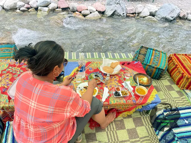
Lunch on Ourika river rapids at cascades of Sti Fadma waterfalls
Cascades de Setti Fatma, Ourika Valley

Finally arriving in Marrakech after a wonderful couple of days in Zanzibar, Tanzania, we traded an island for a walled city and, the next day, a mountain road. Marrakech came first; the Ourika Valley and Setti Fatma came next. It was a compact plan. Morocco had other ideas about scale.

The full map below covers our wider Morocco journey. This post stays with Marrakech and our day trip into the High Atlas foothills; the Full Map is there for anyone who enjoys zooming until geography starts filing complaints.

Marrakech & Ourika Valley, Morocco: Jemaa el-Fna, Ben Youssef Madrasa, High Atlas & Setti Fatma — Post Summary

After arriving by ONCF train from Casablanca, we spend two days in Marrakech, walking the Medina, Jemaa el-Fna, the souks, Ben Youssef Madrasa and the city’s tanneries before a wider city circuit past El Badi Palace, the Royal Palace, the Kasbah and Koutoubia Mosque. The next day takes us south on P2017 through the Ourika Valley to Oualmas and Setti Fatma, with an argan-oil mill, a traditional Amazigh house, a riverside lunch and the mountain waterfalls before we return to Marrakech.

What's Covered
🚆 Casablanca Airport to Marrakech by ONCF Train — Casa Oasis connection and Gare de Marrakech arrival
🧭 Marrakech Visitor Areas — Medina, Mellah, Gueliz, Hivernage and Menara
🕌 Jemaa el-Fna and Marrakech Medina — old-city arrival, square and riad
🛍️ Marrakech Souks — Semmarine, Zrabi, Haddadine and Chkayria
🎓 Ben Youssef Madrasa — courtyard, student rooms, carved wood, stucco and zellij
🧴 Marrakech Tanneries — leather workshops and the mint-branch “Moroccan gas mask”
🌙 Jemaa el-Fna After Sunset — night crowds, food stalls and the square after dark
🏛️ Marrakech City Circuit — El Badi, Kasbah, Bab Agnaou and Koutoubia
🏞️ Marrakech to the Ourika Valley — P2017 into the High Atlas foothills
🌰 Oualmas to Setti Fatma — argan oil, traditional Amazigh house, riverside lunch, waterfalls and return
Share
Tweet
Pin
Older Posts

Destinations

  • Andorra(3)
  • Austria(5)
  • Bahamas(1)
  • Bolivia(3)
  • Bosnia & Herzegovina(4)
  • Bulgaria(3)
  • Canada(3)
  • Chile(2)
  • China(9)
  • Croatia(7)
  • Czech Republic(2)
  • Dominican Republic(1)
  • Egypt(1)
  • France(6)
  • Georgia(8)
  • Germany(4)
  • Greece(5)
  • Hungary(2)
  • Iceland(3)
  • India(9)
  • Italy(6)
  • Jamaica(1)
  • Japan(1)
  • Kazakhstan(2)
  • Kyrgyzstan(2)
  • Mexico(4)
  • Mongolia(3)
  • Morocco(11)
  • Nepal(2)
  • North Macedonia(3)
  • Panama(1)
  • Peru(2)
  • Russia(5)
  • Serbia(3)
  • Slovakia(2)
  • Slovenia(4)
  • Spain(7)
  • Switzerland(4)
  • Tajikistan(2)
  • Tanzania(3)
  • Turkey(6)
  • Turkmenistan(7)
  • Ukraine(2)
  • United Arab Emirates(1)
  • United Kingdom(3)
  • United States of America(35)
  • Uzbekistan(2)
  • Zimbabwe(1)
Get new posts by email:
Powered by follow.it

Subscribe via RSS

RSS Feed »

Pages

  • Home
  • Ask Anything
  • About Us & Contact
  • Privacy Policy

© 1997 - The Vagabond Couple Travel Blog. All rights reserved.
Text, images, audio and video in The Vagabond Couple Travel Blog are © The Vagabond Couple.
. Powered by Blogger.
↑Back to top