Morocco: Merzouga to Fes Desert Road over High & Middle Atlas Mountain Ranges via Ziz Valley, Al-Hassan Addakhil Lake, Zaabal Tunnel, Enzala Mosque, Midelt, Boulajoul, Monkey Park & Ifrane
 |
| National Highway N13 near Zebzat: Where the road becomes a line drawn by geological forces |
We overnighted in a tent beside towering wind-blown sand dunes of Erg Chebbi in Great Sahara desert (long story at The Great Sahara of Morocco: Canyons of Todra Gorge, Farm on Tinghir Oasis, Amazigh Carpets and Riding Camels Over Merzouga High Erg Chebbi Dunes to Desert Camp Deep in Ocean of Orange Sand). In this photo story we start the day early at sunrise to ride camels back to Merzouga. We then drive to Fes crossing High Atlas and Middle Atlas mountain ranges across Ziz Valley, Al-Hassan Addakhil Lake, Zaabal Tunnel, Enzala Mosque, Midelt, Boulajoul (for lunch), the Monkey Park and Ifrane.
This journey represents one of Morocco's most dramatic geographical transitions - from the Sahara Desert at around 800 meters elevation to the High Atlas passes at over 2,000 meters, then descending to Fes at about 400 meters. We're essentially driving through multiple climate zones and geological provinces in a single day. The road itself, National Highway N13, is a feat of engineering that stitches together landscapes that nature spent millions of years pulling apart.
Here is a complete map of our expedition across Morocco, though this post only covers the drive on Merzouga to Fes desert highway. What's fascinating about this route is how it follows ancient trade paths used by caravans carrying salt, gold, and slaves between Timbuktu and Mediterranean ports. Today it carries tourists, minerals, and agricultural products, but the fundamental purpose remains the same: connecting the resource-rich south with the population centers of the north.
The map doesn't do justice to the vertical drama of this journey. We'll climb from the desert floor, where temperatures can hit 120°F (49°C), to mountain passes where snow can fall even in July, then descend into the temperate plains around Fes. It's like driving from Arizona to Colorado to Tuscany in eight hours, with better food at the rest stops.
Sunrise camel ride: Returning from Sahara Desert Erg Chebbi dunes camp to Merzouga
July 15, 2023
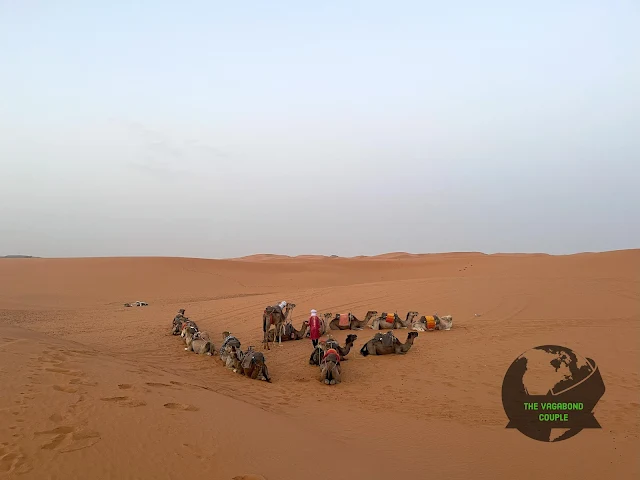
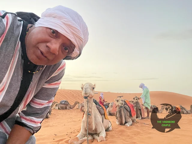
We wake up in our tent before sunrise and have a sumptuous breakfast in our Sahara desert camp in wind-blown 1,100 foot Erg Chebbi sand dunes. We are back on camels by 6:10 AM heading back to the little town of Merzouga. The Erg Chebbi dunes are actually a geological anomaly - these 1000-foot-tall dunes shouldn't exist this far north in the Sahara. They're essentially fossil dunes, formed by unique wind patterns that push sand from Algeria's Grand Erg Oriental northward. We're riding over what amounts to a sandy mountain range that's constantly on the move, reshaping itself with every windstorm.
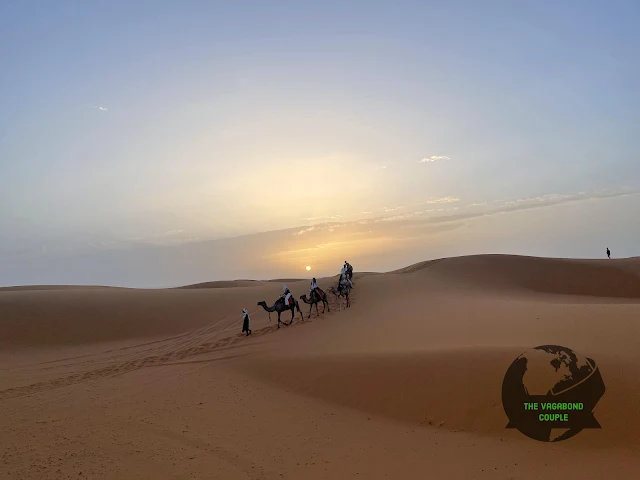
Sunrise over Erg Chebbi: The first light hitting 1,100-foot dunes creates a painterly landscape
The camel ride back is significantly more comfortable when you're not desperately clinging on while wondering if you'll ever walk normally again. We've got our camel-riding sea legs now, or more accurately, our desert-swaying rhythm. Our guide Ahmed tells us the camels actually have distinct personalities - some are grumpy morning camels, some are overachievers who want to lead the caravan, and ours seems to be the laid-back stoner camel of the group. He moves with a "we'll get there when we get there" philosophy that's actually quite zen.
Rayleigh scattering ensures a unique pink and orange colorscape of the Sahara and its dunes light of the dawn. This is the same physics that makes sunsets red, but in the desert with zero humidity and pristine air, the effect is magnified tenfold. The colors shift from deep violet to cotton candy pink to fiery orange in about 20 minutes - it's like nature's most extravagant Instagram filter, but completely natural and way more impressive in person.
The physics of beauty: Rayleigh scattering creates Saharan sunsets that painters can't quite capture
The silence of the desert at sunrise is its own kind of music. With no cars, no people, just the soft crunch of camel feet in sand and the occasional breeze whispering across dune crests. This is what people mean when they talk about "desert magic" - it's not mystical so much as it's a complete sensory reset. Your brain, used to constant stimulation, suddenly has nothing to process but beauty and quiet. It's mildly terrifying at first, then profoundly peaceful.

Caravan geometry: The line of camels follows ancient dune paths used for centuries
The indigenous Amazigh (Berber) people have been navigating these dunes for millennia without GPS or even compasses. They read the sand like sailors read waves - the shape of dune crests, the pattern of ripples, even the way sand sounds underfoot tells them where they are. Our guide points out landmarks we'd never notice: a particular rock formation, a subtle change in sand color, the way certain plants grow only on specific dune faces. It's a living topographic map written in a language we're only beginning to decipher.
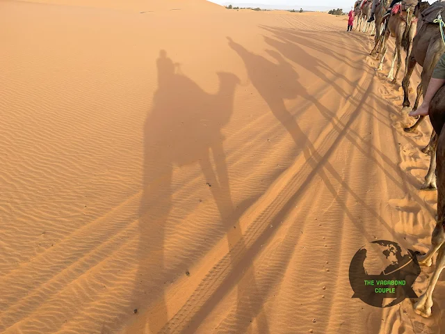
Desert engineering: Camel feet are natural snowshoes for sand, spreading weight perfectly
Every step our camel takes sinks several inches into the sand, which seems inefficient until you realize it's actually brilliant desert engineering. The broad, padded feet spread their weight like natural snowshoes, preventing them from sinking too deep. Meanwhile, we humans would be post-holing up to our knees with every step. The camels move with a rolling gait that conserves energy - they're basically the hybrid vehicles of the desert, optimized for fuel efficiency (in their case, water and forage) over millions of years of evolution.

The scale is deceptive: Those tiny dots ahead are other camels on 100-foot dunes
Looking back at our camp disappearing behind dunes gives us serious Lawrence of Arabia vibes, minus the political complications and questionable fashion choices. The desert has this way of making human endeavors look both brave and ridiculously temporary. Our camp, which felt so substantial last night, now looks like a child's sandcastle that the tide (or in this case, the wind) could erase in hours. It's a humbling perspective shift that city life never provides.
Transition time: The last stars fade as the desert prepares for another 120°F day
The temperature is rising noticeably even in this early light. In the Sahara, dawn isn't a gentle awakening - it's the opening act for a solar furnace performance. The air goes from pleasantly cool to "where did I put my sunscreen?" in about 30 minutes. Our guide explains that the sand actually heats up faster than the air, so walking on it barefoot becomes impossible by 8 AM. The camels don't seem to mind - their feet are so thickly calloused they could probably walk on hot coals. Another evolutionary win for Team Camel.
 |
| Sunrise Camel Ride: Erg Chebbi Sand Dunes to Merzouga, Sahara Desert - The entire caravan visible against the morning sky |
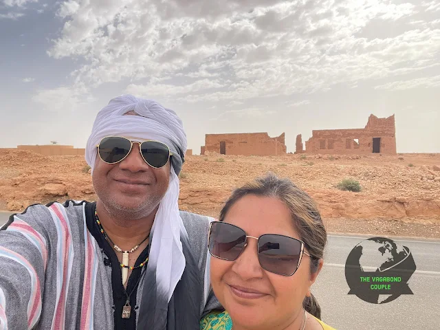
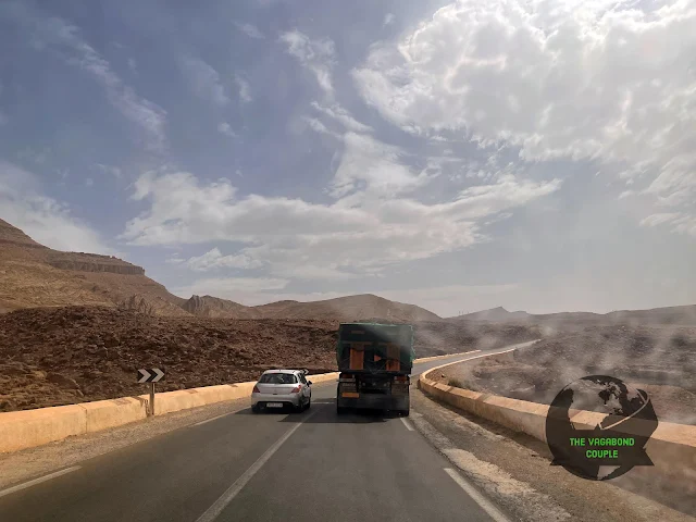
We bid our camels adieu and get in a modern automobile. The transition from 6th century transportation to 21st century air conditioning takes about 30 seconds but feels like time travel. Crossing Merzouga gate (Arch of Merzouga) and the town, we are back on Route R702 heading north to Erfoud. From Erfoud, we get on northbound National Highway N13. N13 starts just short of Algeria-Morocco border and connects Merzouga to big northern cities of Azrou and Meknes eventually meeting highway N2 just south of Chefchaouen. N13 intersects Highway N8 At Azrou, which will ultimately take us to Fes in the evening.
The N13 is essentially Morocco's spinal cord through the desert - a vital artery that connects the mineral-rich south with the population centers of the north. Built largely during the French protectorate, it follows ancient caravan routes that have been used for trade since Roman times. The modern road is a marvel of engineering that crosses multiple climate zones, from hyper-arid desert to fertile valleys to mountain passes, all in one day's drive.
 |
| Arch of Merzouga: The gateway between civilization and the sea of sand |
The Arch of Merzouga isn't just decorative - it marks a psychological boundary. On one side: the predictable world of towns, roads, and schedules. On the other: the Sahara, where nature sets the rules and humans are temporary guests. For centuries, passing through this gate meant entering a different reality where survival wasn't guaranteed. Today it's mostly a photo op, but you can still feel the symbolic weight. It's like passing through airport security into another country, except the country is 3.6 million square miles of sand.
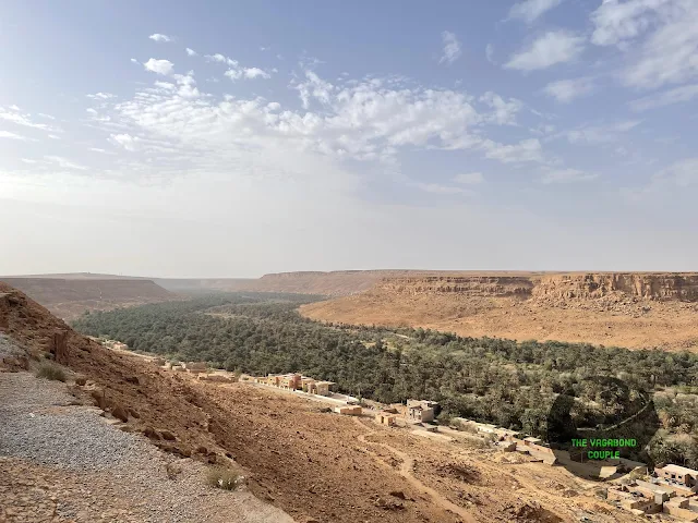
Ziz Valley
We cross Erfoud where we had previously picked up dates, and head north on N13 along the Ziz valley. The stretch of N13 highway between Erfoud and Midelt runs parallel to Oued Ziz (River Ziz) for over 125 miles. This river is literally the lifeblood of southeastern Morocco - without it, this entire region would be uninhabitable desert. The Ziz originates in the High Atlas mountains, fed by melting snow, and performs a miracle of hydraulic engineering as it carves through 200 miles of desert to create this improbable green corridor.
We stop for a coffee at one of the panoramic overlooks of the valley in Ouled Chaker. In the vast hamada of the Sahara stretching to the horizon, a narrow lush green belt irrigated by water of the Ziz along with geometric agricultural plots and settlements of Moroccan-style mud houses make for a striking landscape. The contrast is so dramatic it looks Photoshopped - like someone took a strip of Amazon rainforest and dropped it into the middle of Mars.
 |
| Ziz Valley: Where river meets desert in one of North Africa's most dramatic landscapes |
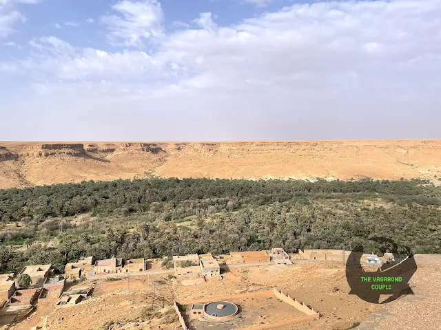
The Ziz valley has the highest concentration of date palm trees in Morocco. It is like a long oasis where farmers also grow a myriad of crops. What's fascinating is the agricultural intelligence here - they practice what's called "layered farming" or "oasis agriculture." Date palms form the top layer, providing shade for fruit trees (oranges, lemons, pomegranates) beneath them, which in turn shade vegetable crops at ground level. It's vertical farming invented a thousand years before Silicon Valley "discovered" it.
Agricultural chessboard: Each square is carefully irrigated from the life-giving Ziz River
The irrigation system is a masterpiece of low-tech engineering. They use a system called "khettara" - underground channels that tap into groundwater without pumps, using gravity alone. Some of these tunnels are centuries old and maintained by cooperative water user associations that have been operating since medieval times. It's democratic water management that would make California water wars look like amateur hour.

Architecture that breathes: Mud brick houses stay cool in 120°F heat naturally
The mud brick houses (called "ksour" in the singular, "ksar" for the fortress-like communal versions) aren't just quaint - they're brilliantly adapted to the environment. The thick walls provide thermal mass, keeping interiors cool during blistering days and warm during chilly desert nights. The small windows minimize heat gain. And when a house eventually deteriorates (after maybe 100 years), it literally returns to the earth it came from. This is sustainability so elegant it makes LEED certification look like overcomplicated paperwork.
Liquid geometry: Water distribution follows mathematical precision honed over generations
Our guide Ahmed explains that each family has water rights based on ancient agreements, sometimes measured in minutes of flow rather than volume. There's a water master ("amghar n waman") who oversees distribution using a sundial or water clock. Disputes are rare because the system has been perfected over centuries - it's common law written in water instead of paper. Try getting that level of consensus at your local homeowners association meeting.
 |
| Ziz Valley: A 125-mile-long miracle of water in the world's largest hot desert |
We are the only customers at the cafe, possibly due to Morocco still recovering from effects of the pandemic on tourism. The owner, Mohammed, tells us business is maybe 30% of pre-2020 levels. He's philosophical about it - tourism has always been cyclical in the desert. There were lean years during various regional conflicts, good years when European economies were strong. "The desert teaches patience," he says, pouring our coffee with the careful ceremony of someone who has all the time in the world. Which, out here, you sort of do.
 |
| Café Restaurant Vue Panoramique, Ziz Valley: Best view in Morocco, currently underappreciated |
The coffee is strong enough to wake the dead, which is appropriate since we're looking at a landscape that geological forces tried to kill for millions of years. The Sahara wasn't always desert - during the African Humid Period (about 11,000-5,000 years ago), this was green savannah with lakes and rivers. Climate change (the natural kind) turned it into desert. Looking at the Ziz Valley today is like seeing the last stubborn remnant of that greener past refusing to surrender.
Road engineering poetry: N13 follows the valley's contours like it was drawn with a calligraphy pen
We proceed north on N13 from the Ziz Valley scenic overlook towards Hassan Addakhil dam. The road construction here is impressive - it clings to mountainsides, tunnels through rock, and bridges across ravines with what seems like casual bravery. Our driver Ibrahim explains that maintaining this road is constant battle against geology. Flash floods can wash out sections, rockfalls are common, and the extreme temperature variations (from freezing nights to 120°F days) expand and contract the asphalt until it cracks. Road maintenance crews here deserve hazard pay and probably therapy.
 |
| National Highway N13 at Ouled Chaker in Ziz Valley: Where engineering meets 250-million-year-old geology |
The rock layers exposed by road cuts tell a story 250 million years in the making. You can see the transition from marine sediments (when this was underwater) to desert deposits (when it was, well, desert even before it was the Sahara). It's like reading Earth's diary, if Earth were a meticulous record-keeper who documented every climate change episode with sedimentary precision. Geologists probably have orgasms driving this road. The rest of us just think, "Cool rocks."

Geological time machine: Each switchback takes us further back in Earth's history
We're gaining elevation steadily, leaving the true desert behind. The vegetation changes almost imperceptibly at first - a few more thorny bushes, then the occasional hardy tree, then suddenly we're in proper forest. It's like watching a nature documentary in reverse fast-forward: desert → semi-desert → steppe → woodland. The temperature drops noticeably too - we've gone from Saharan blast furnace to pleasantly warm. Our bodies, which had adapted to the desert heat over days, now feel strangely cold at what the thermometer says is 75°F. Human adaptability is both impressive and ridiculous.
 |
| Highway N13 at Ziz Valley towards Al-Hassan Addakhil Dam & Reservoir: Leaving the desert, entering the mountains |
Hassan Addakhil Lake
Driving northbound N13, we cross the town of Errachidia. About six miles later we see the Hassan Addakhil lake. The sight is surreal - a massive blue lake in the middle of desert mountains, like someone Photoshopped Lake Tahoe into a Mad Max landscape. The contrast between the deep blue water and the rusty red mountains is so visually jarring it takes a moment to process.
Hassan Addakhil is an artificial lake formed as the reservoir of Hassan Addakhil dam (Barrage Al-Hassan Addakhil) on Ziz river. The dam was inaugurated in 1971 with the goal of controlling Ziz river flow and flood protection for irrigation and land use in Ziz valley. Hydroelectric power generation is also a benefit of this dam. Curiously, the dam initially leaked water and steps to fix the problem have been taken.
What's fascinating about this dam isn't just its engineering (impressive as that is), but its geopolitical significance. Built shortly after independence, it was Morocco's declaration of technological self-sufficiency - a statement that they could undertake massive infrastructure projects without colonial assistance. The dam created not just a reservoir but national pride. Though the leakage issue was embarrassing, fixing it became a point of national engineering pride.
 |
| Hassan Addakhil Reservoir: Where 1970s engineering meets million-year-old geology |
The reservoir holds about 400 million cubic meters of water when full - enough to supply a city of 4 million people for a year. In the desert, that's not just infrastructure; it's security, sovereignty, and survival. The dam also regulates the Ziz's temperamental flow - the river can go from a trickle to a raging torrent in hours when mountain storms hit. Before the dam, flash floods would regularly wipe out downstream farms. Now, the water is metered out like precious liquid gold.
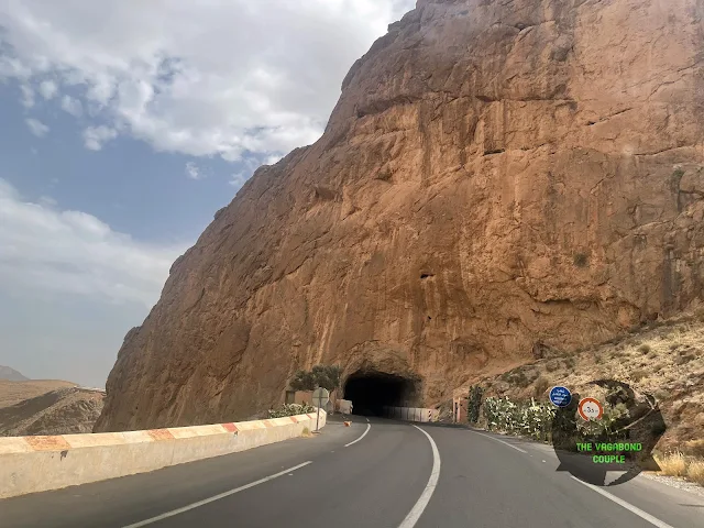
Zaabal Tunnel
We continue across the High Atlas mountain range along Oued Ziz and pass through Foum Zabel tunnel on northbound National Route 13. This tunnel was built by French colonizers in the 1920s and is also called the tunnel of Legionnaire after a French legionnaire who died during construction.
The tunnel represents colonial engineering at its most ambitious and brutal. Built with manual labor in an era before modern machinery, it claimed numerous lives (hence the name "Tunnel of the Legionnaire"). The French needed this passage to move troops and supplies between their northern strongholds and Saharan territories. Today it serves tourism and commerce, but you can still feel the ghost of colonial ambition in its cool, dark interior.
Gateway to the other side: Zaabal Tunnel cuts through what was once an impassable barrier
Entering the tunnel feels like passing through a geological time portal. The rock here is some of the oldest in Morocco - part of the African Craton that's been stable for over a billion years. The tunnel engineers had to deal with complex geology including fault lines and unstable rock layers. That they managed it with 1920s technology is either impressive or terrifying depending on how much you trust century-old engineering.
 |
| N13 North to Zaabal Tunnel: Where the road becomes one with the mountain |
Part of today's N13 highway essentially overlaps a trans High Atlas road constructed by the French connecting the city of Midelt north of the High Atlas to Errachidia south of the mountains. This was military infrastructure repurposed for peace - a common theme in post-colonial Morocco. Many of the country's best roads started as French military routes designed to control rebellious regions. Today they connect those same regions to economic opportunity. History's irony department works in mysterious ways.
Tunnel mouth geology: Each rock layer tells a different chapter of Morocco's formation
The tunnel interior is surprisingly elegant for something built a century ago. The arched design isn't just aesthetic - it distributes the mountain's weight perfectly. There are no reinforcements or steel beams, just carefully shaped stone holding up millions of tons of rock. It's architecture that understands stone's language - working with its strengths rather than fighting against them. The French engineers might have been colonizers, but they were damn good stone whisperers.
 |
| South entrance to Zaabal (Foum Zabel) tunnel, National Route 13 (N13): 1920s engineering still going strong |
Emerging from the tunnel's north side feels like entering another world. The landscape transforms abruptly - we've crossed the geological divide between the Sahara's domain and the Atlas Mountains' territory. The air is cooler, the vegetation greener, and the rock formations change from sedimentary layers to volcanic and metamorphic rocks. We've literally driven through a mountain and come out in a different Morocco.
Crossing the Ziz River
After exiting the tunnel, we continue north on highway N13 towards Ait el abbas and shortly cross a bridge on the great Ziz river of Morocco. The village of Ait Boudaud is right across on the other side of the bridge.
This bridge represents more than just a river crossing - it's where the Ziz completes its transformation from desert life-giver to mountain stream. Upstream, it's fed by snowmelt and springs; downstream, it gives life to the Ziz Valley; here, it's transitioning between those identities. The water is clearer and colder here, having filtered through kilometers of mountain rock. If rivers have personalities, the Ziz here is the vigorous, youthful version before it assumes the solemn responsibility of sustaining desert agriculture.
 |
| Ziz River Bridge: Where mountain stream becomes desert lifeline |
The villages here are built with defensive positioning in mind - perched on hillsides with clear views of approaching travelers. This region was historically contested between various Amazigh tribes, and village architecture reflects that martial history. The houses cluster together for mutual protection, with few ground-floor windows and easily defensible positions. Today the threats are gone, but the architectural DNA remains, creating villages that look like they grew organically from the rock itself.
Enzala Mosque (Mosquée Enzala)
After crossing the Oude Ziz bridge, we cross this pretty mosque on the east side of northbound N13 in the small town of Enzala.
The Enzala Mosque is a perfect example of rural Moroccan religious architecture - simple, functional, and beautiful in its geometric purity. Unlike the ornate mosques of cities like Fes or Marrakech, rural mosques serve smaller communities and reflect local materials and traditions. The minaret here isn't towering - it's just tall enough for the call to prayer to reach nearby homes. The design follows traditional proportions that have been used for centuries, creating a building that feels both ancient and timeless.
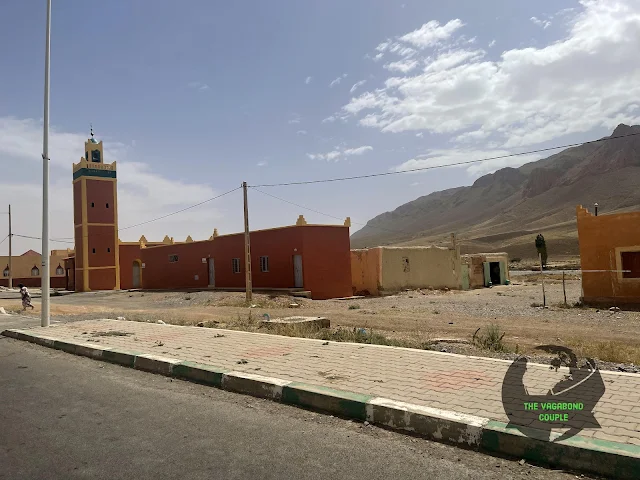
Enzala Mosque: Islamic geometry meets mountain pragmatism
What's fascinating about rural Moroccan mosques is how they incorporate pre-Islamic building wisdom. The thick walls provide thermal mass for temperature regulation, the orientation maximizes natural light while minimizing heat gain, and the materials (local stone and plaster) are both sustainable and durable. This isn't just a place of worship; it's a climate-adapted building that represents centuries of accumulated architectural intelligence.
 |
| Mosquée Enzala, Highway N13, Enzala: Rural religious architecture at its most elegant |
The mosque's presence right beside the highway is no accident. In traditional Moroccan planning, important community buildings are placed along travel routes to serve travelers as well as locals. This mosque likely provides spiritual services for truck drivers, tourists, and locals alike. It's a reminder that in Morocco, religion isn't separate from daily life or travel - it's woven into the fabric of movement and community.
Midelt
Midelt is a city of 55,000 in middle of the Moroccan altiplano between Middle Atlas and High Atlas ranges. At an altitude of just shy of 5,000 feet, Midelt is just south of the Hassan II dam and reservoir (Barrage Hassan II) on Moulouya river (Oued Moulouya). Midelt is one of Morocco's major mineral mining and agricultural hubs.
What makes Midelt geologically fascinating is its position at the confluence of three major geological provinces: the Sahara Platform to the south, the High Atlas mountains to the north, and the Middle Atlas to the west. This creates incredible mineral diversity - the region produces lead, zinc, copper, silver, and beautiful mineral specimens that collectors worldwide prize. The mountains here aren't just scenic; they're literally made of valuable rocks.
Reaching Midelt implies we have now crossed the High Atlas mountains and the Middle Atlas Mountains are coming up on our road. We've completed what was once a perilous journey through the Atlas passes - a route that took caravans weeks and now takes us hours. The psychological shift is palpable: we're leaving the Sahara's domain and entering the more temperate, populated north of Morocco.
We cross the traffic circle on highway N13 at Midelt (Rond-point Imilchil Midelt). National Route 13 heads generally west and northwest towards Azrou at this point. This traffic circle is more than infrastructure - it's a symbolic crossroads. One road leads back to the desert we came from, another toward the mountains ahead, another to mining areas, and another to agricultural zones. Midelt sits at the intersection of Morocco's economic and geographical identities.
 |
| Midelt Traffic Circle on Highway N13: Where desert, mountains, and agriculture meet |
The agricultural transformation here is remarkable. We've gone from date palms in the Ziz Valley to apple orchards around Midelt. The cooler climate at this elevation allows for temperate fruits that won't grow in the desert. Midelt is particularly famous for its apples - crisp, sweet varieties that thrive in the mineral-rich soil. It's a perfect example of altitudinal zonation: different elevations create different microclimates suitable for different crops. The Amazigh farmers have been exploiting this vertical geography for centuries.
Boulajoul
It is exactly 12:30 PM when we reach Boulajoul a bit northwest of Midelt. It is a great time to stop for lunch. The name "Boulajoul" sounds like it should be a character in a fantasy novel rather than a lunch stop, but here we are. The town has that peculiar roadside settlement energy - existing primarily because travelers need to eat and rest between more important places.
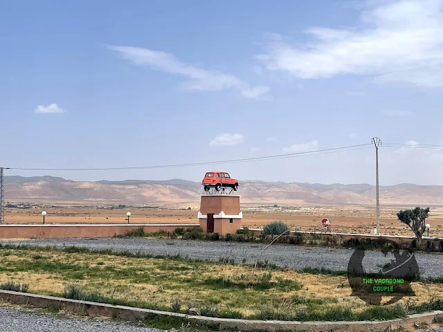
Hotel Meteorites Boulajoul: Where roadside kitsch meets genuine hospitality
We have lunch at Hotel Meteorites Boulajoul. Traditional Amazigh hospitality again makes lunch and interaction with locals a joy. Meteorites cannot be missed from highway N13; it has a red car perched on a tower at one of the corners of its large walled property. The car-on-a-stick is either brilliant marketing or someone's creative solution to having a broken-down car and a tall pole. Either way, it works - you can't not notice it.
 |
| Hotel Meteorites Boulajoul entrance: Traditional Moroccan architecture meets roadside Americana |
We are still going strong on Moroccan staples tagine and couscous. The price of a three course meal is still exactly the same as everywhere else: roughly US$ 13. This price consistency across remote Morocco is either a remarkable example of informal price fixing or proof that $13 is the universal "fair price for a good meal" conversion rate. Either way, we're not complaining - for that price in New York, you'd get a sad sandwich and judgment from the cashier.
 |
| Tagine and Couscous for lunch (again!): When in Morocco, eat as the Moroccans do. Repeatedly. |
We are still dressed for the desert camel ride and do not miss any opportunity to show off our newly learned Amazigh sign of peace and wellbeing. We are told by multiple locals we could pass ourselves off easily as Moroccans from Agadir. This is either genuine compliment or polite Moroccan hospitality, but we're choosing to believe it's the former. The hand gesture - thumb and pinky extended, other fingers folded - looks like a heavy metal salute but means "peace, health, and blessings." It's basically the opposite of "rock on," which is confusing for anyone raised on 80s metal.
 |
| Amazigh hand sign of peace, health and blessings: Not to be confused with "rock on" |
Monkey Park
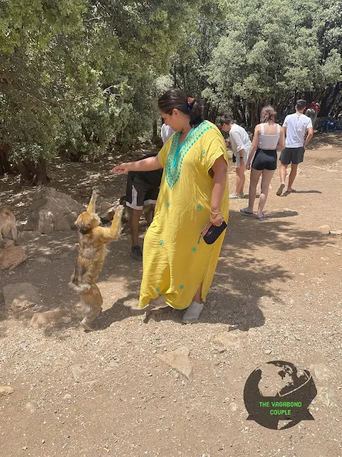
We are soon on the Middle Atlas mountains. Our next stop is a Monkey Park a few miles before the city of Azrou. The change in landscape is dramatic - we've left the desert completely behind and entered a world of green forests and cool mountain air. The road winds through cedar forests so dense they create their own microclimate. The air smells of pine and damp earth instead of dust and heat.
The Monkey Park is at the south end of Atlas Cedar Biosphere Reserve (Reserve naturelle de cèdres) that is a UNESCO Biosphere Reserve. Three-quarters of magnificent Atlas cedar trees are endemic to this reserve which has 12,000-foot mountains of the Middle Atlas range providing water for rich ecosystems. A million indigenous Amazigh people also live inside the reserve strongly holding up nomadic and non-nomadic traditions.
The Barbary macaques here are the only wild primates in North Africa (excluding humans, though sometimes that's debatable). They're actually apes, not monkeys, which makes the name "Monkey Park" technically inaccurate but easier for tourists to remember. These macaques have been here since the last Ice Age when forests covered much of North Africa. As the climate dried and the Sahara formed, they retreated to these mountain refuges where the cedar forests maintained enough moisture to survive.
Barbary macaque: North Africa's only native primate, judging us appropriately
The cedar trees themselves are living history. Some are over 800 years old - meaning they were saplings when the University of Al Quaraouiyine in Fes (the world's oldest continuously operating university) was already 300 years old. They've witnessed the rise and fall of empires, climate changes, and now tourists with smartphones. Their wood is aromatic and insect-repellent, making it incredibly valuable. The Roman Empire nearly logged them to extinction for shipbuilding; today they're protected, but climate change poses new threats.
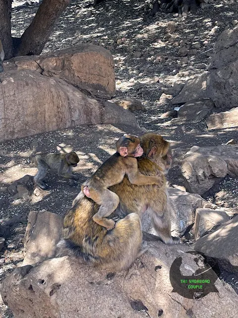
Barbary macaque family: Social structures similar to human families in the cedar canopy
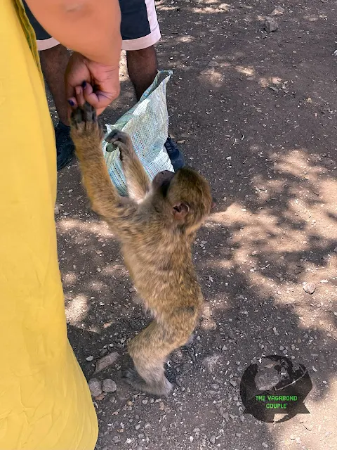
These macaques have a complex social structure that researchers have been studying for decades. They live in troops of 10-30 individuals with a clear hierarchy, social grooming rituals, and even what appears to be conflict resolution behavior. Watching them interact is like watching a nature documentary about your own family, if your family spent all day picking bugs out of each other's fur and stealing tourists' snacks when they're not looking.
Ancient Atlas cedar: A living witness to 800 years of Moroccan history
The Atlas cedar (Cedrus atlantica) is a true survivor. These trees have adapted to survive wildfires (their thick bark protects them), drought (deep taproots), and extreme cold. The wood contains natural fungicides and insecticides, which is why it's been prized for centuries for building and furniture. The scent alone - a rich, spicy, pine-like aroma - is enough to make you understand why people would fight wars over access to these forests.
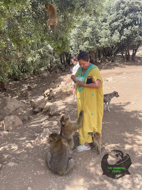
Observer and observed: Macaques study tourists as intently as we study them
There's a strange reciprocity to wildlife watching here. As we observe the macaques going about their daily lives - grooming, playing, foraging - they're equally observing us. You can see them calculating risk vs. reward: "Is that tourist likely to have food? Are they aggressive? Should we approach or flee?" It's a reminder that in these protected areas, we're the interlopers in their world, not the other way around.
Ifrane
Switzerland of Morocco
We take the exit off highway N13 for National Route N8 towards Ifrane and Fes right after the north end of Atlas Cedar Biosphere Reserve. Ifrane is not too far from here. The transition is startling - we go from wild cedar forest to something that looks like it was airlifted from the Alps. Ifrane is often called "Little Switzerland" or "Morocco's Switzerland," which seems both accurate and vaguely insulting to Morocco. Like, "Your country is beautiful, but this part reminds us of somewhere else we think is better."
The city of Ifrane is distinctly European in ambience. We see a number of vehicles with EU license plates. There is significant tourist traffic from across the strait of Gibraltar due to high-altitude cool climate and spectacular scenery. Michlifen Resort offers golf in the summer and ski slopes in the winter. It's a resort town that caters to Moroccans who want to experience Europe without leaving Morocco and Europeans who want to experience Morocco without leaving Europe. It's the diplomatic compromise of tourism.
We were literally ordered by locals to take a selfie with the iconic stone statue of a lion. This monument is dedicated to the last Atlas lion on Morocco that was shot and killed nearby. The Atlas lion or Barbary lion (or Egyptian lion) is an extinct subspecies. They were reportedly the biggest of lions. The last one was killed in 1922, which coincidentally is around when this tunnel was being built. Progress giveth (tunnels) and progress taketh away (lions).
Local legend says the sculptor of the stone lion was a WW-II German POW who was freed in exchange for carving this lion out of stone. It is also believed visiting and taking pictures with the stone Panthera leo leo brings good health, happiness and luck. So we take the photo, because who turns down free luck? Especially when it comes in lion-shaped form.
") |
| Lion of Ifrane: Stone memorial to what progress destroyed |
 |
| Outdoor seating in front of Chamonix Hotel, Ifrane: Where Morocco pretends to be Europe |
We continue on National Route 8 through Ifrane towards Fes. The road descends from the mountains toward the plains where Fes lies. With each kilometer, the temperature rises slightly, the architecture becomes less European and more traditionally Moroccan, and the traffic increases. We're leaving the rarefied air of mountain resorts and returning to the bustling reality of Moroccan urban life.

Transition landscape: The mountains release their hold as we approach the plains of Fes
On our way, we see an exit into the Fes-Taza-Oujda extension of Rabat-Fes A2 tolled expressway. With this extension, Morocco completed its first end-to-end ticket based toll road all the way from Rabat to Meknes, Fes, Taza and Oujda. This will be a great road for our next trip to Morocco. The toll road represents modern Morocco - efficient, connected, and forward-looking. But today we're taking the old road, the scenic route, the path that forces you to actually experience the country rather than just pass through it at 120 km/h.

Return to tradition: Farmland replaces resort architecture as we near Fes
But for now, we continue on the N8 to Fez. The landscape becomes increasingly agricultural - fields of wheat, olives, and vegetables replace the cedar forests. Villages become more frequent, traffic increases, and the signs of approaching city life multiply. We've come full circle from the empty spaces of the Sahara to the crowded reality of one of Morocco's great cities. The journey has covered not just distance but climate zones, cultures, and centuries of history.

Fes on the horizon: The spiritual capital emerges from the agricultural plains
 |
| National Highway N8 from Ifrane towards Fes: The final approach to Morocco's spiritual capital |
Fes - Fes el Bali
We are passing by the New Door of Fes by a quarter to 5 PM. Our riad in Fez is actually inside the historic walled old city medina of Fes - the legendary Fes el-Bali. The "New Door" is hilariously named considering it leads to a city founded in 789 AD. In Fes terms, "new" means "only a few centuries old." The door itself is actually a 20th century addition to facilitate car traffic into a city designed for donkeys and pedestrians. It's like adding a USB-C port to a medieval manuscript - functional but anachronistic.
 |
| New Door of Fes: The 20th century meets the 9th century (with traffic) |
Here is a video of the Morocco Sahara Desert and Atlas Mountains road trip from Merzouga to Fez.
Watch: Driving the Sahara Desert & Atlas Mountains of Morocco - Merzouga to Fes
Our story continues in Fes el-bali at "Fes El-Bali: We did not get fazed by the epic maze of Medina of Fez". From the silent dunes of the Sahara to the chaotic symphony of Fes's medina - we've traveled through landscapes, climates, and centuries. The road from Merzouga to Fes isn't just a highway; it's a timeline of Moroccan history, a cross-section of its geography, and a sampler of its cultures. We arrived with desert dust on our shoes and mountain air in our lungs, ready to get lost in the world's largest living medieval city. Spoiler: we did get lost. Repeatedly.
0 comments