
 |
| Antelope Canyon X — a shaft of midday light reached the sandy floor beside us. |
Part 14 ended in Page after our Grand Canyon drive along Desert View Drive, US-89, Antelope Pass and Horseshoe Bend. Page became our base for Glen Canyon Dam and Lake Powell, a Navajo-guided descent into Antelope Canyon X, and a long southbound loop past roadside murals and Sunset Crater before turning back toward Tuba City.
The map called this a short regional detour. The odometer, as usual, had read the fine print.
Trans-America Part 15 — Post Summary
Across three days based in Page, we visit Glen Canyon Dam and low-water Lake Powell, descend into Navajo-guided Antelope Canyon X, follow US-89 past the Painted Desert Project and Sunset Crater, then double back to Tuba City for Code Talker history, trading-post history and a market meal.
| What's Covered | |
| 💧 | Glen Canyon Dam and Lake Powell — reservoir engineering, low water and the flooded canyon |
| 🪨 | Antelope Canyon X — Navajo-guided descent into two slot sections |
| ☀️ | Inside Canyon X — Jurassic sandstone, flash floods and midday light beams |
| 🦎 | Desert Lizards — two small canyon residents, with no species guessing |
| 🎨 | Painted Desert Project — public art and community stories at Gray Mountain |
| 🌋 | Sunset Crater — the 1085 eruption and 2024 fire-recovery limits |
| 🥘 | Tuba City — Code Talkers, the historic trading post, fry bread and roast mutton |
| 🧭 | Next Stop — Monument Valley, Valley of the Gods, Goosenecks and Durango |
We drove Shehzadi roughly 340 miles over three days. Page served as our base for Glen Canyon Dam, Lake Powell and a Navajo-guided Canyon X tour. We then followed US-89 through Gray Mountain to Flagstaff, doubled back through Cameron, and took US-160 to Tuba City before returning to Page. Water engineering, flash-flood geology, public art, military history and roast mutton shared the route.
Method: Overland by truck plus a Navajo-guided Canyon X tour
Distance / Time: Approx. 340 miles / 3 days
Themes: reservoir engineering · slot-canyon geology · public art · Diné history and food
Vehicle: Shehzadi (2024 Toyota Tundra)
Route at a Glance
- Glen Canyon Dam and Lake Powell around Page
- Antelope Canyon X guided descent on Navajo Nation land
- Inside Canyon X for sandstone, flash-flood marks and light beams
- Two desert lizards near the canyon
- US-89 south to the Painted Desert Project at Gray Mountain
- Sunset Crater and the Flagstaff turnaround
- US-160 east to Tuba City for Code Talker history and lunch
- Return to Page before the Monument Valley leg
Glen Canyon Dam and Lake Powell
We began at Glen Canyon Dam, a 710-foot concrete arch across the Colorado River. Construction began in the late 1950s, Lake Powell started filling in 1963, and the dam was completed the following year. From the overlook, the downstream river looked narrow beside the walls and power lines. Scale made enormous infrastructure resemble desk furniture.
 |
 |
| Glen Canyon Dam The regulated Colorado downstream, the concrete arch and our group at the overlook. | |
Lake Powell can hold about 25 million acre-feet when full and ranks behind Lake Mead among U.S. reservoirs by storage capacity. Its long arms extend through former side canyons, producing about 1,960 miles of shoreline at full pool. During our visit, the white bathtub ring and broad exposed slopes made the missing water easier to see than the statistics.
 |
| Lake Powell — low water exposed a broad pale ring around the reservoir. |
A prolonged dry period had kept the reservoir far below full capacity for much of the century. We looked small above the exposed shoreline and its older high-water mark.
 |
 |
 |
 |
| Lake Powell overlook Shehzadi, exposed shoreline and our group above the reservoir. | |||
The lake carries the name of John Wesley Powell, the Civil War veteran and geologist who led the 1869 expedition down the Green and Colorado rivers. Lost instruments and records limited that journey’s scientific results, so a later expedition returned for fuller survey work. Engineers eventually regulated the river with concrete, turbines and several binders of serious paperwork.
The dam brought hydropower, storage and recreation. It also flooded Glen Canyon, where people had traveled, farmed and built for more than 10,000 years. Dam operations changed downstream sediment movement, while lower lake levels exposed ground that spent decades underwater. Blue water, pale rock and the giant dam showed the tradeoff in one view.
Rainbow Bridge lay beyond our route and is sacred to several affiliated tribes. Early records rendered one Navajo name, Nonnezoshe, closer to “rock that goes over” than “rainbow turned to stone.” Small translations can cause large accidents.
We returned to the marina near dusk. Boats sat below the exposed shoreline while the dock lights came on. The water darkened, the cliffs held the last orange light, and Page settled into evening. No Monet was harmed in describing it.
 |
 |
| Lake Powell marina at dusk One last look over the docks as lights came on. | |
Antelope Canyon X: Guided Descent
The next morning, we followed our Navajo tour operator to Antelope Canyon X. Navajo Nation Parks requires a guide at Antelope Canyon sites, so this was a managed visit rather than a free-range scramble through a drainage.
 |
| Entering Navajo Nation — the red sign was more direct than most visitor brochures. |
The broad desert surface hid the narrow world below.
 |
| Canyon X arrival — vehicles and visitors gathered above the slot-canyon entrance. |
Stairs and a sandy path descended through fine red sand.
 |
| Canyon X descent — stairs and a sandy path led below the desert surface. |
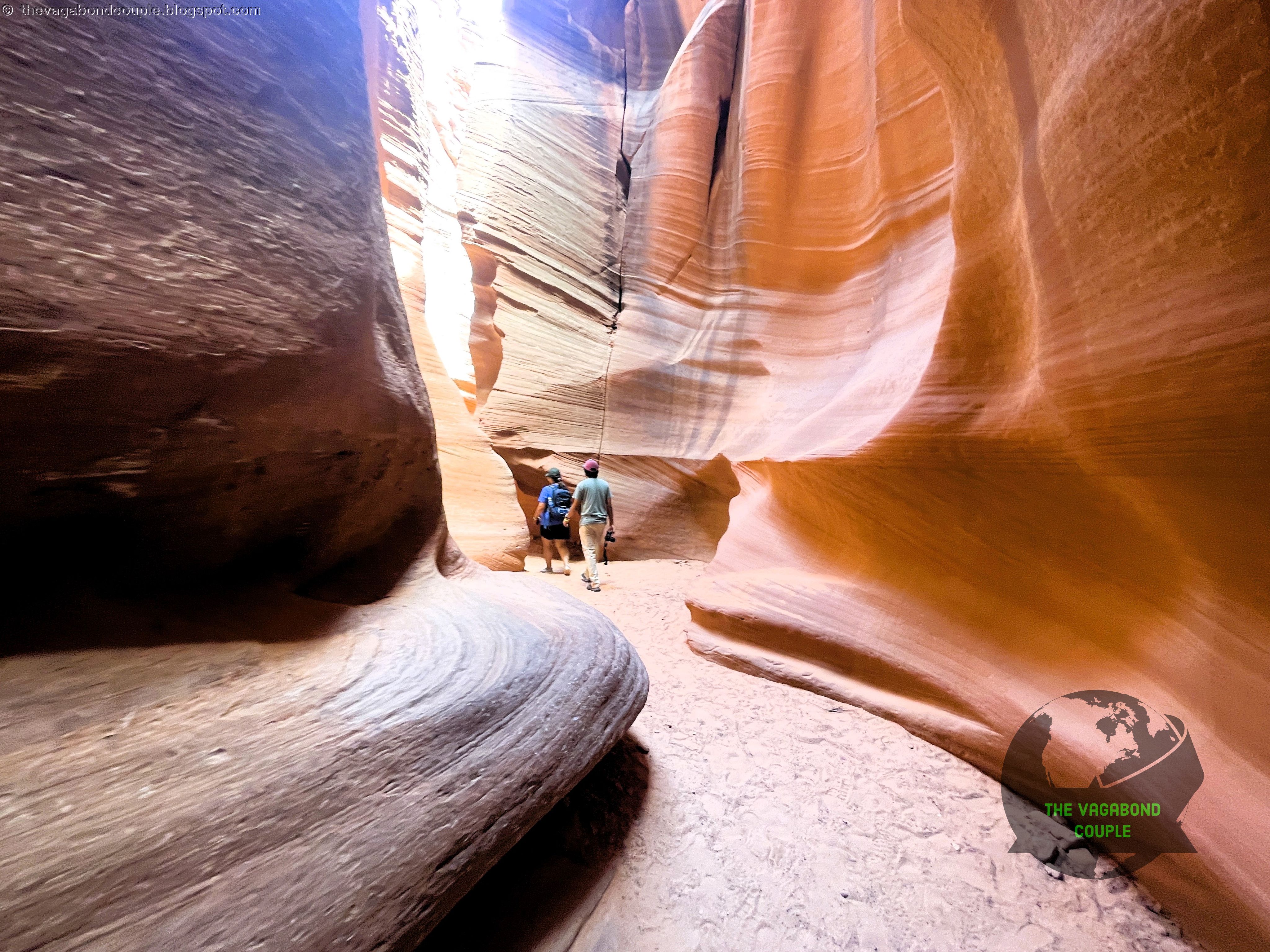
Canyon X belongs to the Antelope Canyon system southeast of Page. The tour reaches two slot sections separated by a short walk. Our guides called them Mother Canyon and Father Canyon; we retain those tour names without treating them as universal map labels. One opened into broad alcoves, while the other tightened into sharper bends.
 |
 |
 |
| Canyon X entrance passages The walls narrowed from broad curves to a close slot. | ||
The descent changed the scale quickly. Above, the canyon was a thin break in the desert. Inside, walls rose in polished folds and people became measuring sticks. The sand underfoot came through the drainage that carved the slot. It looked harmless because it was taking the day off.
Inside Canyon X: Light, Stone and Flash Floods
The walls are Navajo Sandstone, formed from Jurassic dunes and preserved with sweeping cross-beds. Fractures later gave runoff a path. Storm water and sediment grind, undercut and widen the narrow channels. Wind clears loose grains, but flash floods do the heavy lifting. This is a drainage with excellent lighting, not a sculpture studio.
 |
| Canyon X light beam — sunlight turned airborne dust into a visible column. |
Our guide pointed to flood marks high on the walls, some roughly 20 feet above the floor. That lived explanation mattered. Antelope Canyon’s beauty and hazard come from the same process, and a storm far upstream can send water into a slot where the local sky still looks innocent.
Midday light caught dust beneath openings above. The beams looked solid enough to lean on, a poor experiment. As the angle changed, the walls shifted from orange to pink and purple because reflected light from one wall painted the next. This was the Antelope Canyon X we had come to see.
 |
 |
 |
| Inside Canyon X Travelers, a crouching photographer and light reaching the sand. | ||
We moved through broad chambers, narrow turns and tall sections where the sky became a thin blue strip. Other visitors paused for photographs, crouched beside the beams or looked straight up until their necks filed complaints. The canyon’s scale worked best when a person appeared in the frame.
 |
 |
 |
| Canyon X scale Tall striated walls, a narrowing passage and one beam overhead. | ||
A wider view showed walls rising around two visitors.
 |
| Canyon X scale — people supplied the most useful measuring system. |
A sandstone shelf offered a brief seat and performed the basic furniture requirement.
 |
| Canyon X alcove — two of us rested on a sandstone shelf beneath the curved walls. |
Cross-bedded walls curled around a narrow strip of sky.
 |
| Canyon X ceiling — cross-bedded sandstone curled around a strip of blue sky. |
Our Navajo guides controlled the pace, explained the route and helped with photographs. We preserve that exchange without adding generic claims about spirits in every rock or wind granting camera permission. Water, stone, time and a good guide had already done enough.
Moving footage shows something still photographs struggle with: the walls keep changing as the viewer takes a few steps. A curve that looks flat from one angle opens into another corridor from the next.
A Navajo-guided video tour through Antelope Canyon X, from the descent to the midday beams.
Desert Lizards Near Canyon X
Two small lizards crossed our route near the canyon. One paused long enough for a photograph on pale sand.
 |
| Near Canyon X — a pale patterned lizard stopped on the sand. |
The second stopped on red sandstone and gave us a clearer view. We could not verify either species from the photographs, so we leave them as desert lizards rather than promoting them into an incorrect field guide. They appeared fully satisfied with this career level.
 |
| Near Canyon X — a small pale lizard paused on the warm red sandstone. |
Both soon disappeared into the larger geology.
Painted Desert Project at Gray Mountain
On the following morning, we drove south from Page on US-89. That highway had already appeared elsewhere in our expedition through Arizona, Utah and Idaho, and Wyoming and Montana. Near Gray Mountain, the road acquired walls covered in portraits, giant eyes, geometric forms, painted tanks and words about water and rain.
 |
| Painted Desert Project — the artist-list pillar identifies work across the roadside site. |
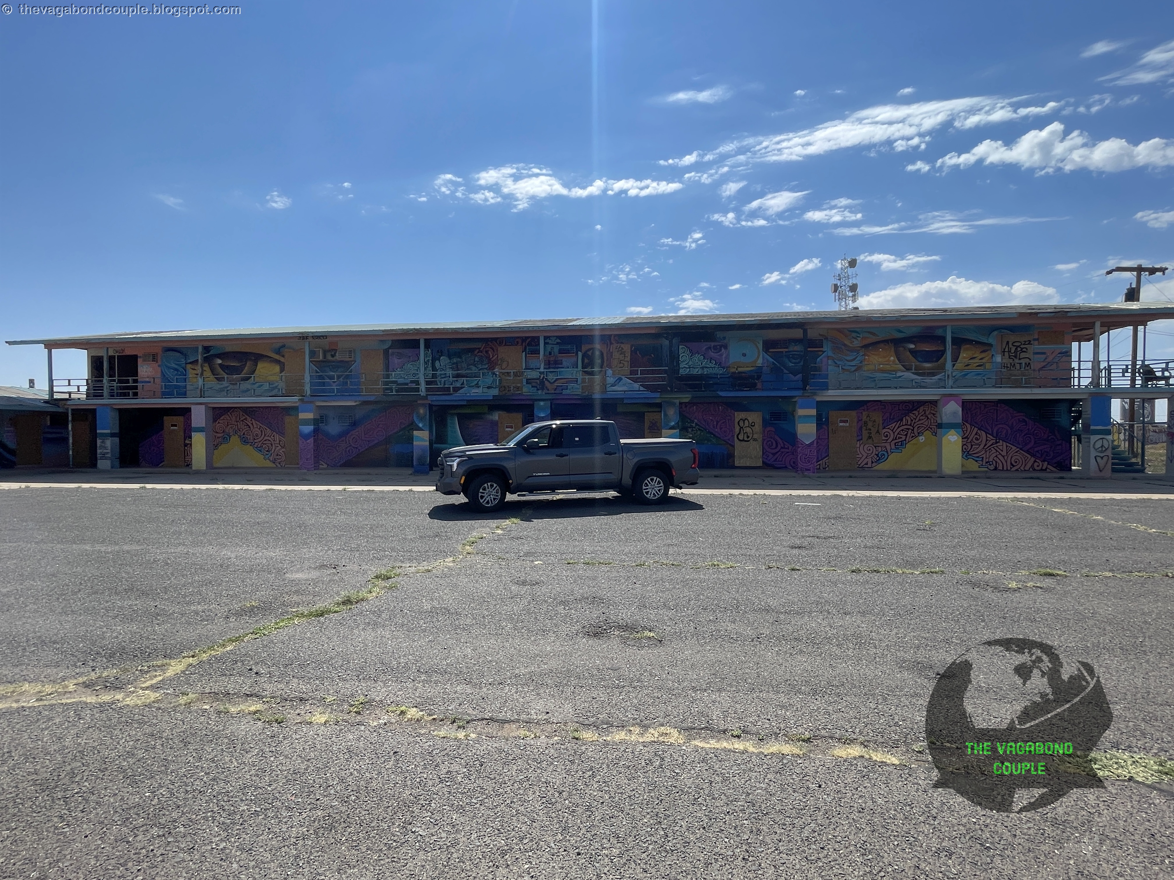
This was the Painted Desert Project, spread across a roadside complex on US-89 near Gray Mountain.
 |
| Painted Desert Project — the old complex stretches across a long mural-covered façade. |
Physician and artist Chip Thomas, also known as Jetsonorama, began placing large photographic murals across the Navajo Nation. Academic work reads the portraits as a response to older photography that treated Native people as disappearing subjects. His murals instead emphasize Diné presence, memory, health and community, even as desert weather removes the paper.
Local and visiting artists expanded the project. Murals address health, uranium mining, water, food access, family and community life across old buildings, tanks and walls. A site that once asked drivers to stop for fuel now asks them to pay attention. The second service may last longer.
 |
 |
 |
 |
 |
 |
 |
|
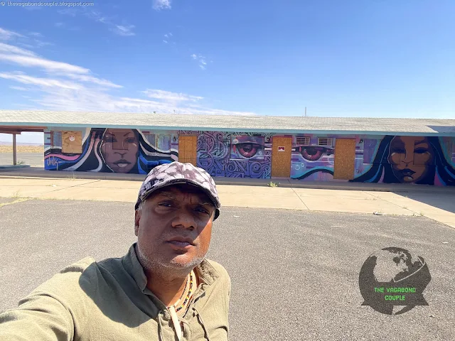
| Painted Desert Project at Gray Mountain Portraits, giant eyes, abstract forms and Shehzadi beside the old roadside complex. | |||
We photographed a change-themed portrait, huge eyes across a façade, abstract color and Shehzadi beside the buildings. The truck was temporarily promoted from expedition vehicle to art critic. Her review remained four tires out of four.
 |
| Water and rain — Diné words cover a wall beside the old gas-station canopy. |
Diné words for water and rain covered a wall beside the old canopy. Nearby tanks, geometric shapes and a small portrait building extended the project beyond a single style or message.
 |
 |
 |
| Painted Desert Project Painted tanks, a geometric wall and a small portrait building. | ||
Traffic, weathered walls and desert remained part of the work.
Sunset Crater and the Flagstaff Turnaround
Farther south, Sunset Crater rose near the San Francisco Peaks. The cinder cone formed during an eruption around 1085 CE, the youngest eruption in the San Francisco Volcanic Field.
 |
| Sunset Crater — the cinder cone rises behind its elevation sign. |
Thick cinders and lava made nearby ground unusable, forcing communities to relocate. Farther away, thin cinder deposits helped soil retain moisture and supported dryland farming. Volcanoes are capable of both eviction and agricultural consulting, though their bedside manner remains poor.
 |
| Near Sunset Crater — Shehzadi faced volcanic peaks beneath a summer storm. |
Fire-recovery work after the 2022 Tunnel and Pipeline fires limited access. In 2024, temporary restrictions remained while crews removed hazard trees. We saw the dark cone from the road rather than improving our trespassing résumé.
We reached the Flagstaff area, where US-89 meets Historic Route 66, then turned around. The source post had credited Route 66 with the whole run from Page, but our actual road south was US-89. Route 66 entered the day only at Flagstaff. Highways dislike being credited for each other’s work.
Tuba City: Code Talkers, Trading Post and Fry Bread
We drove north again through Cameron, then turned east on US-160 toward Tuba City. Signs for Coal Mine Canyon and dinosaur tracks passed along the route, but we did not visit those sites. The road crossed open Diné and Hopi country before reaching Tuba City, a community associated with the Hopi leader Tuuvi.
 |
| Tuba City — one of us at the community welcome sign. |
The truck paused between those two signs.
 |
| Tuba City — The truck paused between those two signs. |
Navajo Code Talkers and Tuba Trading Post
The memorial-highway names require care. US-89 honors Native American veterans, while this US-160 section is the Native American Women Veterans Highway. Nearby routes honor Navajo Code Talkers. The purposes overlap, but highway departments preserve the wording.
 |
| Navajo Code Talkers — the roadside sign lists wartime code words. |
At the Tuba City entrance, the Code Talker sign listed wartime code words, including Ne-he-mah, “Our Mother,” for America. The Marine Corps program began with a small group and grew to about 420 Navajo Code Talkers during World War II. Their voice code carried messages during Pacific campaigns and was never deciphered by the enemy.
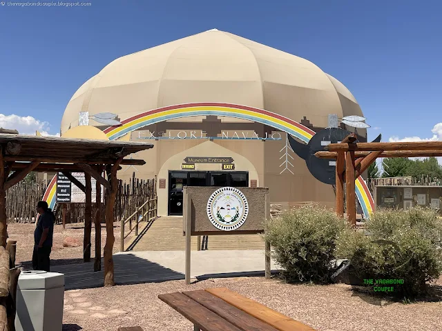 |
| Tuba City museum — entrance to the Navajo museum and visitor center. |
At the Navajo museum and visitor center area, we met a descendant of Code Talkers. He told us, “The Germans never cracked it. Our words were weapons.” We retain the quotation as his words. The operational history belongs mainly to the Pacific war against Japan, while his pride needed no correction from us.
 |
| Tuba Trading Post — the building combines several phases of trading-post history. |
Tuba Trading Post preserves several building phases. Its earliest section dates to 1891, and a two-story octagonal room patterned after a hogan followed in 1905. Later Spanish Colonial Revival additions reflect its trade and tourism history. The building accumulated history because nobody told it to stop.
 |
| Tuba City General Store — the entrance beside the historic trading-post complex. |
The general store remained part of the working commercial complex.
Fry Bread and Roast Mutton
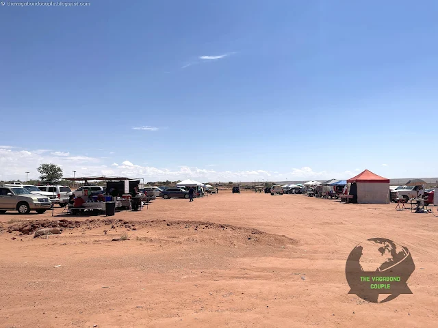
Behind the main commercial area, we found the open-air market marked on our map.
 |
 |
| Tuba City open-air market Stalls across the dusty lot and cooks at the fry bread and mutton stand. | |
Cooks prepared fry bread and roast mutton over open heat. We sat with local people and ate fresh bread, mutton, corn, peppers and onions. A Navajo weaver laughed and called it “the real Arizona,” then spoke about Changing Woman and Coyote. That conversation belongs to the meal because it happened there, not because every roadside lunch requires a mythology appendix.
Fry bread carries a difficult history. During the Long Walk and confinement at Bosque Redondo, Diné people were removed from their homeland and forced onto government rations. Fried bread became associated with that era and later with gatherings, markets and community identity. Calling it only tragedy or comfort food misses half the plate.
 |
 |
 |
| Lunch in Tuba City Fry bread on the griddle, roast mutton on the plate and the market stall around us. | ||
Roast mutton comes from a different strand of Diné history. Sheep pastoralism developed among Navajo communities during the seventeenth and eighteenth centuries and became central to food, weaving, trade and household life. At our table, the history arrived as smoke, crisp edges and a meal that did not need a garnish of travel-blog adjectives.
Next Stop: Monument Valley to Durango
 |
| Page — Shehzadi reached 11,939 miles while the stop-start system requested a day off. |
Back in Page, Shehzadi’s odometer read 11,939 miles, or 5,544 miles since Maryland. The dashboard also displayed “Stop & Start Unavailable.” The truck had declined one minor duty after carrying us across half a continent. Labor negotiations had begun.
These three days joined a federal dam, a Navajo-run canyon tour, community murals, a young volcano, military history, an old trading post and an open-air meal. The road connected them without pretending they were one story. Shehzadi carried us from one set of consequences to the next.
From Page, Part 16 turns northeast through Monument Valley, Mexican Hat, Valley of the Gods, Goosenecks State Park and Bluff before continuing to Durango, Colorado. The next leg trades slot-canyon walls for long horizons and puts Shehzadi back on red dirt, a substance that had been waiting patiently to rejoin the truck.
Reference route map of The Vagabond Couple’s 9,000-mile USA & Mexico overland roundtrip: Map-1 and Map-2.
- The Vagabond Couple and Shehzadi
