Trans-America USA + Mexico Overland 9,000-mile 31-day Roadtrip | Part 12 | From Death Valley into Yosemite | Eastern Sierra & Tioga Pass
 |
| Glacier Point, Yosemite National Park: Half Dome, Yosemite Valley & Yosemite Falls |
Hello again, fellow wanderers! It’s us, the Vagabond Couple, back with another chapter of our epic 9,000-mile road trip across the USA and Mexico. In our last episode, we left you in the surreal, otherworldly landscapes of Death Valley, where the heat, the salt flats and the sheer vastness of the desert left us in awe (see Death Valley: Sizzling Alien STAR WARS Landscape Below Sea Level | Space Port of Mos Eisley on planet of Tatooine). But today, we’re trading the scorching desert for the towering peaks and alpine lakes of the Sierra Nevada Mountains into Yosemite National Park via Tioga Pass! Buckle up, because this leg of the journey is all about jaw-dropping scenery, winding mountain roads and the kind of natural beauty that makes you want to pull over every five minutes to take a photo.
Leaving Death Valley: CA-190 Westbound
We started our day early, leaving Furnace Creek in Death Valley, climbing out from below sea-level heading west on CA-190. As we drove, the landscape began to change almost immediately. The stark, barren beauty of the desert gave way to rolling hills, rugged mountains and the occasional patch of greenery. It’s amazing how quickly the scenery shifts in this part of the world - one minute you’re in the driest place in North America and the next, you’re surrounded by the lush, green foothills of the Eastern Sierra Nevada.
 |
| California CA-190 Death Valley (Panamint Valley) |
One of the highlights of CA-190 is the Panamint Valley, a vast, open expanse that feels like a smaller, quieter version of Death Valley. The valley is surrounded by towering mountains and the road winds through it like a ribbon, offering stunning views at every turn. We stopped at the Father Crowley Vista Point for great views of Panamint Dunes and the rugged peaks of the Panamint Range. It’s a place that feels both wild and peaceful and it’s a reminder of the incredible diversity of California’s landscapes.
Lone Pine and the Alabama Hills: A Hollywood Backdrop
As we continued west, we reached the town of Lone Pine, a charming little spot at the base of the Eastern Sierra Nevada. Lone Pine is famous for its proximity to the Alabama Hills, a collection of massive, rounded boulders and rock formations that have been the backdrop for countless Hollywood movies, from Gunga Din to Iron Man.
.jpg) |
| Alabama Hills |
We couldn’t resist taking a short detour to explore the Alabama Hills. The rocks here are otherworldly, with their smooth, weathered surfaces and dramatic shapes. It’s easy to see why filmmakers love this place - it feels like a natural movie set. We also learned that the Alabama Hills are named after a Confederate warship, the CSS Alabama, which was used during the Civil War. It’s a reminder of how history and culture are woven into the landscape in ways you might not expect.
CA-395: The Eastern Sierra Scenic Byway
From Lone Pine, we turned north onto CA-395, also known as the Eastern Sierra Scenic Byway. This road is one of the most beautiful drives in the country, with its towering mountains, alpine lakes and endless vistas. As we drove, we couldn’t help but feel a sense of excitement - this was the gateway to the Sierra Nevada, one of the most iconic mountain ranges in the world.
One of the first highlights of CA-395 is the Seven Pines area, where the road winds through a dense forest of pine trees, with the jagged peaks of the North Palisade rising in the distance. The North Palisade is one of the tallest peaks in the Sierra Nevada and its sheer, granite face is a sight to behold. We pulled over at a viewpoint to take it all in, marveling at the way the sunlight played off the rocks and the trees.
Tioga Pass: The Stunning Gateway to Yosemite
As we continued north, we reached Tioga Pass, the highest highway pass in California and one of the most stunning drives in North America. At an elevation of 9,943 feet, Tioga Pass is not just a road - it’s an experience. The pass cuts through the heart of the Sierra Nevada, offering breathtaking views of alpine lakes, granite peaks and meadows filled with wildflowers.
 |
| TIOGA PASS |
One of the highlights of Tioga Pass is Ellery Lake, a crystal-clear alpine lake that reflects the surrounding mountains like a mirror. We also passed Tioga Lake and Dana Meadows, two more spots that left us in awe of the natural beauty of this area. The road itself is a marvel of engineering, winding through the mountains with steep drop-offs and tight curves that keep you on your toes.
Tioga Pass is also the eastern entrance to Yosemite National Park and as we approached the park gate, we couldn’t help but feel a sense of anticipation. Yosemite is one of the most iconic national parks in the world and we were about to get our first glimpse of its legendary beauty.
A Temporary Pass Through Yosemite
Now, here’s where things got interesting. Our timed-entry pass for Yosemite wasn’t valid until the next day and our lodging for the night was in Oakhurst, CA, on the western side of the park. But the kind park rangers at the Tioga Pass gate gave us a three-hour temporary pass - just enough time to drive through Yosemite without stopping!
 |
| TIOGA PASS gate - Yosemite National Park, California, USA |
As we drove through the park, we got our first views of Yosemite’s iconic landmarks - Half Dome, El Capitan and the Tuolumne Meadows. The scenery was so stunning that it was almost painful not to stop and take photos, but we knew we’d be back the next day to explore in full.
Oakhurst, California: A Quiet Night in the Foothills
We arrived in Oakhurst just as the sun was setting, with the Sierra Nevada glowing in the distance. Oakhurst is a charming little town at the southern-western edge of Yosemite and it’s the perfect base for exploring the park.
 |
| Vons in Oakhurst: a large, convenient and well-stocked grocery store |
We checked into our hotel, had a quick dinner and spent the evening planning our adventures for the next day.
Return to Yosemite National Park
After a quiet night in Oakhurst, we woke up early, fueled up on coffee and hit the road back into Yosemite National Park. Today was all about exploring the park in full, from the towering granite cliffs to the ancient giant sequoias. So grab your hiking boots (or just your imagination) and let’s dive into the wonders of Yosemite.
Re-entering Yosemite: The South Gate
We re-entered Yosemite through the South Gate, driving along Wawona Road as the sun began to rise over the Sierra Nevada. The road winds through dense forests and open meadows, with the occasional glimpse of the park’s iconic granite peaks in the distance. It’s a peaceful, almost magical drive and it set the tone for the day ahead.
Our first stop was Mariposa Grove, home to some of the largest and oldest living things on Earth: the Giant Sequoias. These towering trees are a must-see for anyone visiting Yosemite and we couldn’t wait to stand among them.
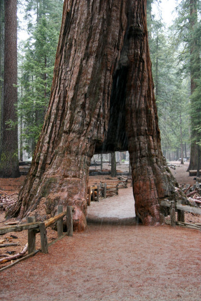
Mariposa Grove: Walking Among Giants
 |
| Mariposa Grove of Giant Sequoia |
Mariposa Grove is the largest sequoia grove in Yosemite and it’s home to over 500 mature giant sequoias. To protect the trees and their delicate root systems, the park service runs a shuttle bus from the parking area to the grove. We hopped on the shuttle and were soon surrounded by these ancient giants.
The giant sequoias are truly awe-inspiring. Some of the trees in Mariposa Grove are over 2,000 years old and they can reach heights of 250 feet or more. Walking among them feels like stepping back in time and it’s impossible not to feel a sense of reverence for these living monuments.
 |
| Mariposa Grove of Giant Sequoia |
Here are a few of the most famous trees in the grove.
The Grizzly Giant
This is one of the largest trees in Mariposa Grove, with a base diameter of over 30 feet. It’s estimated to be around 1,800 years old and its massive, twisted branches are a sight to behold.
The California Tunnel Tree
 |
| The California Tunnel Tree Photo Credit: Yosemite Hikes |
This tree has a tunnel carved through its base, allowing visitors to walk through it. It’s a reminder of a time when such practices were common, but today, the park service works hard to protect the trees from damage.
The Faithful Couple
This unique tree is actually two trees that have grown together at the base, creating a single, massive trunk. It’s a symbol of unity and resilience and it’s one of the most photographed trees in the grove.
As we walked through the grove, we couldn’t help but think about the Native American tribes who have lived in this area for thousands of years. The Ahwahneechee people, who are the original inhabitants of Yosemite, consider the giant sequoias sacred and they have many legends and stories about these ancient trees. One legend tells of a great flood that covered the Earth and how the giant sequoias were the only things tall enough to rise above the water.
Driving Through Yosemite: Wawona Road to Tioga Road
After exploring Mariposa Grove, we hopped back into Shehzadi and continued our drive through Yosemite. Our plan was to retrace our route from the day before, driving from the South Gate all the way back to Tioga Pass on the eastern side of the park.
The drive took us along Wawona Road, Big Oak Flat Road and finally Tioga Road, each offering its own unique views and experiences. Here are a few of the highlights.
Tunnel View
 |
| Tunnel View, Yosemite National Park: El Capitan, Bridalveil Fall and Half Dome |
This iconic viewpoint offers one of the most famous vistas in Yosemite, with El Capitan, Bridalveil Fall and Half Dome all visible in one stunning panorama. It’s a must-stop for anyone visiting the park and we spent a good amount of time here, soaking in the views and snapping photos.
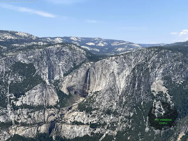
Glacier Point
 |
| Glacier Point, Yosemite National Park |
We took the Glacier Point road offshoot all the way to Glacier Point. The road offers stunning views of Yosemite Valley and the surrounding mountains and it’s a great place to get a sense of the park’s scale and beauty.
Yosemite Valley was shaped by a combination of tectonic forces, glacial activity and erosion over millions of years. The story begins around 10 million years ago, when the Sierra Nevada range began to uplift, tilting westward and creating steep eastern slopes. This uplift exposed the granite bedrock that forms the valley’s towering cliffs and domes, like El Capitan and Half Dome.
 |
| Glacier Point, Yosemite National Park: Yosemite Valley & Yosemite Falls |
Around 2 to 3 million years ago, during the Ice Age, glaciers carved through the valley, grinding and sculpting the granite into its current U-shaped form. These massive glaciers, some over 2,000 feet thick, deepened the valley and polished its walls, leaving behind the dramatic vertical faces and smooth rock surfaces we see today.
As the glaciers retreated, they deposited debris, creating the flat valley floor and allowing the Merced River to flow through, further shaping the landscape. The result is a geological masterpiece - a valley of sheer granite walls, cascading waterfalls and lush meadows that continues to inspire awe and wonder.
 |
| Glacier Point, Yosemite National Park: Yosemite Valley & Yosemite Falls |
The Merced River, one of the most iconic waterways in Yosemite National Park, has its source high in the Sierra Nevada Mountains. It begins as a series of small streams and springs near Merced Peak and Mount Lyell, the highest peak in Yosemite, at an elevation of over 13,000 feet.
These streams converge to form the Merced river, which then flows through Lyell Canyon, a stunning glacial valley surrounded by towering peaks and alpine meadows. As the Merced River winds its way westward, it carves through the heart of Yosemite Valley, passing by iconic landmarks like Half Dome, El Capitan and Yosemite Falls. It provides the lifeblood for the valley’s lush ecosystems and is responsible for the dramatic waterfalls that cascade down the granite cliffs.
 |
| Glacier Point, Yosemite National Park: Half Dome & Yosemite Valley |
The Merced river eventually exits Yosemite and continues its journey through the foothills of the Sierra Nevada, eventually draining into Lake McClure and Lake McSwain, two reservoirs created by dams along its course. From there, it flows into the San Joaquin River, which ultimately empties into the Pacific Ocean near San Francisco Bay.
 |
| Glacier Point, Yosemite National Park: Yosemite Falls |
Stone Mountain House
There is an ancient stone building at Glacier Point that we walked up into. This is the historic Glacier Point Mountain House, a rustic structure that adds a touch of old-world charm to one of the most iconic viewpoints in the park.
 |
| Stone Mountain House, Glacier Point, Yosemite National Park |
Built in the early 20th century, this sturdy stone building was originally a rest stop for visitors making the trek to Glacier Point, offering refreshments and a place to rest while taking in the jaw-dropping views of Yosemite Valley, Half Dome and Yosemite Falls. Today, it stands as a reminder of the park’s early days of tourism, when adventurers traveled by horseback or stagecoach to witness the park’s grandeur.
 |
| Stone Mountain House, Glacier Point, Yosemite National Park |
The building’s rugged stone construction blends seamlessly with the natural surroundings and its location at the edge of the cliff makes it a perfect spot to pause and soak in the panoramic vistas. Standing there, or sitting on the aisles of the ancient open windows, with the wind in your hair and the vastness of Yosemite stretching out before you ... it’s easy to imagine the awe that early visitors must have felt - and to feel that same awe yourself!
Olmsted Point
 |
| Olmsted Point, Yosemite National Park: View of Half Dome |
Located along Tioga Road, the Olmsted Point viewpoint offers a unique perspective on Half Dome and the surrounding landscape. The granite here is smooth and polished, a result of the glaciers that once covered this area.
Tenaya Lake
 |
| Tenaya Lake, Yosemite National Park Farwestern Photo by Gregg M. Erickson, CC BY 3.0, via Wikimedia Commons |
This crystal-clear alpine lake is one of the most beautiful spots in Yosemite. The water is a stunning shade of blue and the surrounding mountains reflect perfectly in its surface. We stopped here for a quick picnic, enjoying the peace and quiet of this remote corner of the park.
Back at Tioga Pass: The Eastern Gateway
As we approached Tioga Pass, we couldn’t help but feel a sense of accomplishment. This was the same road we had driven the day before, but today we were able to stop and take in the views at our leisure. The pass is a marvel of engineering, cutting through the heart of the Sierra Nevada and offering some of the most stunning views in the park.
We stopped at Ellery Lake and Tioga Lake, two of the most beautiful alpine lakes in the area. The water was so clear that we could see the rocks at the bottom and the surrounding mountains provided the perfect backdrop.
Watch Shehzadi's dashcam video as we drive from Tioga Pass all the way back to Oakhurst:
Watch: Driving Tioga Pass to Oakhurst across Yosemite National Park, California, USA
Final Thoughts: Yosemite, A Place of Wonder
As we drove out of Yosemite and back toward Oakhurst, we couldn’t stop talking about everything we had seen. From the giant sequoias of Mariposa Grove to the towering granite cliffs of Yosemite Valley, this park is a place of endless wonder and beauty. Yosemite is more than just a national park - it’s a testament to the power and beauty of the natural world. It’s a place that inspires awe, humility and a deep sense of connection to the Earth. And for us, it was a reminder of why we love exploring this incredibly beautiful country of the United States of America.
Back in Oakhurst, Shehzadi's odometer was reading 10,704 miles, which means we were now 4,309 miles from home in Hyattsville, Maryland. We are almost halfway into our trans-USA round-trip!
 |
| Oakhurst, CA: Shehzadi Odometer 10,704 miles = 4,309 miles from home in Hyattsville, MD |
We start from Oakhurst tomorrow for the long drive to South Rim of Grand Canyon, crossing Fresno and Bakersfield onto Interstate 40 into Arizona. We will stop at fabulous roadside Punjabi dhabas frequented by Indian as well as western truck drivers on the important I-40 truck route and sample some of the most authentic Dhaba food we have had outside of India! Look out for that story in our next Episode 13: Yosemite to Grand Canyon via Fresno: Mojave Desert, Route 66 and Punjabi Dhabas from California into Arizona!
Reference route map of The Vagabond Couple's 9,000-mile USA & Mexico overland roundtrip: Map-1 and Map-2.
- The Vagabond Couple and Shehzadi
0 comments