Trans-America USA + Mexico Overland 9,000-mile 31-day Roadtrip | Part 11 | Death Valley: Sizzling Alien STAR WARS Landscape Below Sea Level | Space Port of Mos Eisley on planet of Tatooine
 |
| Zabriskie Point, Death Valley |
As we pulled into The Ranch at Death Valley well past midnight, Shehzadi’s (our Toyota Tundra) engine hummed a tired but victorious tune. The road from Nevada's Extraterrestrial Highway through the great Mojave had been an odyssey of imaginary strange lights in the sky, neon-lit alien motels and lonely desert art installations that felt like transmissions from another world (see Aliens and Desert Art to Abyss | E.T. Highway, Aliens and Weird Nevada Desert Art to Death Valley, California). But nothing - absolutely nothing - could have prepared us for the surreal, almost supernatural, experience of the Tatooine landscape of Death Valley in sunlight next morning (Star Wars was filmed here).
The Inferno of Death Valley
Death Valley is the hottest, driest and lowest national park in North America. The ground here has recorded temperatures as high as 134°F (56.7°C), making it the hottest place on Earth. In July, when we arrived, the air itself shimmered with heatwaves even at midnight and Shehzadi’s temperature gauge was running high at 118°F. At 282 feet below sea level, Badwater Basin inside Death Valley is the lowest point in North America, a stark contrast to the 14,107-foot (4,299.83 m) Pikes Peak, Colorado, which we had summitted just 9 days ago. And Shehzadi's thermometer would report 130°F ambient temperature here later!
 |
| Death Valley National Park |
This valley is ancient, sculpted by tectonic shifts, evaporated seas and eons of wind erosion. Native tribes like the Timbisha Shoshone people thrived here for over a thousand years before European explorers stumbled into this otherworldly terrain, giving it the ominous name “Death Valley” during the 1849 California Gold Rush.
The Timbisha Shoshone refer to Death Valley as "Tüpippüh" meaning "rock paint," a reference to the natural pigments found in the area. According to their traditions, the valley is a sacred place, shaped by the actions of ancient spirits. One legend tells of a great flood that once filled the valley, creating a vast lake and another speaks of a powerful spirit who shaped the land with fire and wind.
The Timbisha Shoshone have long adapted to the extreme conditions, using their deep knowledge of the land to survive and thrive in this unforgiving environment.
Zabriskie Point: A Psychedelic Dreamscape
 |
| Zabriskie Point, Death Valley |
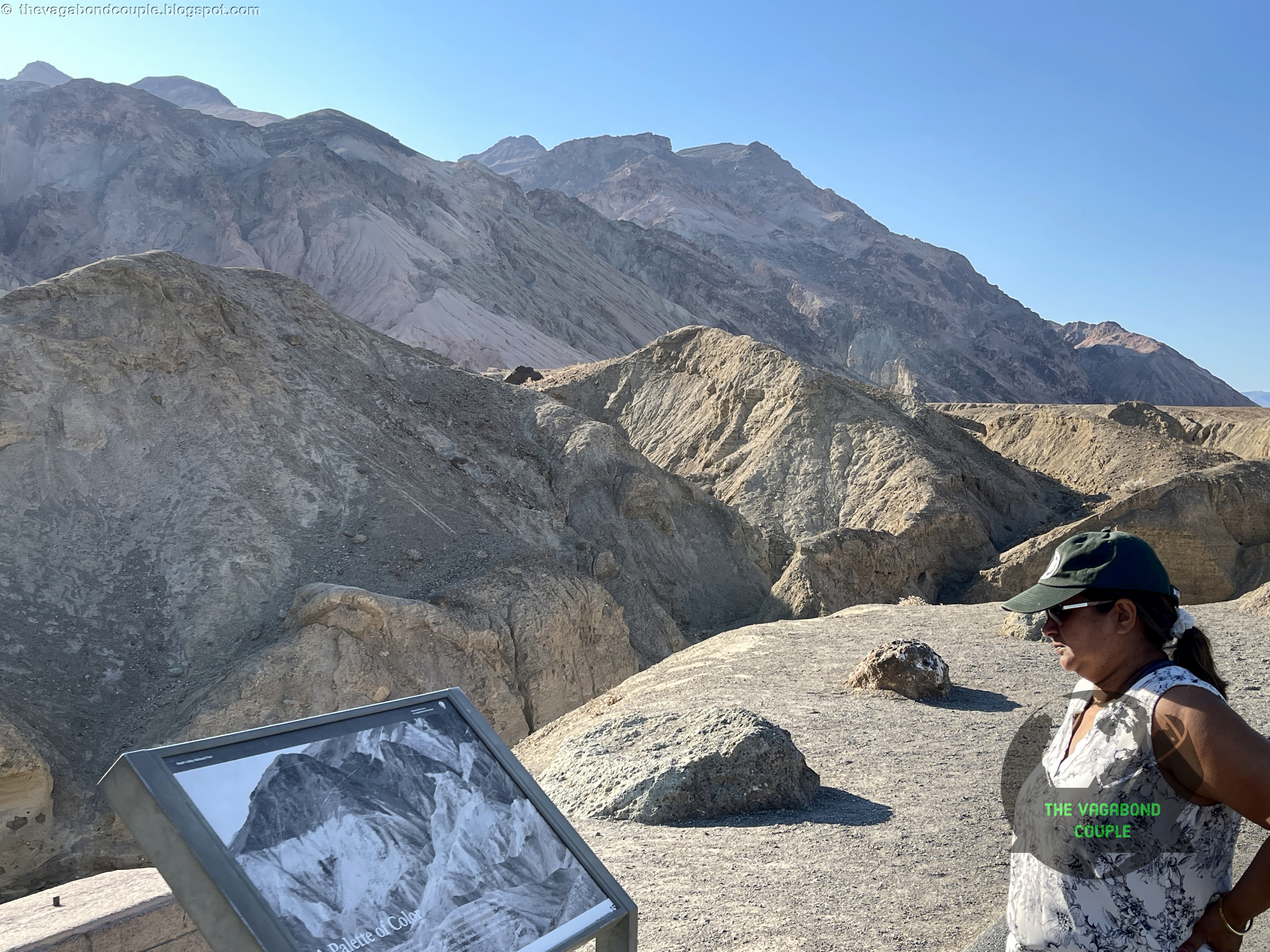
Our first stop the next morning was Zabriskie Point, a place that feels like the landscape of another planet. Rolling badlands of ochre, rust and gold stretch into the distance, carved by time into jagged ridges and sinuous folds. The scene has an almost liquid quality, frozen waves of sediment shaped by millennia of erosion.
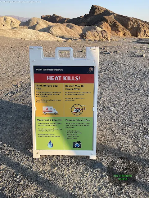 |
| Extreme Heat Warning at Zabriskie Point, Death Valley |
Despite the heat, the landscape at Zabriskie Point is breathtaking. The multicolored badlands, eroded hills and vast desert vistas are especially striking under the bright, high-contrast sunlight. Early morning or late evening visits are ideal for softer light and cooler temperatures.
 |
| Zabriskie Point, Death Valley |
Zabriskie Point is named after Christian Brevoort Zabriskie, a vice president and general manager of the Pacific Coast Borax Company in the early 20th century.
 |
| Zabriskie Point, Death Valley |
The Pacific Coast Borax Company played a significant role in the region's mining history and the name honors Zabriskie's contributions to the area's development.
 |
| Zabriskie Point, Death Valley (Panorama) |
For those attuned to cultural history, Zabriskie Point is more than just a geological wonder - it’s a legendary symbol of the counterculture era. The 1970 film Zabriskie Point, a cinematic rebellion against American capitalism, captured the spirit of the place. You can watch the full movie here, it does have some stunning shots filmed at this location as well as some wonderful shots of driving along CA-190 inside the Death Valley.
 |
| Zabriskie Point, Death Valley |
Pink Floyd’s hypnotic soundtrack for Zabriskie Point (released Feb 9, 1970) cemented it in the annals of psychedelic lore. Standing at the viewpoint as the rising sun painted the hills in fiery hues, we half-expected to hear echoes of Careful with That Axe, Eugene whispering through the canyons. The song was re-recorded for the film and retitled as "Come In Number 51, Your Time Is Up", but you have to wait till the end of the movie to listen to it.
 |
| Still from the motion picture "Zabriskie Point" (1970) |
Badwater Basin: A Blinding White Void at Negative Elevation
 |
| Badwater Basin |
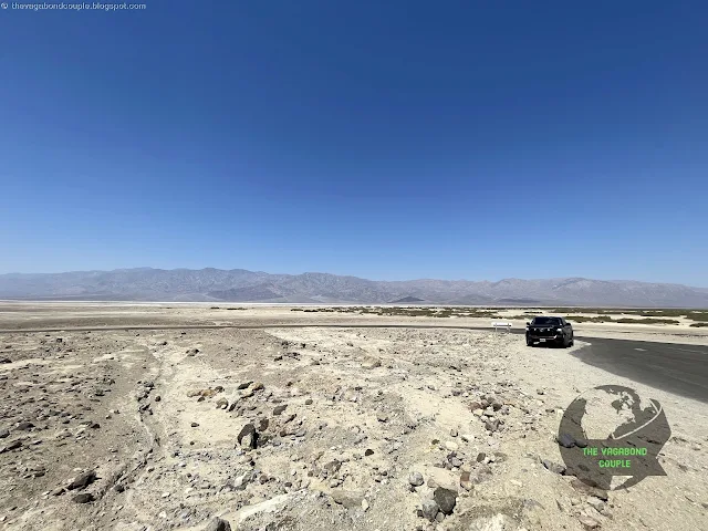
By midmorning, we braved the heat to venture down Badwater Basin Road to reach one of the most extreme places on Earth. Badwater Basin is one of the hottest and driest places on Earth, with summer temperatures often exceeding 120°F (49°C). Its extreme conditions make it a fascinating study in resilience and adaptation for both scientists and visitors.
 |
| Badwater Basin |
At 282 feet (86 meters) below sea level, Badwater Basin holds the title of the lowest elevation in North America, making it a geographic landmark of extreme significance.
 |
| Badwater Basin |
The basin is home to expansive salt flats, created by the evaporation of ancient Lake Manly, which once filled the valley. The hexagonal salt formations and cracked, polygonal patterns on the ground are otherworldly and visually stunning.
 |
| Badwater Basin |
The salt flats of Badwater Basin stretched endlessly before us, a cracked white void bordered by steep, shadowed mountains.
 |
| Badwater Basin |
Similar to the mother of all salt flats Salar de Uyuni, Badwater Basin exists because water that once flooded the valley floor evaporated over time, leaving behind a thick crust of salt.
 |
| Badwater Pool |
The small, murky Badwater Pool - the only water here - got its name when a prospector’s mule refused to drink from it.
 |
| Badwater Pool |
Though seemingly lifeless, the pool actually harbors the incredible Badwater Basin snail (Assiminea infima) - a tiny, endemic species of snail that thrives in the extreme environment of Badwater Basin in Death Valley. This remarkable creature is specially adapted to survive in the harsh conditions of one of the hottest and driest places on Earth. The Badwater Basin snail is found only in the salt flats and spring-fed pools of Badwater Basin, making it a unique part of the ecosystem in this extreme environment. The snail is also incredibly small, measuring only about 2 millimeters in length, making it difficult to spot without close inspection.
 |
| "Sea Level" marker at Badwater Basin in Death Valley |
On the cliffs directly to the west of Badwater Basin, a small sign marks the elevation (zero) of sea level, providing a striking visual contrast between the basin's depths and the towering Panamint Mountains in the distance.
 |
| "Sea Level" marker at Badwater Basin in Death Valley |
This sea level marker serves as a reminder of the dramatic elevation changes in Death Valley, where the basin's salt flats lie far below the surrounding peaks, some of which rise over 11,000 feet (3,350 meters) above sea level. The marker is a popular photo spot for visitors, offering a unique perspective on the region's extreme topography and the forces of nature that shaped it.
The contrast between the bright white salt flats, the surrounding rugged mountains and the deep blue skies creates a surreal and photogenic landscape. The basin's vast, open expanse evokes a sense of isolation and timelessness. The basin's unique geology and hydrology offer insights into Earth's processes, including evaporation, mineral deposition and tectonic activity. It also serves as an analog for studying similar environments on exoplanets.
Devil’s Golf Course: A Place Only the Devil Could Play
 |
| Devil's Golf Course (panorama) |
A few miles from Badwater, we turned onto a rough dirt road leading to Devil’s Golf Course, a surreal expanse of jagged salt formations so sharp and uneven that legend has it “only the devil could play golf here.” The spiky crystals, formed by the slow evaporation of mineral-rich water, have been sculpted by wind and rain into eerie spires and ridges.
 |
| Devil's Golf Course |
Devil's Golf Course is part of the larger Badwater Basin area, but stands out due to its unique and rugged terrain contrasting with the flatter, more uniform salt flats of Badwater Basin.
 |
| Devil's Golf Course |
Walking among the salt crystals here is treacherous - the salt formations are razor-sharp and a fall here could mean serious injury.
 |
| Devil's Golf Course, Death Valley |
We listened to the eerie, faint pops and cracks of the salt expanding and contracting in the heat, a sound that felt like the valley itself was breathing!
Artists Palette & Artists Drive: A Canvas of Earth’s Alchemy
 |
| Artists Palette |
The drive on Artists Drive in Death Valley is a breathtaking 9-mile (14 km) one-way loop that starts and ends on Badwater Road. It winds through colorful, eroded hills and canyons, offering stunning views of vibrant mineral-rich rock formations.
 |
| Artists Palette |
Starting from Badwater Road, the scenic route ascends into the Black Mountains, showcasing a palette of hues - ranging from deep reds and purples to greens and yellows - created by oxidized volcanic deposits.
 |
| Artists Palette |
The highlight is Artists Palette, a section where the colors are most intense, especially in the late afternoon light. Iron, manganese and mica have painted the slopes in shades so vivid they look like the work of some divine brushstroke.
 |
| Artists Palette |
Also from the stunning vantage point of Artists Palette, you can witness a breathtaking array of mountains and geological features that paint a vivid picture of the park's diverse landscape.
 |
| Artists Palette (panorama) |
To the west, the rugged Panamint Range rises dramatically, with Telescope Peak standing as its highest point at over 11,000 feet. To the east, the Black Mountains dominate the view, their dark, weathered slopes contrasting sharply with the vibrant hues of Artists Palette itself. The Badwater Basin, the lowest point in North America, lies to the southeast, while the Funeral Mountains frame the northern horizon. The colorful, eroded hills of Artists Palette are part of the Amargosa Range, showcasing a mesmerizing blend of greens, purples and golds created by the volcanic deposits and mineral-rich sediments. This panoramic vista is a testament to Death Valley's geological wonder
 |
| Artists Drive |
The single-lane, narrow and winding Artists Drive adds to the adventure, with occasional pullouts for photos and contemplation. The loop eventually descends back to Badwater Road, leaving visitors in awe of Death Valley's surreal beauty and geological artistry. Watch our complete dashcam video footage as we drive across the Artists Drive:
Watch: Driving the Death Valley: Artists Palette to Badwater Road Death Valley National Park California USA
The Inn at Death Valley: Mining Tunnel & Life in the Desert
 |
| Porch outside dining hall at the Ranch at Death Valley |
After a long day of heat and mirages, returning to the Ranch at Death Valley and the historic Inn at Death Valley down the street, at Furnace Creek felt like stepping into an illusion. Lush date palms swayed against a backdrop of barren mountains, their green fronds an impossible contrast to the desolation surrounding them.
The Inn at Death Valley features a historic and iconic Tunnel that is a relic of the region's mining past, offering a glimpse into the ingenuity and determination of early 20th-century prospectors. Carved into the rugged hillsides near Furnace Creek, this tunnel was part of the extensive mining operations that sought to extract Borax and precious minerals from the surrounding mountains.
 |
| Historic Mining Tunnel at the Inn at Death Valley |
Walking through the tunnel, visitors can almost hear the echoes of pickaxes and feel the grit of the miners who toiled in the harsh desert environment. The cool, dark interior contrasts sharply with the sun-scorched landscape outside, creating a surreal experience.
 |
| Badwater Basin view from roof terrace of the Inn at Death Valley |
This greenery exists thanks to underground water sources that have been carefully managed for centuries. The Furnace Creek area, despite its name, was once sustained by a system of ancient water tunnels used by both Native Americans and later miners searching for borax deposits.
 |
| Badwater Basin Salt Flat view from roof terrace of the Inn at Death Valley |
We spent our evening on the terrace of the historic Inn at Death Valley, watching the sky explode in reds, purples and deep oranges as the sun dipped below the horizon. The silence was profound and for a moment, we felt like we had left Earth entirely.
 |
| View from roof terrace of the Inn at Death Valley |
The Lowest Golf Course in the World
We begin the next morning with an unbelievable buffet breakfast served in the middle of the uninhabitable terrain by the Ranch at Death Valley. Full and energized for the day, we head out to the Furnace Creek Golf Course, the lowest golf course in the world at 214 feet below sea level!
 |
| Furnace Creek Golf Course, Death Valley |
Playing golf in this heat seemed like an extreme sport, but surprisingly, it remains a popular destination for adventurous golfers looking to play a round in the most unlikely setting.
Golden Canyon: the Tatooine of Luke Skywalker
 |
| Golden Canyon Trail, Death Valley |
We leave the green of the capsule habitat of Furnace Creek and reach the trailhead of the Golden Canyon on Badwater Road.
 |
| Golden Canyon Trail, Death Valley visitor information board |
The Golden Canyon is one of Death Valley's most iconic and visually stunning hikes and a filming location for Star Wars, specifically the revolutionary Star Wars: Episode IV - A New Hope (1977). This is the place used as the backdrop for the iconic Tatooine landscape, the desert home planet of Luke Skywalker. The Golden Canyon's golden, rugged terrain and otherworldly beauty perfectly captured the look of a remote, alien world.
 |
| R2-D2 in Golden Canyon, Death Valley / Tatooine |
One of the most memorable scenes filmed here is when R2-D2 is captured by the Jawas and taken away in their Sandcrawler, with the dramatic canyon walls providing a striking visual setting. This location, along with other spots in Death Valley like Desert Pass and Twenty Mule Team Canyon, helped bring the fictional universe of Star Wars to life, making it a pilgrimage site for fans of the franchise.
 |
| Golden Canyon Trail, Death Valley Extreme Heat Danger Sign |
The Golden Canyon surrounds you with towering cliffs, narrow passageways and vibrant rock formations that seem to glow in the sunlight.
 |
| Golden Canyon Trailhead, Death Valley |
There is a more challenging loop that connects to the Red Cathedral and Gower Gulch. However, it is already past the safe period of early morning in July and there is genuine danger in hiking on a trail at this hour in Death Valley heat. The posted STOP sign talks is a Danger sign, not a Warning!
 |
| Golden Canyon Trailhead, Death Valley |
We play it safe today and turn back into the comfortable bowels of Shehzadi.
The Lowest Gas Station in the West: Furnace Creek Fuel & Auto Service
The Furnace Creek Gas Station, located in the heart of Death Valley National Park, is more than just a place to fill up your tank - it's a lifeline for travelers exploring one of the most remote and extreme environments on Earth. Situated near the Furnace Creek Visitor Center, this gas station is famously known as the lowest-elevation gas station in the Western Hemisphere, sitting at 190 feet below sea level.
 |
| Furnace Creek Gas Station (prices at morning of July 11, 2024) |
The Furnace Creek Gas Station offers not only fuel but also basic supplies, snacks and a chance to cool off with some ice-cold drinks. Its convenience and location make it a vital hub for visitors navigating the vast and awe-inspiring landscapes of Death Valley. It is also understandably a bit expensive, but be thankful there is a working gas pump in the middle of the Tatooine landscape!
Bikers from Ukraine!
At the Furnace Creek gas station, we met a group of motorcyclists sporting HOG (Harley Owners Group) Chapter of Ukraine patches!
 |
| Bikers from Ukraine at Furnace Creek Gas Station in Death Valley |
It is always awesome to meet fellow Harley-Davidson enthusiasts who share a passion for the open road and the iconic American motorcycle brand, especially riders from overseas from a country facing challenges.
130°F on CA-190 - So long, Death Valley
 |
| CA-190 Death Valley |
As we were driving out of Death Valley National Park on California State Route 190, Shehzadi's outside temperature sensor started reporting an unbelievable 130°F (54.4°C). Fearing we were in an environment outside Shehzadi's design parameters, we did not stop for a while. We were relieved when the indicator went down by 1°F instead of going further up and stopped to take an iconic picture of Shehzadi's display screen at the unforgettable Death Valley, California, USA.
 |
| Shehzadi in 129°F Death Valley temperature, 10,256 odometer (3,861 miles from home) |
CA-190, the highway that cuts through the heart of Death Valley National Park, traverses some of the most rugged and awe-inspiring terrain in the United States. Summarizing our journey on this stunning highway, this route takes travelers through a dramatic landscape of vast salt flats, towering mountain ranges and deep, winding canyons.
 |
| CA-190 Death Valley |
As you drive, you'll pass iconic landmarks like the Mesquite Flat Sand Dunes, the Artist's Palette with its vibrant mineral-stained hills and the Zabriskie Point overlook, which offers panoramic views of the park's eroded badlands.
 |
| CA-190 Death Valley |
The road also skirts the edge of Badwater Basin, the lowest point in North America at 282 feet below sea level and climbs up to Dante's View, where you can gaze over the valley from over 5,000 feet above.
 |
| CA-190 Death Valley |
The stark beauty of the desert, with its extreme temperatures and sparse vegetation, creates an otherworldly experience that feels both desolate and profoundly majestic.
 |
| CA-190 Death Valley |
The construction of CA-190 was a feat of engineering, completed in the 1930s as part of efforts to make Death Valley more accessible to visitors. The road was built to connect the park's key attractions, allowing travelers to experience its unique geology and history. Its creation opened up the region to tourism, though the harsh environment and remote location made construction a challenging endeavor.
Reflections on an Alien World
In all our travels, few places have felt as unearthly as Death Valley. The only landscape that is comparable is the Andes Altiplano across Chile, Bolivia and Peru, where we had driven past the towering Volcán Ollagüe and the high-altitude lagoons where NASA tests Mars rovers. But even those Andean heights lacked the sheer, overwhelming desolation of Death Valley.
Driving out of the valley, Shehzadi’s tires kicked up dust as we left behind one of the most extreme places on Earth. It was a land of contradiction - deathly yet vibrant, empty yet full of stories, an inferno where life, against all odds, refuses to surrender.
Exiting the Death Valley, we were now 3,861 miles from home. Continuing our epic road trip, we next drive across the rugged, untamed beauty of the Eastern Sierra Nevada mountains, crossing the Palisades and then over the legendary Tioga Pass to Yosemite National Park and beyond. Our journey continues at From Death Valley into Yosemite | Eastern Sierra & Tioga Pass!
Reference route map of The Vagabond Couple's 9,000-mile USA & Mexico overland roundtrip: Map-1 and Map-2.
- Vagabond Couple & Shehzadi
0 comments