
 |
| Paddlewheel Steamboat "Natchez" sailing on Mississippi River in New Orleans |
We reached New Orleans the previous afternoon (see NOLA Calling - From the Cajun Capital to the Soul of the South: Lafayette to New Orleans via Baton Rouge), parked Shehzadi in a secure paid lot near our BnB, picked up Jazzy Pass fare cards for the city’s public transit, and took a first look at Bourbon Street before calling it a night. Our base was near the corner of St. Charles and Euterpe. This morning the truck could stay put: our last full New Orleans day would run on streetcars, ferry decks and shoe leather.
 |
| Mardi Gras ornaments hung on a tree on Melpomene St, New Orleans |
Mardi Gras beads still hung from neighborhood trees as we stepped outside. They were enough scene-setting on their own; New Orleans did not need a brochure paragraph from us. We were headed first for Canal Street, then across the Mississippi to Algiers Point, back through the French Quarter, and finally into a night of jazz on Bourbon Street.
Trans-America Overland Part 22: New Orleans French Quarter, Algiers Point and Bourbon Street — Post Summary
We spend a full New Orleans day away from Shehzadi, riding the St. Charles streetcar, crossing to Algiers Point, walking the French Quarter, visiting Café du Monde and St. Louis Cathedral, and ending with live jazz and dinner on Bourbon Street.
| What's Covered | |
| 🚋 | St. Charles Streetcar and Canal Street — streetcar ride from Euterpe to Canal Street |
| ⛴️ | Canal Street Ferry to Algiers Point — Mississippi ferry crossing |
| 🎷 | Algiers Point Levee, Courthouse and Jazz Walk — levee walk, courthouse history and Jazz Walk |
| ☕ | French Market, Tujague’s and Café du Monde — Decatur Street, market blocks and café stop |
| ⛪ | Jackson Square and St. Louis Cathedral — cathedral interior and surrounding landmarks |
| 🚢 | Mississippi River at the Moonwalk — riverfront and paddlewheel boats |
| 🎺 | Bourbon Street and Maison Bourbon — Bourbon Street night and live jazz |
| 🎶 | Fritzel’s European Jazz Pub — traditional jazz at Fritzel’s |
| 🍽️ | Dinner at the Cat’s Meow Above Bourbon Street — balcony meal |
| 🛣️ | Next Stop — New Orleans to Hyattsville — handoff to the drive home |
We spent our final full day in New Orleans on a local loop from St. Charles Avenue to Algiers Point and back into the French Quarter before returning to our BnB. We used the streetcar, ferry and our feet while Shehzadi stayed in her parking spot. Highway mileage gave way to river history, beignets, cathedral interiors and live jazz.
Method: Streetcar · walking · Canal Street–Algiers ferry; Shehzadi parked during local sightseeing
Distance / Time: Exact local distance not recorded · full day
Themes: Mississippi River · Algiers Point history · French Quarter · jazz
Vehicle: Shehzadi (2024 Toyota Tundra; parked during this local loop)
Route at a Glance
- Euterpe stop to Canal Street — St. Charles streetcar
- Canal terminal to Algiers Point — Mississippi River ferry
- Algiers riverfront — levee, courthouse, slave-trade marker and Jazz Walk
- Return to Decatur Street — ferry, French Market and café stop
- Jackson Square — cathedral visit and surrounding landmarks
- Moonwalk — Mississippi River and paddlewheel boats
- Bourbon Street — Maison Bourbon live jazz
- Bourbon Street — Fritzel’s European Jazz Pub
- Cat’s Meow to the BnB — balcony dinner and streetcar return
St. Charles Streetcar and Canal Street
We were already carrying Jazzy Passes bought at the Walgreens at Canal & Bourbon the evening before, so the first leg was simple. We boarded near Euterpe and rode the St. Charles line downtown, stepping off around Canal Street. For once, nobody had to negotiate traffic with a Toyota Tundra the size of a small postal district.

|

|

|
| Streetcar to Canal Street Euterpe stop, a Perley Thomas car, and our arrival near Canal and Exchange Place. |
||
RTA describes the St. Charles line as the world’s oldest continuously operating streetcar line. It began service in 1835 as the New Orleans and Carrollton Railroad. Early service used steam and later horse traction before electrification in 1893. Perley A. Thomas cars entered service in 1923–24. The St. Charles Streetcar Line itself is a National Historic Landmark.
The ride itself made the transport history tangible. Green streetcars and the close spacing of the seats felt very different from climbing back into Shehzadi. For this one day, the city’s old transit system carried us from the neighborhood straight into downtown.
Canal Street is roughly 171 feet wide because its original plan reserved a broad center strip for a navigation canal that was never built. We followed the streetcar tracks and old commercial façades toward the Mississippi, walking through the footprint of a canal that remained on paper.
Near Canal Street we stopped at the Vitascope Hall historical marker. It marks an 1896 projected-motion-picture venue that used the Edison-marketed Vitascope. The Lumière Cinématographe was a competing system, so the marker belongs to the Vitascope story rather than to Lumière agents.
 |
| Vitascope Hall Historical Marker on Canal Street, New Orleans |
Commercial façades along the 600 block, streetcar infrastructure at Canal and South Peters, and later blocks carried us toward the Mississippi. At the river end of Canal Street, the ferry terminal became our next fixed point.

|

|

|
| Toward the river Canal Street façades, streetcar tracks, and the ferry terminal at the Mississippi end of the avenue. |
||
Canal Street Ferry to Algiers Point
We boarded the Canal Street ferry for Algiers Point. Regular ferry service between Canal Street and Algiers dates to 1827. On our crossing, the immediate attraction was simpler: leave the East Bank, stand in the open air, and watch the city rearrange itself across a moving river.

|

|

|
| Leaving the East Bank downtown New Orleans and the Crescent City Connection recede as the ferry moves into the Mississippi. |
||
Downtown and the French Quarter’s lower roofline receded while the Crescent City Connection framed part of the view. Tugboats, barges and docks kept the Mississippi visibly busy around our short passenger crossing.
Mid-river, the skyline kept changing with every few seconds of movement. The low French Quarter roofs sat against taller downtown buildings, while the bridge and river traffic shifted position around them. It was a short crossing, but it gave us a viewpoint no street corner could offer.
One tugboat supplied the day’s least subtle greeting by shooting tall columns of water into the air. A tugboat apparently doing its own fountain show in the middle of the Mississippi was already a fairly complete joke.
 |
| Tugboat on Mississippi performing "Water Salute" by shooting columns of water |
As the ferry closed on the West Bank, the perspective reversed. The boat, downtown skyline and river landing filled the last few minutes of the crossing, and Algiers Point came into view at a much quieter scale than the streets we had just left.

|

|
| Closing on Algiers Point the ferry and downtown skyline seen as the West Bank landing approaches. |
|
Algiers Point Levee, Courthouse and Jazz Walk
The welcome sign made the change of bank official. We left the landing on foot, passed a mural by New Orleans artist Lionel Milton on Bouny Street near the Dry Dock Café, and reached the grassy levee. Houses sat behind it, though their individual elevations were not something we could determine simply by looking.
 |
| Algiers Point Welcome Sign at Ferry Terminal |
Algiers Point mixed familiar New Orleans house types with Greek Revival and Italianate influences. From the levee we saw houses, mature trees, older commercial buildings and working-river infrastructure sharing the same compact neighborhood.

|

|

|
| First walk beyond the landing a neighborhood mural, the levee path, and houses along the Algiers riverfront. |
||
The red-brick Algiers Courthouse became our next landmark. Nearby, a transatlantic-slave-trade marker records Algiers Point’s connection to the forced arrival and movement of enslaved people. The marker made that specific history part of our walk.
 |
| Algiers Courthouse |
A much later episode also belongs to Algiers Point. After Hurricane Katrina, white residents erected barricades and armed patrols. Roland Bourgeois Jr. shot three Black men trying to reach the ferry evacuation site; he later pleaded guilty and was sentenced for the hate crime. Contemporary reporting also documented broader vigilante violence in Algiers Point.
 |
| Transatlantic slave trade plaque at Algiers Point courthouse, New Orleans |
We continued along Patterson Road past the former Canal Commercial Trust and Savings Bank building and a run of houses close to the levee. Together they showed the residential side of Algiers Point as we moved farther from the ferry landing.

|

|

|

|

|
|
||
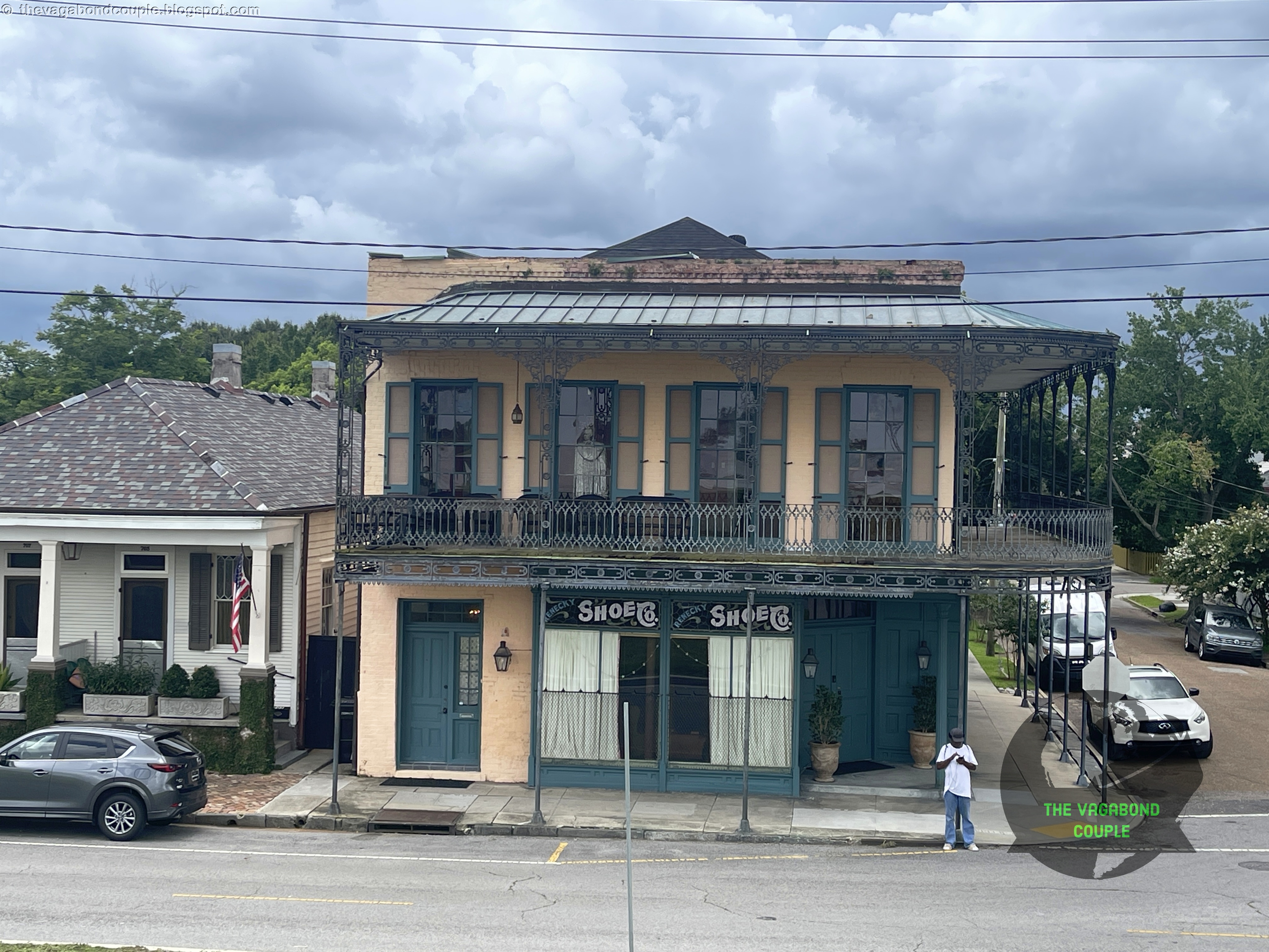
| Along Patterson Road the old bank building, residential blocks, and the weathered building carrying visible SHOE CO. lettering. |
|||
One weathered building carried visible “SHOE CO.” lettering. The sign gave us only those words. A white mannequin stared from an upstairs window, though, and looked as if it had been waiting a very long time for the ferry.
 |
| White mannequin looking from an upstairs window of a weathered Algiers Point building |
Farther along, residential buildings gave way to the working riverfront, including mooring and towing signs. Cooper Mooring and Crescent Towing were visible parts of the scene, and we left the weathered signs to speak for themselves.

|

|

|

|
| Working-river Algiers houses beside the levee give way to mooring and towing signs along the waterfront. |
|||
Near the landing area were the Dry Dock Café, Crown & Anchor English Pub and Rising Sol Bed and Breakfast. “Rising Sol” nudged us toward House of the Rising Sun by name alone. The resemblance ended with the name; we know of no actual connection.
The Jazz Walk of Fame brought the route back to New Orleans music history. Its markers and a Louis Armstrong statue also reminded us that the city’s music story extends well beyond Bourbon Street.
 |
| Jazz Walk of Fame, Algiers Point Levee, New Orleans |
The Louis Armstrong statue closed our Algiers walk before we headed back toward the ferry and the East Bank.
From the Armstrong statue we retraced our steps toward the ferry landing. The return crossing traded the quieter Algiers levee for the denser blocks of the French Quarter in a matter of minutes.
 |
| Louis Armstrong statue on Jazz Walk of Fame, Algiers Point Levee, New Orleans |
French Market, Tujague’s and Café du Monde
Back across the Mississippi, we returned to Decatur Street and the French Market. Spanish authorities built an early market near Chartres and Dumaine around 1782. Around 1790 the market shifted toward present-day Decatur; after later storm damage, the Meat Market was rebuilt in 1813, and the Vegetable Market followed in 1822.
Decatur Street, including the Dumaine Street corner, pulled the city back into close quarters. Market buildings, restaurant fronts, queues and carriage traffic arrived one after another, so the route from the ferry to Café du Monde felt like one continuous street-level walk rather than a checklist of attractions.

|

|

|

|

|

|
||
| Decatur Street on foot market blocks, Tujague’s restaurant, and the Café du Monde storefronts along our walk. |
|||
We passed Tujague’s, established in 1856, but did not eat there. Nearby Antoine’s added another familiar restaurant name, while the Café Du Monde’s Mail Order Spot on Decatur remained simply a storefront we photographed.
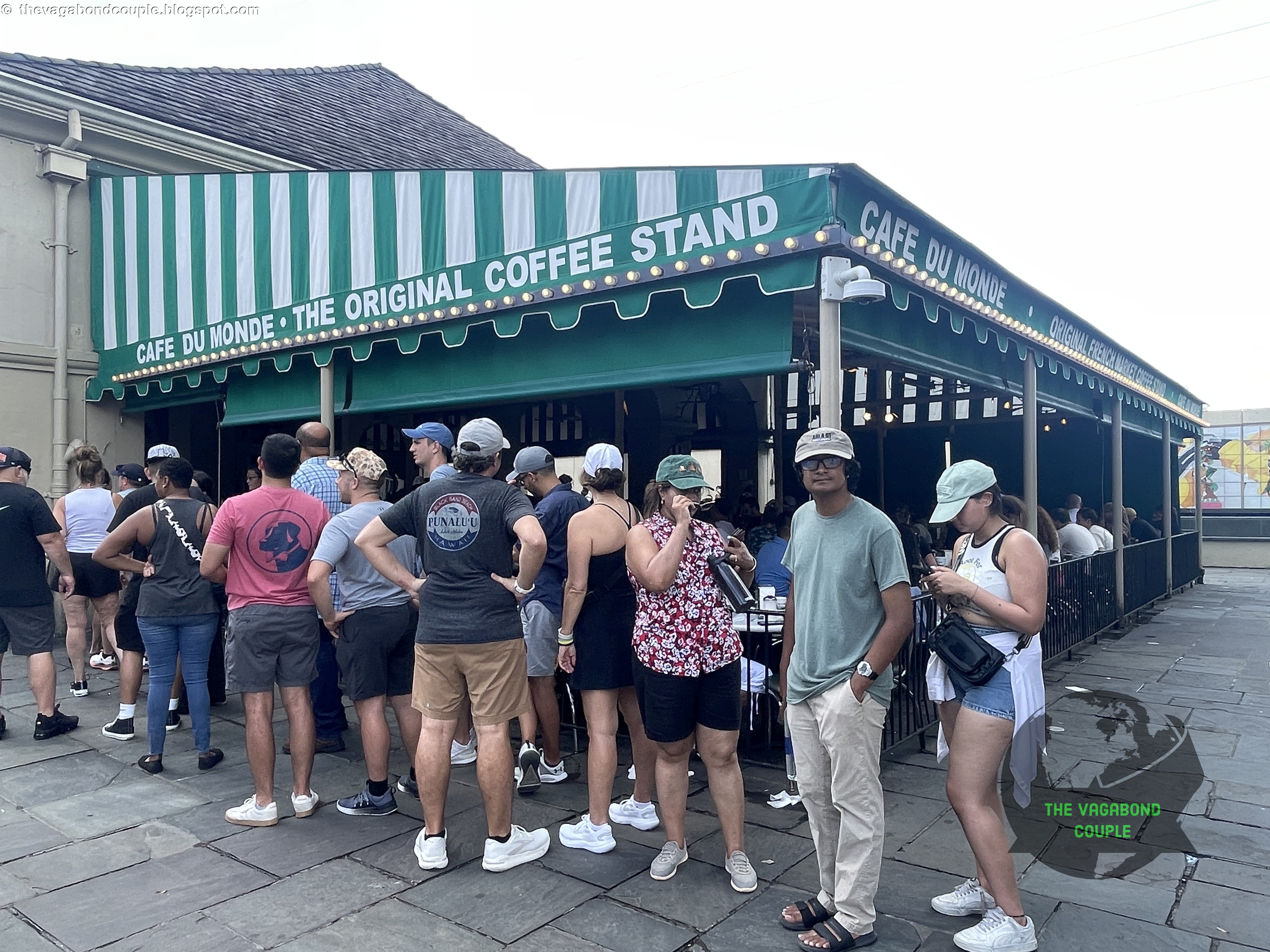
At Café du Monde, the queue was real. We joined it and waited for a table.
 |
| Queue for a table at Café du Monde |
A historical Café du Monde sign advertised round-the-clock service. It records an older service pattern, not current opening hours.
 |
| Café du Monde, New Orleans |
Then came café au lait and beignets. We sat under the covered seating area, dealt with the powdered sugar, and watched staff and tables turn over around us. That was quite enough evidence for the fame of the place.
From Decatur Street, Jackson Square and St. Louis Cathedral were visible in the distance.
|

|

|

|
| Café du Monde stop the queue, café au lait and beignets, the covered seating area, and Decatur Street outside. |
|||
On Decatur Street we photographed a Spanish-period street-name tile reading Camino Real and Muelle. Its wording places it in the Spanish Louisiana naming period without requiring a more precise date from us.
 |
| Spanish Louisiana Street Name Sign: Camino Real = Royal Road, Muelle = Dock, Pier or Wharf |
At St. Ann and Chartres, a long red building with dark iron galleries pulled our minds back to southern Utah. We took the resemblance for what it was: a visual echo of red rock from an earlier leg.
 |
| St Ann St. & Chartres St |
From St. Ann and Chartres we continued toward Jackson Square.
Jackson Square and St. Louis Cathedral
From Washington Artillery Park across Decatur Street, Jackson Square compressed several New Orleans landmarks into one view: the Andrew Jackson equestrian monument, street performers, the cathedral façade and the flow of people between Decatur Street and the square. We watched a street magician work in front of St. Louis Cathedral before going inside.
Jackson Square kept changing depending on which way we faced. Turn toward the cathedral and the three spires dominated the view; turn back toward Decatur Street and the square opened toward Washington Artillery Park and the river. Street performance filled the space between those fixed landmarks.

|

|

|
| Jackson Square St. Louis Cathedral, the Andrew Jackson monument, and a street performer sharing the same compact public space. |
||
The cathedral’s chronology runs through several buildings. The first permanent church, completed in 1727, burned in 1788. A Spanish cathedral was completed in 1794. Major rebuilding began in 1849, the central tower collapsed in January 1850, and the enlarged cathedral blessed in 1851 was largely rebuilt because little of the 1794 structure could be retained.

|

|

|

|

|

|
||
| St. Louis Cathedral exterior and interior views, stained glass, a street magician, and the outlook back across Jackson Square. |
|||
Inside we saw stained glass, the painted ceiling, the long nave and the white-and-gold sanctuary. The interior photographs carry those details without asking us to identify the upper altar painting more precisely than we can.
 |
| St. Louis Cathedral ceiling (composite) |
The rear interior and altar gave us a closer sense of scale. It recalled other grand church interiors we have walked through, including The Palace of Versailles: A Triumph of Elegance and Grandeur, while Jackson Square remained immediately outside the doors.

|

|
| Inside the cathedral the rear interior and a closer view of the white-and-gold sanctuary. |
|
The white-and-gold sanctuary drew our attention back toward the altar, where the long interior lines converged.
 |
| Altar in der Kirche Cathedral-Basilica of Saint Louis King of France (Basilica minor) in New Orleans, Luisiana, USA By Arnoldius - Own work, CC BY-SA 4.0, Link |
Outside, the Cabildo and the Presbytère flank the cathedral. The Cabildo hosted the 1803 Louisiana Purchase transfer ceremonies. The Presbytère, on the other side, is now part of the Louisiana State Museum.
Much of the Vieux Carré’s surviving building stock dates from after the 1794 fire and reflects French, Spanish and later American influences. Across Jackson Square, the JAX Brewery building added another period to the same view.

|

|

|
| Around Jackson Square the Cabildo, the Presbytère, and the JAX Brewery building. |
||
From Jackson Square we moved toward the river and the Moonwalk.
Mississippi River at the Moonwalk
At the Moonwalk we watched river traffic pass. NATCHEZ is a genuine steam-powered sternwheeler, while Creole Queen uses diesel-electric propulsion to turn its paddlewheel. The two boats can share the Mississippi without sharing the same machinery.
We had already watched paddlewheels on the Mississippi earlier in the expedition, including a ride aboard the Tom Sawyer in St. Louis. Seeing NATCHEZ and Creole Queen here linked another city to the same river.

|

|
| Riverfront traffic the Mississippi from the Moonwalk and the Creole Queen underway. |
|
The river had organized much of the day without us planning it that way: across to Algiers, back to Decatur, then alongside it here. The city looked different from each edge of the water, and the change from truck travel to ferries and walking had shrunk our geography to a handful of neighborhoods.
By evening we turned away from the river and back toward Bourbon Street.
Bourbon Street and Maison Bourbon
 |
| CALLE D BORBON - Spanish Luisiana name for Bourbon Street |
A Spanish-era tile marked the older name CALLE D BORBON. Sting, Moon Over Bourbon Street (1985) supplied an obvious soundtrack reference. The song could handle its own lyrics.
New Orleans jazz developed across the city from African and Caribbean traditions, brass bands, blues, European forms and immigrant communities. Bourbon Street later became an important nightclub and performance corridor rather than the singular birthplace of the music.
By the time we reached Bourbon Street, daylight had gone and the sidewalks were crowded. Signs, balconies, club doors and people filled the photographs, while we moved in short stages from one music stop to the next instead of trying to take in the whole street at once.
One street promoter held a sign advertising Huge Ass Cantina at 706 Bourbon Street while the crowd moved around him.

|

|

|

|
| Bourbon Street after dark the nighttime crowd and our stop at Maison Bourbon for traditional jazz. |
|||
At Maison Bourbon we stayed for three sets of traditional jazz and bought drinks between them. The band played, we stayed, and the room kept us there.
Watch: Live: Maison Bourbon (dedicated to the Preservation of Jazz), Bourbon Street, New Orleans
Fritzel’s European Jazz Pub
Fritzel’s was our next jazz stop. The venue dates to 1969, and we went inside for another live set.
The move from Maison Bourbon to Fritzel’s kept us on Bourbon Street but changed the room around the music. More drinks and more sets followed, while our photographs and video recorded the musicians and audience.

|

|

|

|

|
|
| Fritzel’s on Bourbon Street the pub, its close quarters, and the live jazz performance we watched inside. |
||
Watch: Live: Fritzel's European Jazz Pub, Bourbon Street, New Orleans
Dinner at the Cat’s Meow Above Bourbon Street
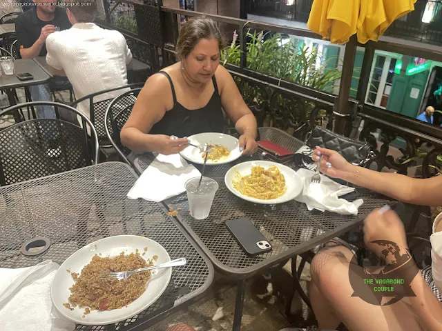
We ended the night upstairs at the Cat’s Meow, with a balcony table above Bourbon Street. Dinner gave us a fixed seat after several hours of streetcars, ferries, sidewalks, jazz clubs and walking.

|
|

|

|
| Dinner above Bourbon Street our balcony table and the crowd moving below the Cat’s Meow. |
|||
At the table we worked through crawfish étouffée, blackened redfish and Bananas Foster bread pudding. After streetcars, ferries, levee walking, beignets, cathedral interiors and jazz sets, we caught the streetcar back toward St. Charles Avenue and our BnB, closing the day’s local loop.
That was the oddity of this New Orleans day. Much of this series had been organized by highways, state lines and fuel stops; here public transit and our shoes handled the city. The Mississippi became the day's organizing line: across it to Algiers, back to the French Quarter, then alongside it at the Moonwalk before Bourbon Street. Near the end of the route, the change of scale worked: one city, several modes of travel, and enough history packed into a few neighborhoods to make mileage temporarily irrelevant.
Next Stop — New Orleans to Hyattsville
The next morning we would retrieve Shehzadi from her parking spot and start the northeast drive home. That final road leg continues in The Last Thousand Miles to Home: New Orleans, Louisiana to Hyattsville, Maryland.
Reference route maps for our Trans-America overland roundtrip: Map-1 and Map-2.
Until next time,
- The Vagabond Couple and Shehzadi
