
 |
| Shehzadi beside the red sandstone formations at Garden of the Gods |
Part 2 ended in Topeka after our Mississippi River cruise, Gateway Arch visit and westbound drive across Missouri. Part 3 begins there, with Shehzadi, our overlanding Toyota Tundra, pointed toward Colorado Springs and the first mountain skyline of the expedition.
I-70 carried us across Kansas, through Salina and into eastern Colorado. Garden of the Gods supplied red sandstone and geological mischief; Pikes Peak supplied thin air, summer snow and a summit reached by shuttle because the cog railway had sold out.
Trans-America Overland Part 3 — Post Summary
Part 3 carries us and Shehzadi west from Topeka across the Flint Hills and High Plains to Colorado Springs. We walk among the tilted sandstone formations of Garden of the Gods, eat Nepali food in the city and reach the Pikes Peak summit by shuttle before the route turns toward Hoosier Pass and Moab.
| What's Covered | |
| 🛣️ | Topeka to Salina on I-70 — Flint Hills, tallgrass country and our lowest fuel price so far |
| ⛰️ | High Plains to Colorado Springs — western Kansas, eastern Colorado and the Front Range approach |
| 🪨 | Garden of the Gods — Balanced Rock, tilted sandstone fins and regional Native history |
| 🥟 | Little Nepal — Nepali chai, momo dumplings, curries and naan in Colorado Springs |
| 🚐 | Pikes Peak by shuttle — summit weather, cog railway, summer snow and Front Range geology |
From Topeka, we drove Shehzadi west on I-70 across Kansas and eastern Colorado to Colorado Springs. The route moved from the Flint Hills through the High Plains before rising against the Front Range, where Garden of the Gods and Pikes Peak turned a long highway day into two very different encounters with rock.
Route: Topeka, Kansas, to Colorado Springs, Colorado
Vehicle: Shehzadi, our Toyota Tundra
Main road: I-70 across Kansas and eastern Colorado
Main experiences: Garden of the Gods, Little Nepal and Pikes Peak
Next leg: Hoosier Pass, Breckenridge, Vail, Glenwood Canyon and Moab
Route at a Glance
- Drive west from Topeka through the Flint Hills to Salina on I-70.
- Cross western Kansas and eastern Colorado toward the Front Range.
- Walk among Balanced Rock and the sandstone fins at Garden of the Gods.
- Stop for Nepali food at Little Nepal in Colorado Springs.
- Reach the Pikes Peak summit by shuttle after the cog railway sells out.
Topeka to Salina on I-70
We left Topeka early and followed I-70 west. Kansas began by refusing its usual assignment as a perfectly flat state. The road crossed the Flint Hills, where rolling ridges preserve one of North America's largest remaining areas of tallgrass prairie, before the ground gradually opened toward central Kansas. Flinty limestone made broad cultivation difficult, helping spare much of the native grass from the plow. The prairie had survived where many flatter soils had not.
Wheat fields, grain elevators and long sightlines took over beyond the hills. Shehzadi settled into the steady highway pace while the horizon performed the useful Midwestern trick of appearing both distant and immediately available.
 |
| The 24/7 Travel Store fuel-price sign in Salina |
In Salina, the 24/7 Travel Store gave us the cheapest fuel of the expedition so far. The signs also advertised a Subway, proving that even a fuel stop can offer both petroleum and sandwich architecture under one roof.
Across the High Plains to Colorado Springs
Western Kansas broadened into the High Plains, and crossing the Colorado state line did not produce an instant wall of mountains. Eastern Colorado remained open and level for many miles. The plains rise gradually toward the mountains, so our elevation was increasing well before the skyline became dramatic. The Front Range became prominent only as we approached Colorado Springs, rising west of the city after a day dominated by sky and road.
 |
| The road toward Colorado Springs beneath dark clouds and the Front Range |
Colorado Springs sits at the eastern foot of the Front Range rather than inside a mountain-ringed valley. Pikes Peak stood west of the city, with Cheyenne Mountain to the south. The mountains formed a western wall instead of a complete ring, a distinction that becomes useful when the truck needs a direction rather than a brochure.
Garden of the Gods and Balanced Rock
Our first Colorado Springs stop was Garden of the Gods, where red sandstone layers rise at steep angles beside the Front Range. Balanced Rock occupies the park's most improbable parking position: a large block resting on a much narrower base, as though geology had placed it there while distracted.
 |
| Balanced Rock above its narrow base at Garden of the Gods |
The nearby information board identifies Balanced Rock as part of the Fountain Formation and estimates its weight at about 700 tons. The rock's present shape comes from a much longer sequence than a single act of erosion.
 |
| The geology information board beside Balanced Rock |
Rivers and debris flows carried sediment from the Ancestral Rockies roughly 320 to 300 million years ago, forming the coarse red beds of the Fountain Formation. Much later, mountain building during the Laramide event tilted those layers toward vertical. Erosion then exposed and separated the fins, towers and balanced forms visible in the park.
 |
| Sleeping Giant and Gray Rock beside the Garden of the Gods trail |
We followed the paths past Sleeping Giant, Gray Rock and other named formations. Some names require imagination; others require imagination and a committee meeting.
 |
| Red sandstone fins and foothills under clouds at Garden of the Gods |
The Nuu-ciu, or Ute, are the original inhabitants of the region and retain deep ties to the area. Other Native nations also have connections to the park and its wider surroundings. The park's playful rock names sit beside a much older human history that deserves its own attention.
Dinner at Little Nepal
 |
| Little Nepal Indian Restaurant and Bar in Colorado Springs |
After Garden of the Gods, we stopped at Little Nepal Indian Restaurant and Bar in Colorado Springs. The exterior announced the destination clearly enough that even hungry travelers could complete the navigation without consulting tectonic history.
 |
| The dining room inside Little Nepal in Colorado Springs |
Inside, we had Nepali chai, momo dumplings, spicy curries and warm naan. It was a compact, satisfying end to the day and a reminder that a road trip can cross culinary borders while the truck remains parked outside.
Pikes Peak Summit by Shuttle
The next morning, the Pikes Peak Cog Railway was sold out, so we took the summit shuttle. In less than two days, the route had carried us from Kansas farmland to a mountain road climbing above the tree line. Horizontal distance had given way to vertical accounting.
 |
| Low cloud over the rocky summit |
At 14,115 feet, the summit sat inside low cloud and hard wind. The thinner air made ordinary movement noticeably more demanding because atmospheric pressure, and therefore the amount of oxygen available with each breath, decreases with altitude.
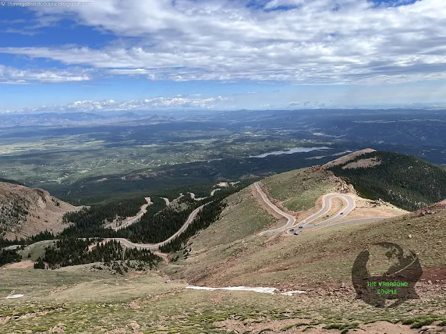 |
| Pikes Peak Highway switchbacks and reservoirs below the summit |
The highway curled below us through switchbacks, reservoirs and forested slopes. The shuttle spared Shehzadi the climb and gave us more time to look out the windows, a task vehicles generally perform without visible appreciation.
 |
| Rocky slopes and summer snow patches below the summit |
Summer snow remained on the rocky slopes. The mountain's granite is far older than the modern Front Range: the Pikes Peak batholith formed about 1.04 billion years ago, while later uplift raised the range and erosion cut the relief seen today.
 |
| The summit elevation sign inside the visitor center |
The summit visitor center provided shelter from the wind and a clear elevation marker. Outside, cloud moved across the rocks quickly enough to keep the view provisional.
 |
| A layered summer snowbank near the summit |
A layered snowbank survived beside the summit in July, looking less like winter scenery than a stubborn remnant refusing to vacate.
 |
| The red cog railway train at the cloudy summit |
The red cog railway eventually appeared at the summit, having sold its seats to people with better timing. On this morning, it provided a bright moving object in a world otherwise occupied by granite and cloud.
 |
| Mountain roads and reservoirs seen from the summit |
From the summit, mountain roads and reservoirs appeared through breaks in the cloud. The view did not need uncertain labels for distant ranges. The scale was already doing enough work.
This leg changed the expedition's geometry. Kansas had measured progress across the horizon; Pikes Peak measured it upward. Garden of the Gods showed sediment tilted by mountain building, and the summit showed the much older granite beneath the range. The road had crossed from plains into the physical structure of the Rockies.
Next Stop: Hoosier Pass and Moab
 |
| Shehzadi at Hoosier Pass on the Continental Divide |
Part 4 continues west from Colorado Springs through Hoosier Pass, Breckenridge, Vail, Glenwood Canyon and on to Moab. The road crosses the Continental Divide at Hoosier Pass, which the Colorado Department of Transportation lists at 11,539 feet. That altitude matters alongside the watershed boundary: the highway reaches a serious mountain-road elevation for travelers and vehicles alike before descending toward Breckenridge, I-70 and the long westbound route through Colorado toward Moab.
Reference route map of The Vagabond Couple's 9,000-mile USA & Mexico overland roundtrip: Map-1 and Map-2.
