
 |
| Shehzadi at Hoosier Pass, where Colorado Route 9 crosses the Continental Divide |
Part 3 carried us from Topeka across Kansas to Colorado Springs, Garden of the Gods and Pikes Peak. Part 4 begins with Shehzadi pointed west from Colorado Springs, climbing toward Hoosier Pass before joining I-70 for Glenwood Canyon and the long descent into Utah.
This leg crossed the Continental Divide, paused in Breckenridge and Vail, followed the Colorado River through one of the Interstate system’s tightest mountain corridors, and turned south at Crescent Junction for Moab. The road changed altitude, climate and geology with suspicious efficiency.
Trans-America Overland Part 4 — Post Summary
Part 4 follows our westbound drive from Colorado Springs to Moab. We cross Hoosier Pass and the Continental Divide, stop in Breckenridge and Vail, thread I-70 through Glenwood Canyon beside the Colorado River, enter eastern Utah, and turn south on US-191 for Moab and a better dinner strategy.
| What's Covered | |
| ⛰️ | Hoosier Pass and the Continental Divide — high-altitude Route 9 crossing and watershed boundary |
| ☕ | Breckenridge to Vail — mining-era Main Street, mountain roads and a brief coffee stop |
| 🛣️ | I-70 through Glenwood Canyon — Colorado River, tunnels, viaducts and a distant smoke plume |
| 🏜️ | Eastern Utah to US-191 — Book Cliffs, Cisco country, Crescent Junction and the Moab turn |
| 🌮 | Arrival in Moab — an uneven biryani, bulgogi tacos and the Food Truck Park |
We left Colorado Springs on the mountain route toward Hoosier Pass, then descended through Breckenridge to I-70. From there, Shehzadi followed the Colorado River through Glenwood Canyon, crossed into Utah, and turned south on US-191 at Crescent Junction for Moab. The route measured only one day on the calendar. The geology had scheduled several eras.
Route: Colorado Springs, Colorado, to Moab, Utah
Vehicle: Shehzadi, our Toyota Tundra
Main roads: Colorado Route 9, I-70 and US-191
Main stops: Hoosier Pass, Breckenridge, Vail and Moab
Main experiences: Continental Divide, Glenwood Canyon, eastern Utah and Moab dining
Route at a Glance
- Climb Colorado Route 9 from Colorado Springs to Hoosier Pass.
- Descend through Breckenridge and continue toward Vail.
- Follow I-70 beside the Colorado River through Glenwood Canyon.
- Cross eastern Utah to Crescent Junction and turn onto US-191.
- Reach Moab for the night and find dinner.
Hoosier Pass and the Continental Divide
Hoosier Pass carried Colorado Route 9 across the Continental Divide at 11,539 feet. The altitude mattered as much as the line on the map. Atmospheric pressure drops with elevation, so each breath delivered less oxygen than it had in Colorado Springs. A short walk at the summit therefore acquired the ambitions of a much longer one.
The Continental Divide of the Americas separates major drainage systems. Water falling east of this crest begins toward the Atlantic side of the continent, while water on the western side enters Pacific-bound basins. We would cross the divide again later in the expedition. For now, it marked the point where the road and the water both chose west.
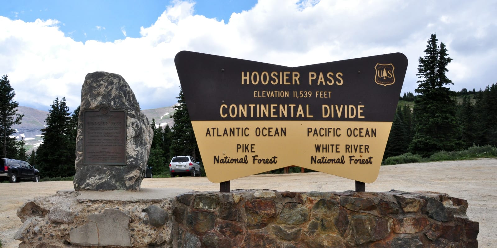 |
| The Hoosier Pass sign marks the elevation and the divide between Atlantic and Pacific drainage |
Snow remained on the higher slopes, evergreen forest filled the lower ground, and Shehzadi’s twin-turbo engine handled the climb without requesting applause. We stopped for photographs and a few deliberate breaths. The pass supplied both.
Breckenridge to Vail
The descent brought us into Breckenridge, which grew as a service center for the surrounding mining district. Its historic Main Street still carries the scale and street pattern of that era, although coffee and storefronts have replaced much of the equipment that once made holes in mountains.
We walked along Main Street, looked through a few shops and paused for coffee before returning to Shehzadi. The historic blocks were compact enough to cover on foot without turning the stop into a separate expedition. Coffee performed its traditional function: converting scenery into a schedule.
Vail was a shorter stop farther west: enough time to stretch our legs, take in the tightly planned resort center and continue toward I-70. The truck was less interested in resort distinctions than in the location of the next ramp.
I-70 Through Glenwood Canyon
Westbound I-70 entered Glenwood Canyon beside the Colorado River. The final 12.5-mile Interstate segment opened in 1992 after engineers fitted more than 40 bridges and viaducts, tunnels and stacked roadway sections into the narrow canyon. The result often places traffic above the river, below the cliffs and beside another level of traffic at the same time. It is a road with a strong belief in vertical filing.
Video: westbound I-70 through Glenwood Canyon beside the Colorado River
A recreation path and rest areas also share the corridor, squeezed between the river and Interstate wherever the canyon allows.
Beyond the canyon, a dark smoke plume rose beside the westbound route. From the highway, we could not identify the fire, its cause or what lay beneath the smoke. We could only see the plume spreading above the dry country ahead, an unwelcome reminder that a scenic road does not suspend the ordinary risks of summer.
 |
| A dark smoke plume rising beside westbound I-70 after Glenwood Canyon |
Eastern Utah to US-191
Crossing into Utah changed the view quickly. Snow-streaked mountains gave way to dry slopes, broad benches and distant mesas. A rocky roadside overlook made the transition easy to see and difficult to summarize without using several shades of brown.
 |
| A rocky roadside overlook in eastern Utah, where snow country had yielded to dry stone |
I-70 ran straight across open country, with long sight lines and little roadside clutter. The highway here was efficient in the slightly alarming way of a ruler placed across a very large map.
 |
| Westbound I-70 running straight into the open country of eastern Utah |
The posted limit rose to 80 mph. We recorded the sign and continued at a speed suitable for Shehzadi, the road and the paperwork that follows any disagreement among them.
 |
| An 80 mph speed-limit sign beside rural I-70 in eastern Utah |
The Book Cliffs accompanied the highway toward the Cisco area. At Crescent Junction, we left I-70 and turned south onto US-191. The San Rafael Swell lay farther west, beyond our turn, so Moab won the argument and received the truck.
 |
| The highway following the Book Cliffs across eastern Utah |
Arrival in Moab
US-191 delivered us to Moab, where we checked into a hotel and went looking for dinner. Shehzadi remained in the parking lot while we tested the town’s evening food options, a division of labor she accepted without objection. The biryani at an unnamed Indian restaurant tasted prepackaged and reheated to us. It was edible, technically, which is one of the lower compliments available to rice.
Moab Food Truck Park improved the odds. Food trucks stood around shaded picnic tables, and we tried bulgogi beef tacos with a sweet, savory and mildly spicy filling. The setting was casual, the meal worked, and the evening recovered without requiring a committee.
 |
| Food trucks and shaded picnic tables at Moab Food Truck Park |
From Hoosier Pass, we had crossed the watershed divide, descended into the Colorado River corridor and reached the dry rock country of the Colorado Plateau. The route linked snow, river and desert in one day. Gravity did most of the planning; the highways claimed the credit.
Next Stop: Arches, Canyonlands, Dead Horse Point and Sand Flats
Part 5 stays around Moab for Arches National Park, Canyonlands National Park, Dead Horse Point and the Sand Flats off-road trail. The long highway leg was over. Shehzadi’s red-rock work was about to become considerably less paved.
Reference route maps for our 9,000-mile USA and Mexico overland round trip: Map-1 and Map-2.
