Trans-America USA + Mexico Overland 9,000-mile 31-day Roadtrip | Part 7 | Kanab - Hurricane - St. George, Utah | Stunning Sand Caves, Coral Pink Sand Dunes State Park & Bryce Canyon National Park
 |
| Sunrise Point, Bryce Canyon |
Good morning, fellow adventurers! It’s us, the Vagabond Couple, back from Moab to Kanab, Utah | I-70 West Vistas, Arches of Red Canyon in Dixie National Forest, Kodachrome Basin & Grosvenor Arch in Grand Staircase-Escalante with another action-packed episode of our epic 9,000-mile road trip across the USA and Mexico. Today’s journey took us from the charming town of Kanab, Utah, through some of the most iconic landscapes in the American Southwest. We’re talking towering hoodoos of Bryce Canyon National Park, stunning reddish pink fine powdered sandstone sand of Coral Pink Sand Dunes State Park, a tricky climb up to hidden Sand Caves reached by a dry river bed, and a drive through Zion National Park that left us speechless. Buckle up, because this day was a whirlwind of natural wonders, Wild West history and a whole lot of awe.
Red Canyon and the Arches of Utah Hwy 12: A Fiery Start
 |
| Red Canyon, Dixie National Forest, Utah Hwy 12 (UT-12) "All American Road" |
We started our day early, hopping into Shehzadi (our trusty Toyota Tundra) and heading out of Kanab toward Bryce Canyon National Park. But before we even got to Bryce, we were treated again to the stunning beauty of Red Canyon along All-American Road: Scenic Byway 12, the most beautiful road in Utah. Driving on Utah Highway 12 through this fiery wonderland feels like entering another world. The red rock formations, towering hoodoos and natural arches glow in the morning light and driving under the two iconic arches of Red Canyon on Hwy 12 is like passing through a gateway to adventure.
 |
| The Most Beautiful Road in Utah: Red Canyon, Dixie National Forest, Utah Hwy 12 (UT-12) "All American Road" |
Red Canyon is part of Dixie National Forest and its vibrant colors come from the iron-rich Claron Formation, which was shaped over millions of years by wind, water and time.
 |
| The first Red Canyon Arch, Dixie National Forest, Utah Hwy 12 (UT-12) "All American Road" |
The Paiute people, who have lived in this area for thousands of years, consider the canyon a sacred place, filled with stories of spirits and ancient beings. It’s impossible not to feel a sense of reverence as you drive through this landscape.
 |
| The second Red Canyon Arch, Dixie National Forest, Utah Hwy 12 (UT-12) "All American Road" |
Bryce Canyon: A Forest of Hoodoos
Bryce Canyon is named after Ebenezer Bryce, a Mormon pioneer who settled in the area in the mid-1870s. He and his family were among the first to homestead in the region. The canyon itself became known as "Bryce's Canyon" because of his association with the area. Ebenezer Bryce is famously quoted as saying that the canyon was "a hell of a place to lose a cow", reflecting the rugged and challenging terrain. The name stuck and when the area was designated as a national monument in 1923 and later as a national park in 1928, it was officially named Bryce Canyon National Park in his honor. The park is renowned for its unique geological structures, including hoodoos, which are tall, thin spires of rock that rise from the bottom of arid basins and badlands. These formations create a stunning and otherworldly landscape that attracts visitors from around the globe.
 |
| Bryce Canyon National Park entrance |
When we finally arrived at the Bryce Canyon National Park visitor center parking lot, we met a Swiss couple unloading their bicycles from a Switzerland-plated campervan! It turned out they shipped their campervan from the seaport of Hamburg on river Elbe in Germany to Halifax, Nova Scotia in Canada and were overlanding Canada and the United States. They have been overlanding the world for a while and had already clocked over 50,000 KM during their adventures so far.
 |
| European couple in Swiss-plated Campervan in Bryce Canyon National Park, Utah |
Bryce Canyon is steeped in Native American history. The Paiute people, who called this area home long before it became a national park, believed the hoodoos were Legend People turned to stone by the trickster god Coyote. Standing among these ancient formations, it’s easy to see why they inspired such legends.
Sunrise Point, Bryce Canyon
We started our exploration at Sunrise Point where we were greeted by a sight that literally took our breath away: the park's famous hoodoos!
 |
| Sunrise Point |
The Hoodoo formations were created by the relentless forces of frost wedging and erosion, which carved the soft limestone into the otherworldly shapes we see today.
 |
| Sunrise Point |
Perched at an elevation of over 8,000 feet, Sunrise Point provides stunning views of the amphitheater below, including notable features like the Silent City, a maze of densely clustered hoodoos and the Boat Mesa, a prominent plateau in the distance.
 |
| Queen's Garden Trail at Sunrise Point |
The trailhead for the popular Queen’s Garden Trail begins here, descending 320 feet into the canyon and weaving through whimsical rock formations, including the Queen Victoria hoodoo, before connecting to the Navajo Loop Trail.
 |
| Sunrise Point |
This moderately easy Navajo Loop Trail hike allows visitors to experience the surreal beauty of Bryce Canyon up close, making Sunrise Point both a scenic destination and a gateway to adventure. We will walk the Navajo Loop Trail from the Sunset Point next.
Sunset Point, Bryce Canyon
 |
| Sunset Point |
The next viewpoint, Sunset Point in Bryce Canyon National Park, offers awe-inspiring views of the park’s iconic amphitheater, showcasing a mesmerizing landscape of vibrant hoodoos, spires and cliffs in hues of red, orange and white.
 |
| Navajo Loop Trail head at Sunset Point |
From this vantage point, visitors can admire prominent features such as Thor’s Hammer, a striking hoodoo with a unique top-heavy shape and the Wall of Windows, a series of natural arches carved into the rock.
Navajo Loop Trail, Bryce Canyon
 |
| Navajo Loop Trail |
The trailhead for the renowned Navajo Loop Trail begins here, descending steeply into the canyon through a series of switchbacks known as the Wall Street section, where towering cliffs and Douglas firs create a dramatic atmosphere.
 |
| Navajo Loop Trail |
The 1.3-mile Navajo Loop trail provides an immersive experience, allowing hikers to walk among the towering hoodoos and experience the surreal beauty of Bryce Canyon up close, making Sunset Point both a breathtaking destination and a gateway to unforgettable adventures.
The Navajo Loop Trail was established in the early 20th century, around the time Bryce Canyon was designated a national monument in 1923 (later becoming a national park in 1928). It was named in honor of the Indigenous Navajo people, who have a deep cultural connection to the region. The trail was designed to provide visitors with access to the park’s famous amphitheater, allowing them to descend into the canyon and experience its towering hoodoos, narrow slot canyons and vibrant rock formations up close. Today, the Navajo Loop Trail remains a must-see destination, offering a glimpse into the park’s geological wonders and rich history.
 |
| Navajo Loop Trail |
The geology of the Slot Canyons along the Navajo Loop Trail, particularly in the Wall Street section, is a testament to the powerful forces of erosion that have shaped Bryce Canyon over millions of years. The hoodoos and slot canyons are formed from the Claron Formation, a layer of sedimentary rock composed primarily of limestone, siltstone and mudstone. These rocks were deposited in an ancient lake system around 50 million years ago. Over time, water, ice and wind eroded the softer rock layers, carving out narrow, deep slot canyons and leaving behind the more resistant rock formations, such as the iconic hoodoos. The slot canyons, with their towering walls and narrow passages, are a striking example of how erosion can create dramatic and otherworldly landscapes. The interplay of light and shadow within these canyons adds to their mystique, making the Navajo Loop Trail a truly unforgettable experience.
 |
| Navajo Loop Trail |
Inspiration Point, Bryce Canyon
Next up off Bryce Canyon Road: Inspiration Point offering more sweeping panoramas of the Bryce Amphitheater and its awe-inspiring collection of hoodoos, spires and cliffs. Perched at an elevation of over 8,100 feet, this vantage point is divided into three levels, each providing progressively more expansive views of the canyon’s intricate formations.
 |
| Inspiration Point |
From Inspiration Point also, visitors can marvel at the Silent City, a dense cluster of hoodoos that resemble a skyline of ancient towers and the Bryce Amphitheater, a vast natural bowl filled with countless rock formations in vibrant shades of red, orange and white.
 |
| Inspiration Point |
The Aquarius Plateau and Bristlecone Point can be seen in the distance, adding depth to the already stunning vista. Aquarius Plateau is the highest timbered plateau in North America!
 |
| Inspiration Point |
Inspiration Point is particularly renowned for its ability to showcase the grandeur and scale of Bryce Canyon’s geological wonders, making it a favorite spot for photographers and nature enthusiasts seeking to capture the park’s breathtaking beauty.
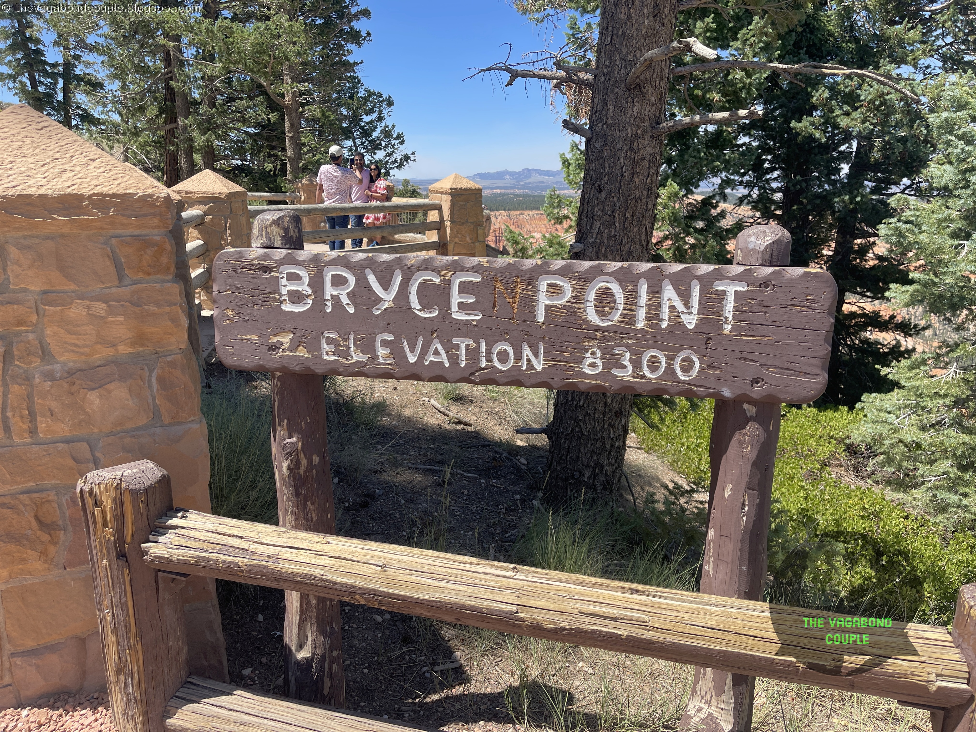
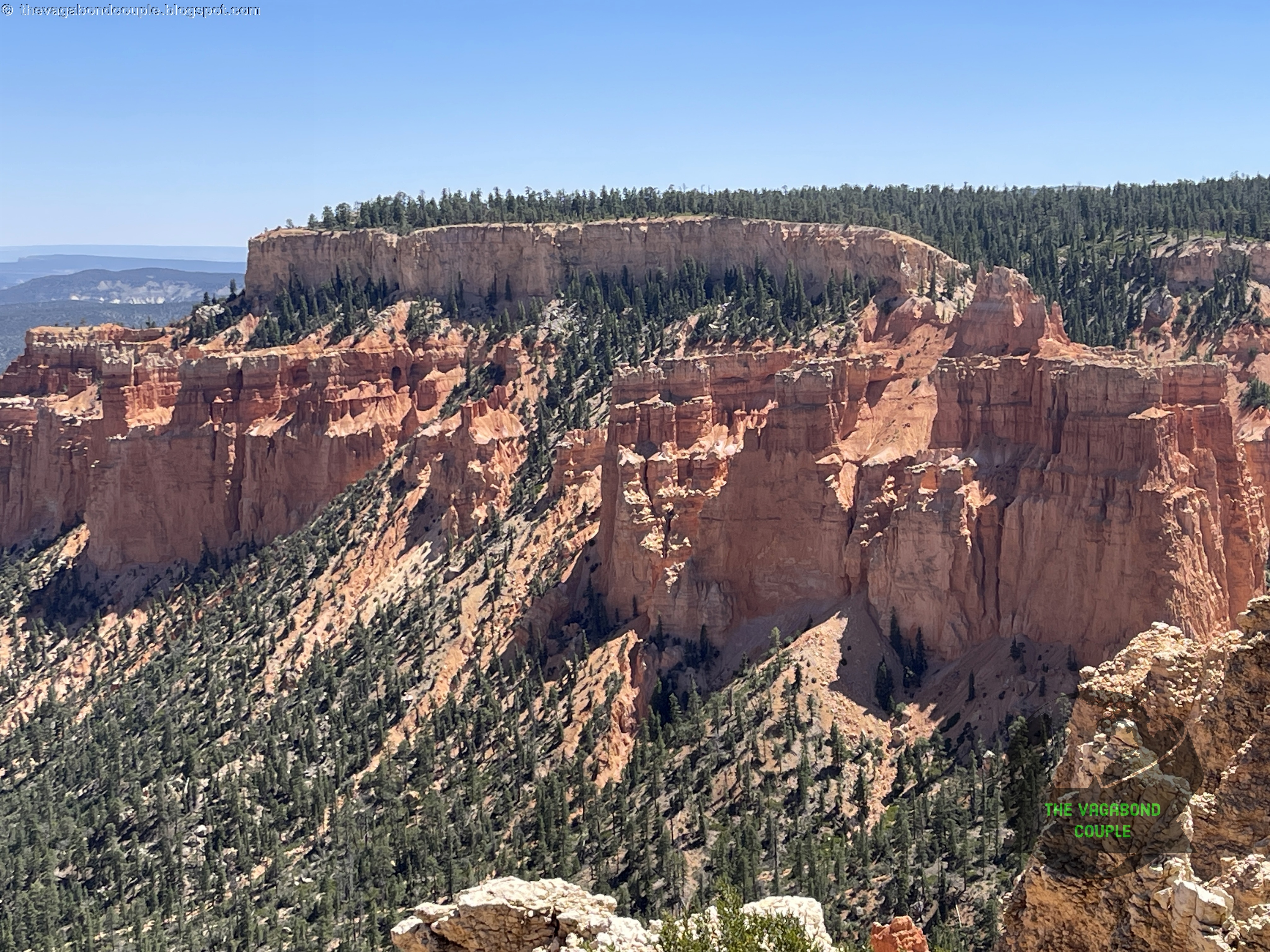
Bryce Point, Bryce Canyon
Next up: Bryce Point, also offering a jaw-dropping perspective of the Bryce Amphitheater and its countless hoodoos, spires and cliffs. Perched at an elevation of over 8,300 feet, this viewpoint provides a sweeping, panoramic vista that captures the full grandeur of the canyon’s geological wonders.
 |
| Bryce Point |
From here, visitors can see iconic features such as the Silent City, a sprawling maze of hoodoos that resemble a skyline of ancient ruins and the Sinking Ship, a striking rock formation that appears to tilt like a vessel disappearing into the earth. The Aquarius Plateau, as noted before - the highest timbered plateau in North America, looms in the distance, adding depth to the breathtaking scene.
 |
| Bryce Point |
Bryce Point is particularly renowned for its sunrise views, when the first light of day illuminates the amphitheater, casting a golden glow over the vibrant red, orange and white rock formations.
 |
| Bryce Point |
Paria View, Bryce Canyon
Our last viewpoint on this visit to Bryce Canyon was Paria View. This turned out to be a serene and less-crowded viewpoint that offers a stunning perspective of the canyon’s intricate rock formations and the vast landscape beyond.
 |
| Paria View |
Located along the southern end of the park’s scenic drive, this vantage point provides a unique view of the Paria Valley and the Table Cliff Plateau in the distance, framed by the park’s iconic hoodoos and cliffs.
 |
| Paria View |
From Paria View, visitors can admire the White Cliffs, a striking band of pale rock that contrasts beautifully with the vibrant red and orange hues of the surrounding formations. The viewpoint also overlooks the Bryce Amphitheater, though from a more secluded and tranquil angle, making it an ideal spot for those seeking a quieter experience.
 |
| White Cliffs at Paria View |
Paria View is particularly renowned for its sunset views, when the fading light bathes the canyon in warm, golden tones, creating a peaceful and picturesque scene. This hidden gem offers a perfect blend of solitude and natural beauty, making it a must-visit for those exploring Bryce Canyon.
 |
| Paria View |
We return to the Bryce Canyon Visitor Center too take a quick break before leaving the unforgettable national park. The visitor center has a sprawling parking lot and offers essential information, exhibits and resources to enhance your visit. Located near the park entrance, the center provides maps, trail guides and ranger-led programs, as well as educational displays about the park's geology, ecology and history.
 |
| Bryce Canyon Visitor Center |
Adjacent to the visitor center is a spacious parking lot, designed to accommodate the park's high volume of visitors. From here, guests can easily access the scenic Rim Trail, shuttle services and the breathtaking viewpoints along the parks scenic view road. The center and parking area are designed to be convenient and accessible, ensuring a smooth and enjoyable experience for all visitors.
Coral Pink Sand Dunes: A Desert Dream
 |
| Coral Pink Sand Dunes State Park |
After soaking in the beauty of Bryce Canyon, we retraced our route through Red Canyon and headed to Coral Pink Sand Dunes State Park. This little-visited gem of a place is like something out of a dream - a vast expanse of pink sand dunes that seem to glow in the sunlight. It is located off Hwy 89 just north of Utah's border with Arizona and Kaibab Indian Reservation. Utah backroads from Hwy 89 to the Park were some of the loneliest backroads we drove on this trip!
 |
| Coral Pink Sand Dunes |
The dunes were formed by wind erosion, which carried sand from the nearby Navajo Sandstone formations and deposited it here. More specifically, the dunes are a result of wind funneling through a notch between the Moquith Mountains and Moccasin Mountains, creating a dynamic and ever-shifting landscape. The result is a surreal landscape that feels like you’ve stepped onto another planet.
 |
| Coral Pink Sand Dunes |
We spent some time exploring the dunes, climbing to the top of one for a panoramic view of the park. The park covers approximately 3,730 acres and offers opportunities for hiking, photography and off-road vehicle recreation. After the incredibly crowded Bryce Canyon, seeing a few odd souls stumbling through the sand desert of this park was a refreshing change!
 |
| Coral Pink Sand Dunes |
The area has a rich history tied to Native American cultures, particularly the Paiute people, who have lived in the region for centuries. According to Paiute folklore, the dunes and surrounding landscapes are imbued with spiritual significance.
 |
| Coral Pink Sand Dunes |
One legend tells of the "Coyote", a trickster figure in many Native American stories, who is said to have created the dunes while playing and running through the area. Another tale speaks of the dunes as a place where the spirits of ancestors reside, watching over the land and its people.
 |
| Coral Pink Sand Dunes |
European settlers arrived in the 19th century and the region became part of the expanding frontier. The park was officially established in 1963 to preserve the unique geological features and provide recreational opportunities.
 |
| Coral Pink Sand Dunes |
The sand is incredibly fine and soft and it’s easy to lose yourself in the beauty of this place. The park is also home to a variety of wildlife, including the unique Coral Pink tiger beetle which is found nowhere else in the world.
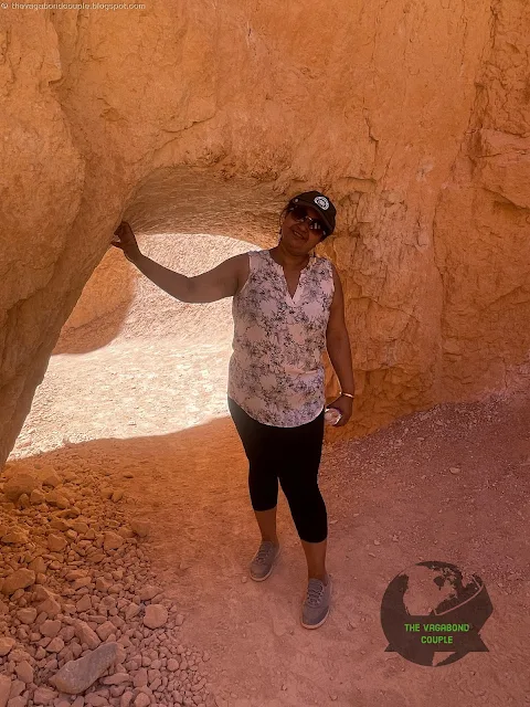
Sand Caves: A Hidden Gem
 |
| Sand Caves |
Next up were the Sand Caves, a lesser-known but equally stunning destination near Kanab. The parking lot is barely 1 and a ½ miles detour from southbound Hwy 89 towards Kanab! It is not clear who owns or manages this place, but the parking lot has portable toilets and a couple of trash bins and the trail is somewhat marked.
 |
| Sand Caves |
To reach the caves, after parking, we hiked along a dry riverbed trail, surrounded by towering sandstone cliffs. The trail is relatively easy at first, but the final climb up to the caves is moderately challenging, requiring a bit of scrambling over rocks.
 |
| Sand Caves |
The effort is well worth it. The Sand Caves are a series of open, cavern-like spaces carved into the sandstone by wind and water. Inside, the walls are smooth and curved, with natural windows that frame breathtaking views of the surrounding landscape. We sat inside one of the caves for a while, soaking in the views and the peaceful silence.
 |
| Sand Caves |
The Sand Caves are carved into the Navajo Sandstone, a prominent rock layer in the region that dates back to the Jurassic period, approximately 190 million years ago. The formation process began with the deposition of vast amounts of sand in ancient desert environments, which over time, compacted and cemented into sandstone.
 |
| Sand Caves |
The distinctive curves and hollows of the Sand Caves were shaped primarily by wind erosion. Strong winds carrying sand particles gradually wore away the softer parts of the sandstone, creating the smooth, flowing contours and alcoves that characterize the caves.
 |
| Sand Caves |
Additionally, water played a role in the formation. Rainwater, when it does occur in this arid region, can seep into cracks and joints in the sandstone. Over time, this water can dissolve the natural cement holding the sand grains together, further eroding the rock and enlarging the cavities.
 |
| Sand Caves |
The result is this series of picturesque, wave-like formations and hollowed-out spaces that are popular among visitors for their unique beauty and the opportunity to explore and photograph these natural wonders.
Highway 9 Through Zion (Zion - Mount Carmel Highway): A Drive to Remember
From the Sand Caves, we made our way to Hurricane, Utah via northbound Highway 89 and then westbound on the famous Utah State Route 9 (UT-9, Utah Hwy 9, Utah SR-9) Zion - Mount Carmel Highway. This route took us through Zion National Park and while we didn’t stop today (we’re saving Zion for tomorrow), the drive was unforgettable. Highway 9 winds through the park, offering stunning views of towering cliffs, deep canyons and the Virgin River.
 |
| Zion - Mount Carmel Hwy: Utah State Route 9 (SR-9) |
The highlight of the drive is the Zion-Mount Carmel Tunnel, a 1.1-mile-long engineering marvel that cuts through the solid rock of the park. Driving through the tunnel feels like entering another world and when you drive west towards it, you’re greeted by the breathtaking beauty of Zion’s east side.
Hurricane, Utah: A Taste of the Wild West
 |
| A metal sculpture in Hurricane, Utah |
We crossed the spectacular Hurricane Valley and rolled into Hurricane just in time for lunch, stopping at a fantastic Mexican restaurant (Las Lupitas Mexican Grill) that felt like stepping back in time. The walls were adorned with posters of Mexican and American outlaws from the Wild West and we couldn’t help but get lost in the stories of bandits, lawmen and frontier justice. Here are a couple of them:
Candelario Cervantes, Pablo Lopez, Francisco Beltran and Martin Lopez
 |
| Reward notice for capture of outlaws Candelario Cervantes, Pablo Lopez, Francisco Beltran and Martin Lopez in Hurricane, Utah |
In the early 20th century, Candelario Cervantes, Pablo Lopez, Francisco Beltran and Martin Lopez were notorious outlaws with ties to the Mexican Revolution and border raids. Wanted for crimes ranging from robbery to murder, these men were pursued by U.S. authorities across the Southwest. Arrest warrants were issued for them and at one point, law enforcement tracked them to Hurricane, Utah, this small but growing Mormon settlement. The rugged desert terrain and hidden canyons of southern Utah made it an ideal hideout for fugitives on the run. Though the details of their time in Hurricane remain murky, their presence in the region added to the area's long history of outlaw legends and frontier justice.
Emiliano Zapata
 |
| Poster of Emiliano Zapata in Hurricane, Utah |
There is no historical record of Emiliano Zapata, the famed Mexican revolutionary leader, ever being in Hurricane, Utah, during the Wild West days. However, the rugged landscapes of southern Utah, including Hurricane, were known as hiding spots for outlaws and fugitives on the run. If Zapata or his associates had ventured into this region, it would have been as part of an escape route or temporary refuge from authorities. The remote canyons, mesas and deserts of Utah made it an ideal place for lawbreakers to disappear, much like how Zapata and his revolutionaries used the mountains and jungles of Morelos, Mexico to evade government forces. While his influence was primarily in Mexico, stories of legendary outlaws traveling through the American West have long blurred the lines between fact and folklore.
Hurricane itself is a charming town with a rich history. Named for the strong winds that blow through the area, it was settled by pioneers in the late 19th century. The town’s proximity to Zion National Park and other natural wonders has made it a popular destination for adventurers and history buffs alike.
Saint George, Utah: A Quiet Night in the Desert
After a long day of exploring, we made our way to St. George, where we checked into a cozy hotel (St. George Inn & Suites) for the night. We were very much in the middle of the great Moab desert with Shehzadi's thermometer reading 113 degrees Fahrenheit.
 |
| St. George Inn & Suites |
St. George is a vibrant town with a rich history and a stunning backdrop of red rock cliffs. It’s also the gateway to Zion National Park, making it the perfect base for tomorrow’s adventures.
As we settled in for the night, we couldn’t stop talking about everything we’d seen today - from the hoodoos of Bryce Canyon to the pink sand dunes and hidden caves. Utah continues to amaze us at every turn and we can’t wait to see what tomorrow brings at the famed Zion National Park.
In addition to showing 113 degrees outside temperature, Shehzadi's odometer at this point was at 9,441 miles, which means we had now traveled 3,046 miles from home back in Hyattsville, Maryland. This also meant we have come a third of our planned 9,000 miles of this epic road-trip across the United States and Mexico.
 |
| Shehzadi (2024 Toyota Tundra) Odometer 9,441 miles: 3,046 miles from home, and 113 degrees outside temperature at St. George, Utah |
Tomorrow, we visit the legendary Zion National Park (see Journey Through Towering Cliffs and Canyons of Wonder at Zion National Park). Until then, fellow wanderers, keep exploring, keep dreaming and remember: the journey is just as important as the destination.
Reference route map of The Vagabond Couple's 9,000-mile USA & Mexico overland roundtrip: Map-1 and Map-2.
— The Vagabond Couple & Shehzadi
0 comments