Trans-America USA + Mexico Overland 9,000-mile 31-day Roadtrip | Part 6 | Moab to Kanab, Utah | I-70 West Vistas, Arches of Red Canyon in Dixie National Forest, Kodachrome Basin & Grosvenor Arch in Grand Staircase-Escalante
.jpg "The double arches of Grosvenor Arch, Kodachrome Basin, Grand Staircase-Escalante, Utah") |
| The double arches of Grosvenor Arch, Kodachrome Basin, Grand Staircase-Escalante, Utah |
Get ready for another thrilling chapter in the Vagabond Couple’s epic 9,000-mile road trip! After conquering Moab’s rugged Sand Flats 4x4 Offroad Trail (see "Arches National Park, Canyonlands National Park, Dead Horse Point State Park & Sand Flats Offroad Trail Recreation Area | Moab, Utah"), we hit the road towards Kanab, Utah, with surprises, stunning scenery and a touch of serendipity along the way. From a chance encounter with fellow Maryland roadtrippers to the jaw-dropping beauty of I-70’s San Rafael Reef and Black Dragon Canyon, every mile was a feast for the eyes. We detoured through the fiery wonderland of Red Canyon, marveled at the double arches of Grosvenor Arch in Kodachrome Basin and soaked in the rich Native American history and legends of the Grand Staircase-Escalante area. As the sun set, we rolled into Kanab, exhausted but exhilarated, ready for tomorrow’s adventures at Bryce Canyon and beyond. Buckle up - this journey is just getting started!
As we left Moab, something caught our eye - a van with Maryland plates! What were the chances? Even more intriguing was the signage on the back: “Senior Road Trip - Maryland to California”.
 |
| Senior Road Trip - Maryland to California |
Instinctively, we honked and waved and to our delight, the couple enthusiastically honked and waved back. It was a small but heartwarming reminder that the road is full of kindred spirits, all chasing adventure in their own way. Perhaps they will come across this blog some day and get in touch?
The Scenic Majesty of I-70
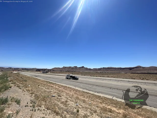
Once on I-70, the Utah landscape unfolded before us in a grand display of nature’s artistry. The San Rafael Reef came into view, a jagged, tilted ridge of Navajo sandstone sculpted over millions of years. This dramatic barrier was once a formidable challenge for pioneers and its name comes from the Catholic missionary San Rafael, who was said to watch over travelers. We imagined early explorers staring at this massive wall of rock, wondering how on earth they’d get through.
San Rafael Reef
 |
| San Rafael Reef, Interstate 70, Utah |
The San Rafael Reef is one of those places that makes you stop in your tracks, mouth open, wondering how the earth managed to fold and twist itself into such a masterpiece. This jagged, tilted wall of rock marks the eastern edge of the San Rafael Swell, a massive geological uplift that formed over 60 million years ago.
 |
| San Rafael Reef, Interstate 70, Utah |
The layers of red and orange sandstone were once flat, but over time, they were forced upward, cracking and eroding into the dramatic ridges and canyons we see today. It’s like nature’s version of an abstract sculpture, shaped by wind, water and time.
 |
| Information Board at San Rafael Reef View Area, I-70, Utah |
If you’ve ever driven through this area on Interstate 70, you’ve actually passed through one of the most impressive engineering feats in the region. Blasting a highway through the reef in the late 1960s was no small task; crews had to carve a path through solid rock, creating a route that now offers some of the most scenic highway views in the United States.
 |
| Interstate 70 at San Rafael Reef, Utah |
But long before highways and road trips, this land was home to Native American tribes, including the Ute and Fremont people. They left behind petroglyphs and pictographs on canyon walls, telling stories that we may never fully understand. Some legends say the reef was a kind of spiritual barrier, a place where only the bravest would venture. And deep within its winding slot canyons lies The Squeeze, a narrow and challenging route for modern-day adventurers. It’s a tight, twisting slot canyon with pools, drop-offs and obstacles that make it a true test for canyoneers. Imagine what it must have been like for early travelers—no ropes, no gear, just the raw courage to push forward.
 |
| San Rafael Reef, Interstate 70, Utah |
Black Dragon Canyon
Soon, we approached Black Dragon Canyon, a place steeped in Native American history. Named after a petroglyph that resembles a dragon, this canyon was once home to the Fremont and Ancestral Puebloan peoples. Legends speak of spirits guarding these cliffs, their whispers carried by the wind through the winding ravines. We didn’t see any dragons, but the towering walls and deep shadows certainly made the place feel mystical.
 |
| Black Dragon Canyon, I-70, Utah |
If you’ve ever driven Interstate 70 through Utah’s rugged backcountry, you might have zoomed past Black Dragon Canyon without realizing the incredible history hidden in its walls. This dramatic canyon, carved by water over millions of years, slices through the San Rafael Swell. Black Dragon Canyon is one of the Swell's most striking features.
It gets its name from a famous pictograph - a black, dragon-like figure painted by the Fremont people over a thousand years ago. Some say it looks like a winged beast, others see a giant bird, but whatever it is, it’s a haunting reminder that this place was sacred long before asphalt and road trips.
Across I-70 and slightly to the east, Spotted Wolf Canyon View Area offers one of the most jaw-dropping overlooks on I-70, where the highway squeezes through a narrow sandstone pass - one of the last sections of Interstate 70 to be completed in the U.S.
 |
| Black Dragon Canyon, Interstate 70, Utah |
Before the I-70 freeway, only rugged trails and old mining roads wound through these canyons. Native American tribes, including the Ute and Paiute, believed this land was home to powerful spirits. Some legends speak of supernatural creatures that guarded the canyons and honestly, standing beneath those towering walls, you can feel the weight of history pressing in. Whether you’re stopping for a quick look at the Black Dragon pictograph or exploring the canyon’s twisting passages, this place is a hidden gem on one of America’s loneliest highways.
Chimney Rock
 |
| Chimney Rock |
Further down I-70, Chimney Rock jutted out against the horizon—a lone sentinel in the desert. This geological marvel was formed over eons, with wind and rain chiseling away at softer rock. Some Native American stories describe it as a watchtower, a place where spirits stand guard over the land. Its isolated, towering presence made it easy to see why.
 |
| Chimney Rock, I-70, Utah |
Cruising along I-70 through Utah, you can’t miss Chimney Rock, a towering sandstone pillar rising from the desert floor like an ancient sentinel. Located near the Chimney Rock View Area, this rugged rock formation stands as a testament to the relentless forces of erosion that have shaped the San Rafael Swell for millions of years.
 |
| Chimney Rock View Area, Interstate 70, Utah |
Formed from Entrada Sandstone, Chimney Rock was once part of a massive rock layer deposited in an ancient desert, long before dinosaurs roamed this land. Over time, wind and water carved away the softer rock, leaving behind this striking column that now watches over travelers passing through one of the most remote stretches of the American West. Native American tribes like the Ute and Fremont people left their mark in this region and some legends tell of great warriors who turned to stone, standing forever as guardians of the land.
 |
| Chimney Rock View Area, Interstate 70, Utah |
Again, when I-70 was blasted through the San Rafael Swell in the 1960s and ‘70s, it was one of the most ambitious highway projects in the country.
Wild West Outlaws
Chimney Rock in Utah has long been a landmark for travelers, but it also played a role in the legends of the Wild West outlaws who once roamed this rugged country. Stories tell of Butch Cassidy and the Wild Bunch using the towering rock as a waypoint while escaping lawmen through the San Rafael Swell.
 |
| Outlaw Country Information Board, Chimney Rock View Area, I-70, Utah |
The maze-like canyons and rocky hideouts provided the perfect cover for horse thieves and train robbers, allowing them to vanish into the landscape. Some say hidden stashes of stolen loot still lie buried in the nearby cliffs, waiting for an adventurous soul to uncover them.
Whether truth or tall tale, Chimney Rock remains a symbol of the untamed frontier and the daring figures who defied the law in its shadow.
Ghost Rock
Ghost Rock came next on I-70, its eerie name derived from the way the white cliffs appear spectral at dawn and dusk. Native legends tell of wandering spirits who once lived here, their presence felt in the quiet solitude of the high desert. We stopped at the viewpoint and let the vast silence sink in - just us, Shehzadi and the whispers of the past.
 |
| Ghost Rock looms over passing tractor-trailer on Interstate 70 in Utah |
Driving Interstate 70 through Utah’s remote badlands feels like crossing another planet and Ghost Rock View Area is one of its most otherworldly stops. Perched on the edge of the San Rafael Swell, this high-elevation overlook offers jaw-dropping views of jagged canyons, deep ravines and towering rock formations that seem to glow in the desert sun. It is located across I-70 Chimney Rock Viewing Area on the south side.
The most famous of these is Ghost Rock, a pale, weathered sandstone monolith that looks eerily like a ghostly figure watching over the land. The rock itself is part of the Curtis Formation, a layer of sandstone deposited when this area was covered by an ancient sea millions of years ago. Wind and water erosion have sculpted the landscape into bizarre shapes, making it easy to see why early travelers thought the rock formations looked like wandering spirits frozen in stone.
 |
| Ghost Rock View Area, I-70, Utah |
Long before I-70 cut through this wild landscape, Native American tribes like the Ute and Paiute told stories of spirits haunting these high cliffs. Some legends speak of ancient warriors whose souls were trapped in the stone, forever watching over the canyon below.
Ghost Rock View Area is one of the best places to pull over, stretch your legs and soak in the rugged beauty of this untamed land. If you’re lucky, you might even catch the sunset casting long, ghostly shadows across the desert - just enough to make you wonder if the legends are true.
Sand Beach & Salt Wash
Continuing along westbound I-70 in southern Utah, we found ourselves pulling over at the Sand Beach View Area to the south of the highway and then looping around to Salt Wash View Area on the north of I-70. The two stunning roadside stops offer more glimpses into the untamed beauty of the San Rafael Swell.
 |
| Sand Bench View Area, Interstate 70, southern Utah |
The Sand Beach View Area gets its name from the ancient sand dunes that hardened into rock over millions of years, creating the dramatic formations we see today. It’s incredible to think that this entire region was once covered by a vast, shifting desert, long before dinosaurs roamed these lands.
 |
| Salt Wash View Area, Interstate 70, southern Utah |
The Salt Wash area, on the other hand, tells a different story, carved out by water over eons, leaving behind deep canyons and colorful rock layers that geologists call the Morrison Formation - rich in fossils and history. Today's Salt Wash is a dry riverbed that had carved its way through the sandstone. Millions of years ago, this entire region was an ancient seabed and even today, fossils of marine life can be found embedded in the rock. The desert had once been an ocean - a mind-blowing thought as we drove through its arid beauty.
Both spots were crucial in the construction of I-70, which again was one of the most challenging highway projects in the U.S. Engineers had to cut through solid rock and navigate treacherous terrain to complete this stretch of road in the 1970s.
But long before modern travelers cruised I-70, Native American tribes, including the Ute and Fremont people, passed through here too, leaving behind petroglyphs and stories of spirit guardians watching over the land. Some legends speak of shadowy figures that roam the canyon walls at dusk, protecting the sacred lands from intruders.
A PLACE NOBODY WANTED
 |
| A place nobody wanted: Information Board posted at Salt Wash View Area |
There is a visitor information board at Salt Wash View Area that tells the fascinating story of settling of the harsh desert. When the Mormons fled to Utah in 1847, they sought out places no one else wanted, hoping to build communities in the harsh but open lands of the West. Under Brigham Young’s leadership, they were "called" to settle new towns, with the final call coming on August 22, 1877, when settlers from Sanpete Valley were sent to colonize Castle Valley, located between the Wasatch Plateau and the San Rafael Swell.
Most of the settlers were young and full of hope, eager to claim land and start fresh. But the rugged landscape wasn’t for everyone. Hanna Olsson Seely, one of the first women in the valley, famously cursed the decision to settle there, calling it a "God-forsaken country." Still, she stayed - like many others - working hard to build a home in the unforgiving desert.
Wildfire?
As we approached the exit for Highway 89 off Interstate 70, we saw what looked to us like another wildfire on the mountains.
 |
| Wildfire (?) off I-70 and U.S. Route 89 (Hwy 89), southern Utah |
If this was indeed a wildfire, it was the second wildfire we saw billowing smoke visible from I-70, after the one at Glenwood Canyon when driving from Colorado Springs, Colorado to Moab, Utah.
We exited westbound I-70 onto southbound US Hwy 89.
Red Canyon and the Natural Arches over UT-12
 |
| Dixie National Forest - Red Canyon - West Entrance (Utah Scenic Byway UT-12) |
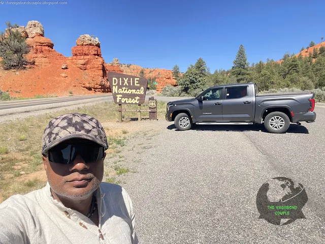
As we neared the Dixie National Forest on Hwy 89, we couldn’t resist taking a detour onto Utah State Route 12 (UT-12), the famous "Scenic Byway 12 All American Road". This led us into Red Canyon, a place so vividly colored it looked like it belonged on another planet.
 |
| Red Canyon |
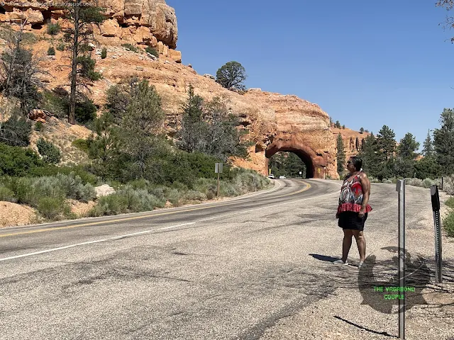
The two iconic arches over Highway 12 at Red Canyon, Utah, are striking natural rock formations that serve as a breathtaking gateway to the scenic byway. These red sandstone arches, shaped by millions of years of erosion, frame the road beautifully, offering a dramatic introduction to the vibrant landscapes of the area. Located within Dixie National Forest, the arches are a popular stop for travelers, providing excellent photo opportunities and a glimpse into the region's unique geology. Their vivid red hues, caused by iron oxide in the rock, contrast stunningly against the blue skies, making them a memorable highlight of the journey through Utah's stunning canyon country.
 |
| One of the two arches Arch over Hwy 12, Red Canyon (Dixie National Forest) |
The towering hoodoos, fiery red rock spires and Ponderosa pines made for an incredible sight. The road took us right under two legendary arches, a gateway into a world of geological wonders where the oxidation of iron minerals within the sedimentary rock layers combined with the erosional processes that have exposed these colorful layers to view.
 |
| The other arch over Hwy 12, Red Canyon (Dixie National Forest) |
Red Canyon is often called “Bryce Canyon’s little cousin,” but it stands proudly on its own. The All-American Road: Scenic Byway 12 is also considered the most beautiful road in Utah.
 |
| The two arches over Scenic Byway 12, Red Canyon (Dixie National Forest) |
Paiute legends tell of supernatural beings who were turned into stone here, their spirits forever watching over the land. The way the rocks glowed in the afternoon sun, it was easy to believe those stories.
Watch: Driving Up and Down the Red Canyon at Dixie National Forest: The "Mini Bryce" & Two Arches
Into the Grand Staircase Escalante: Kodachrome Basin & Grosvenor Arch
The Grand Staircase-Escalante National Monument in southern Utah is a vast, rugged landscape of stunning geological beauty, featuring colorful cliffs, deep canyons and unique rock formations. This area is like a giant staircase, with each "step" of the "staircase" representing a different layer of Earth’s history, from the pink and white cliffs of the Cretaceous period to the deep red rocks of the Jurassic era.
 |
| Grand Staircase Escalante Information Board at Kodachrome Basin State Park |
Over millions of years, wind, water and time carved this land into a breathtaking natural wonder. The region is also rich in history and culture. Native American tribes, including the Ancestral Puebloans and later the Paiute and Navajo, have lived here for thousands of years. They left behind artifacts, rock art and stories that speak of their deep connection to the land.
According to Native American legends, the towering cliffs and winding canyons are sacred places, often tied to creation stories or spiritual journeys. European settlers and explorers later passed through, leaving their own marks on the land, including old pioneer trails and homesteads.
Today, the Grand Staircase-Escalante is a place of adventure and discovery, where visitors can explore its geological wonders, learn about its ancient and more recent history and feel the timeless spirit of the land. It’s a treasure trove of natural beauty, cultural heritage and stories that continue to inspire awe and respect.
Back on the road, we entered the Grand Staircase-Escalante region and set our sights on Kodachrome Basin State Park.
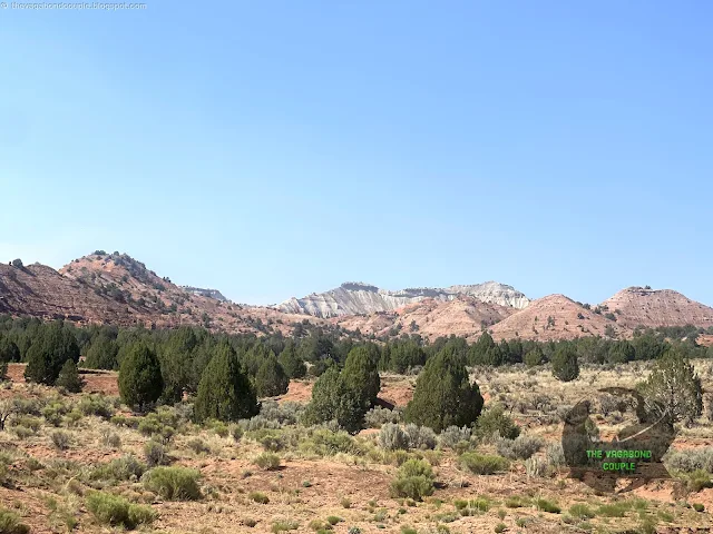
Kodachrome Basin State Park
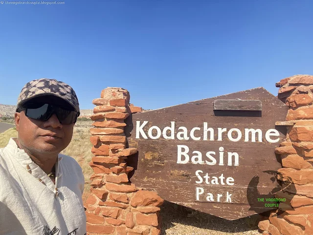 |
| Kodachrome Basin State Park Entrance |
Named after the famous Kodak film for its breathtaking colors, the park lived up to its name.
 |
| Kodachrome Basin State Park, Grand Staircase-Escalante, Utah |
Towering rock spires, known as sedimentary pipes, rose dramatically from the valley floor, their origins a mystery even to geologists.
 |
| Kodachrome Basin State Park, Grand Staircase-Escalante, Utah |
Cottonwood Canyon Road (Rt. 7000), a scenic byway that winds through the stunning landscapes of Kodachrome Basin State Park and Grand Staircase-Escalante National Monument, offers a unique blend of paved and unpaved sections that showcase the raw beauty of southern Utah.
 |
| Kodachrome Basin State Park, Grand Staircase-Escalante, Utah |
The road begins as a smooth, paved route, allowing easy access for all vehicles, but transitions into a rugged, unpaved path that demands high-clearance or 4x4 vehicles, especially after rain or snow.
 |
| Kodachrome Basin State Park, Grand Staircase-Escalante, Utah |
As you travel along this diverse route, you’re treated to breathtaking views of towering red rock cliffs, expansive desert vistas and the vibrant hues of the surrounding sandstone formations.
 |
| Cottonwood Canyon Road (Rt. 7000), Kodachrome Basin State Park, Grand Staircase-Escalante, Utah |
Kodachrome Basin State Park is a geological wonderland renowned for its vibrant array of colors and unique rock formations. The park’s striking palette - ranging from deep reds and oranges to soft pinks, yellows and whites - is the result of millions of years of sedimentary deposition and erosion.
 |
| Kodachrome Basin State Park, Grand Staircase-Escalante, Utah |
The layers of rock, primarily composed of sandstone, shale and limestone, were deposited during the Jurassic and Cretaceous periods when the area was covered by ancient seas, rivers and deserts.
 |
| Kodachrome Basin State Park, Grand Staircase-Escalante, Utah |
Iron oxide minerals within the sandstone create the rich red and orange hues, while manganese and other minerals contribute to the purples and blacks.
 |
| Kodachrome Basin State Park, Grand Staircase-Escalante, Utah |
The lighter tones, such as white and yellow, are often the result of leaching or the presence of calcium carbonate.
 |
| Kodachrome Basin State Park, Grand Staircase-Escalante, Utah |
Towering sand pipes, the park’s signature geological features, add to the dramatic landscape, formed by ancient seismic activity that forced sediment upward through cracks in the earth.
 |
| Kodachrome Basin State Park, Grand Staircase-Escalante, Utah |
This interplay of geological processes and mineral composition makes Kodachrome Basin a vivid testament to the dynamic forces that have shaped the Colorado Plateau over eons.
The canyon itself is a haven of natural beauty, with cottonwood trees lining the creek beds, their golden leaves shimmering in the fall and the ever-changing play of light and shadow on the rugged terrain. Whether you’re driving the paved sections or venturing into the rougher, remote stretches, Cottonwood Canyon Road immerses you in the untamed splendor of Utah’s desert wilderness.
 |
| Cottonwood Canyon Road |
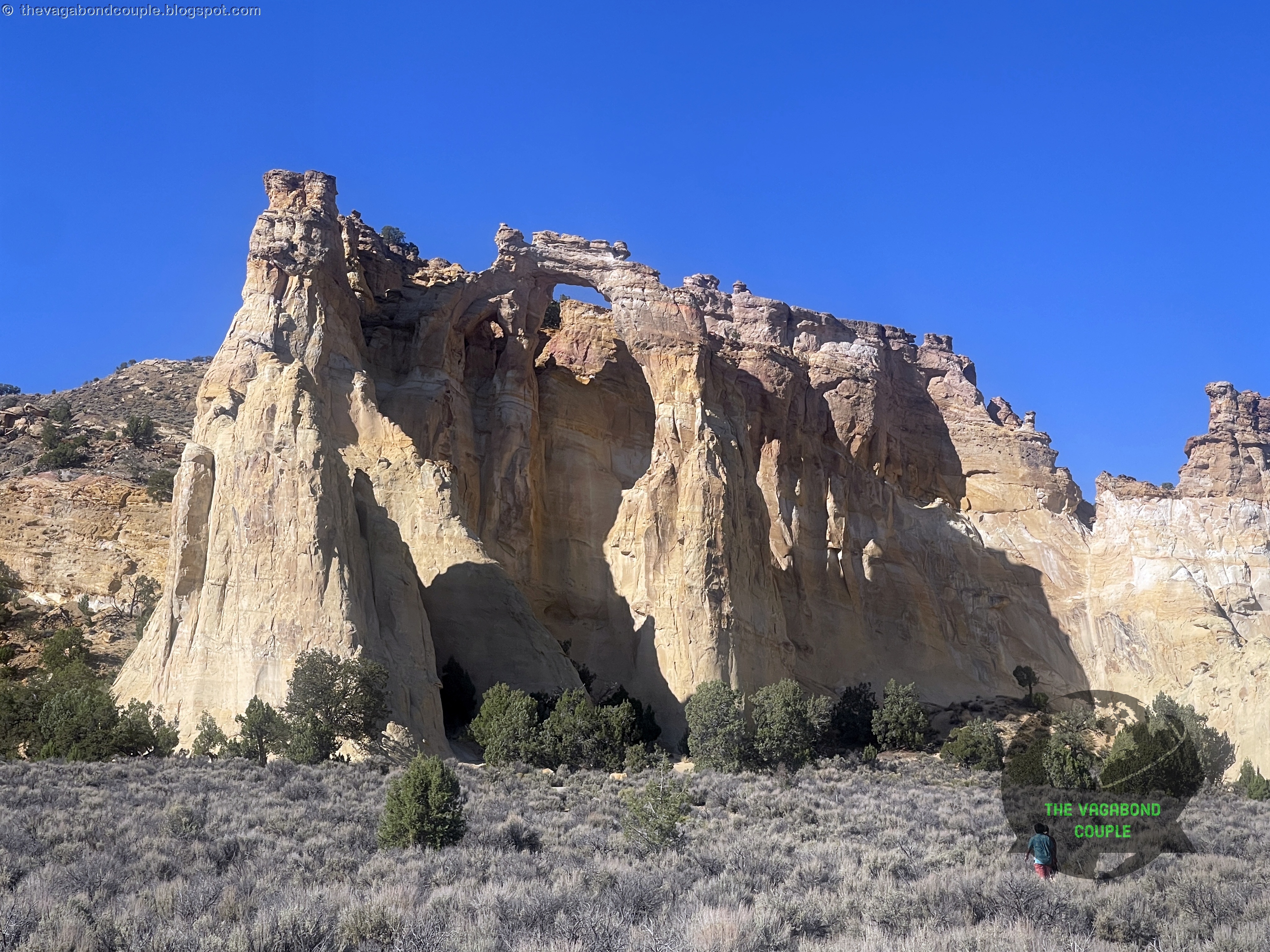
Determined to see something truly special, we took Shehzadi onto a rugged 4x4 trail leading to Grosvenor Arch, a rare and spectacular double arch.
Grosvenor Arch
The drive to Grosvenor Arch involves navigating an unpaved, rugged road that adds to the adventure of visiting this remote natural wonder. From Cannonville, Utah, take Cottonwood Canyon Road (BLM Road 400) south for approximately 10 miles, then turn onto the clearly signed Grosvenor Arch Road (BLM Road 230), a rough dirt and gravel path that stretches about 6 miles to the arch.
Watch: Grosvenor Arch, Kodachrome Basin State Park, Grand Staircase Escalante National Monument, Utah, USA
The road is typically passable for high-clearance vehicles, but conditions can vary depending on weather; it may become muddy or deeply rutted after rain, making four-wheel drive advisable. Drivers should exercise caution, carry spare tires and be prepared for a slow, bumpy journey through the stunning desert landscape of the Grand Staircase-Escalante National Monument.
 |
| Grosvenor Arch |
The remote gem of Grosvenor Arch is named after National Geographic’s Gilbert Grosvenor and its massive sandstone spans left us speechless.
 |
| Grosvenor Arch |
According to local Native American legends, the arch is a sacred place, a portal between worlds where spirits pass through.
 |
| Grosvenor Arch |
Standing beneath it, surrounded by silence except for the occasional desert breeze, we felt an indescribable connection to the ancient land.
 |
| Grosvenor Arch |
Scientifically, Grosvenor Arch provides valuable insights into the erosional patterns and stratigraphy of the area, offering a window into the Earth's ancient environments.
 |
| Grosvenor Arch |
The towering presence of Grosvenor Arch and intricate formation make it a key site for both geological research and public admiration.
 |
| Grosvenor Arch |
The Final Stretch to Kanab
As the sun dipped below the horizon, we carefully navigated the off-road trail back to the highway. The desert took on a surreal beauty, bathed in deep purples and oranges, the last light of day playing tricks on the rock formations. By the time we reached Kanab, our stomachs were growling. We found a cozy diner called "Peekaboo Canyon Wood Fired Kitchen", devoured a hearty meal and reflected on the incredible day we had just experienced.
 |
| Peekaboo Canyon Wood Fired Kitchen, Kanab |
Peekaboo Canyon, located near Kanab, Utah, is an impressive slot canyon renowned for its narrow passageways, swirling sandstone walls and vibrant colors. Often referred to as "Peek-a-Boo Gulch" this canyon is part of the larger Grand Staircase-Escalante National Monument and is a popular destination for hikers and photographers. The canyon is characterized by its intricate curves, sculpted arches and light beams that filter through the narrow openings, creating a magical and otherworldly atmosphere. Accessing Peekaboo Canyon typically requires a high-clearance 4x4 vehicle to navigate the rough dirt road to the trailhead, followed by a short but adventurous hike that may involve scrambling over rocks and wading through shallow water. We skipped it because we were eventually headed to the mother of all slot canyons on planet Earth: Antelope Canyon, a story we will tell in a future episode of this blog series.
Tomorrow, we’d wake up early for Bryce Canyon, followed by the Sand Caves and Coral Pink Sand Dunes. But for now, sleep beckoned and we let the desert night wrap around us like a warm embrace, ready for another day of adventure. By the time we hit the bed at the Days Inn & Suites by Wyndham Kanab, Shehzadi's odometer was showing 9,163 miles, an impressive 2,768 miles from home back in Hyattsville, Maryland on the Atlantic East Coast!
 |
| Shehzadi's Odometer 9,163 Miles at Kanab, Utah; 2,768 Miles from Home in Hyattsville, Maryland |
For the next episode of the story of our epic roadtrip, see "Kanab - Hurricane - St. George, Utah | Stunning Sand Caves, Coral Pink Sand Dunes State Park & Bryce Canyon National Park".
Reference route map of The Vagabond Couple's 9,000-mile USA & Mexico overland roundtrip: Map-1 and Map-2.
- Vagabond Couple & Shehzadi
0 comments